TopoQuest Logo
Do you find TopoQuest useful?
Help keep TopoQuest running and adding new maps/features by donating!
Bitcoin:  19c7KJd3qBynnjoSw5npx9KScwjBe4ifkT
Litecoin:  LXs6TkuXGGXo1vDsWCkWVdjQX94eUKd6ui
Home View Maps Find Maps Find Places Resources & Links


Tuckerton, New Jersey Topographic Map

USGS Map Title: Tuckerton, NJ
USGS Map MRC: 39074E3
DRG (GeoTIFF) Download: o39074e3.tif


Neighboring USGS Topographic Map Quads:


  Oswego Lake, NJ  
39074F4
 

  West Creek, NJ  
39074F3
 

  Ship Bottom, NJ  
39074F2
 

  New Gretna, NJ  
39074E4
 

  Tuckerton, NJ  
39074E3
 

  Beach Haven, NJ  
39074E2
 

  Oceanville, NJ  
39074D4
 

  Brigantine Inlet, NJ  
39074D3


Map MRC Location:

N40°
W75°
N40°
W74°
H8 H7 H6 H5 H4 H3 H2 H1
G8 G7 G6 G5 G4 G3 G2 G1
F8 F7 F6 F5 F4 F3 F2 F1
E8 E7 E6 E5 E4 E3 E2 E1
D8 D7 D6 D5 D4 D3 D2 D1
C8 C7 C6 C5 C4 C3 C2 C1
B8 B7 B6 B5 B4 B3 B2 B1
A8 A7 A6 A5 A4 A3 A2 A1
N39°
W75°
N39°
W74°

Tuckerton, NJ USGS 1:24K Topographic Map Preview:
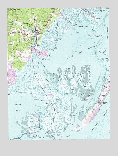
Tuckerton, NJ USGS Topographic Map
Click on map above to begin viewing in our Map Viewer.

This topographic map contains these locations and features:
Feature Name Type Latitude Longitude GNIS ID View Map
Barrel ChannelChannelN39.5568°W74.2804°874514View Map
Barrel IslandIslandN39.5579°W74.2743°874515View Map
Beach Haven HeightsPopulated PlaceN39.5346°W74.2604°874572View Map
Big CreekStreamN39.5457°W74.3645°874745View Map
Big Sheepshead CreekGutN39.5365°W74.3096°874760View Map
Big ThorofareStreamN39.5653°W74.3423°874763View Map
Borough of TuckertonCivilN39.5973°W74.3305°885422View Map
Bunting SedgeIslandN39.5515°W74.2788°875031View Map
Bureau of Fire SafetyBuildingN39.6042°W74.3568°2401566View Map
Cape HornCapeN39.5385°W74.3379°875186View Map
Coastal Learning Center Day SchoolSchoolN39.6126°W74.3237°2333215View Map
Dinner PointCapeN39.6232°W74.2560°875923View Map
Dinner Point CreekStreamN39.6225°W74.2602°875924View Map
Drag SedgeIslandN39.5618°W74.3038°875965View Map
East SedgeIslandN39.5690°W74.2763°876066View Map
Edge CoveBayN39.5948°W74.3154°876095View Map
Edwin B Forsythe National Wildlife RefugeParkN39.6147°W74.3102°873917View Map
Fish IslandIslandN39.5090°W74.3454°876351View Map
Flatteras CreekStreamN39.5210°W74.3073°876382View Map
Foxboro PointCapeN39.5376°W74.2985°876456View Map
Gaunt PointCapeN39.5765°W74.3260°876576View Map
George J Mitchell Elementary SchoolSchoolN39.6201°W74.3427°2045929View Map
Giffords Mill BranchStreamN39.6067°W74.3523°876604View Map
GiffordtownPopulated PlaceN39.6004°W74.3718°876605View Map
Goodluck SedgeIslandN39.5468°W74.2943°876669View Map
Goosebar CutChannelN39.5443°W74.2790°876680View Map
Goosebar SedgeIslandN39.5401°W74.2760°876681View Map
Great Bay Boulevard State Wildlife Management AreaParkN39.5335°W74.3079°883041View Map
Great Bay Regional Volunteer Emergency Medical ServicesBuildingN39.5968°W74.3549°2401943View Map
Greenwood CemeteryCemeteryN39.6115°W74.3401°876812View Map
Hatfield CreekStreamN39.5103°W74.3313°876989View Map
Hatfield PointCapeN39.5112°W74.3321°876990View Map
Hester SedgeIslandN39.5662°W74.3013°877068View Map
Hither ChannelChannelN39.5554°W74.3013°877144View Map
Hither IslandIslandN39.5562°W74.2960°877145View Map
HolgatePopulated PlaceN39.5401°W74.2568°877165View Map
Horse Foot CoveBayN39.5546°W74.3232°877256View Map
Jeremy PointCapeN39.5871°W74.3154°877446View Map
Jesses CreekStreamN39.5970°W74.3109°877454View Map
Jessie PointCapeN39.5957°W74.3110°877455View Map
Jimmies CreekGutN39.5476°W74.3271°877457View Map
Johnny SedgeIslandN39.5585°W74.2846°877469View Map
Johnny ThorofareChannelN39.5590°W74.2863°877470View Map
Little Egg HarborBayN39.5901°W74.2729°877833View Map
Little Egg Harbor Township Police DepartmentBuildingN39.5761°W74.3637°2730764View Map
Little IslandIslandN39.5771°W74.2518°877843View Map
Little Sheepshead CreekGutN39.5240°W74.3143°877860View Map
Little ThorofareChannelN39.5521°W74.3376°877865View Map
Long PointCapeN39.5985°W74.2621°877921View Map
Long Point ThorofareChannelN39.6035°W74.2665°877925View Map
Marshelder ChannelChannelN39.5448°W74.3104°878151View Map
Marshelder PointCapeN39.5521°W74.3188°878154View Map
Middle ChannelChannelN39.5568°W74.2918°878295View Map
Middle IslandIslandN39.5615°W74.2882°878296View Map
Middle SedgeIslandN39.5654°W74.2751°878301View Map
Mill BranchStreamN39.6050°W74.3463°878338View Map
Mordecai IslandIslandN39.5587°W74.2521°878473View Map
Mystic Island Volunteer Fire Department Station 72BuildingN39.5743°W74.3682°2401942View Map
Newmans ThorofareChannelN39.5182°W74.3351°878782View Map
NugentownPopulated PlaceN39.6115°W74.3554°878896View Map
Ocean County Golf Course at AtlantisLocaleN39.5771°W74.3563°2045942View Map
Parker CoveBayN39.6071°W74.2813°879124View Map
Parker IslandIslandN39.5590°W74.3179°879125View Map
Parker RunStreamN39.6089°W74.2921°879128View Map
Parkers LandingPopulated PlaceN39.5898°W74.3393°879132View Map
Parkertown County ParkParkN39.6098°W74.2918°2047141View Map
Pinelands Regional High SchoolSchoolN39.6105°W74.3593°2045931View Map
Pinelands Regional Junior High SchoolSchoolN39.6142°W74.3605°2045932View Map
Pohatcong LakeReservoirN39.6044°W74.3451°884313View Map
Point CreekGutN39.5123°W74.3074°874230View Map
Pole ThorofareChannelN39.5062°W74.3471°879404View Map
Pulaski MonumentParkN39.5729°W74.3693°879545View Map
Rose CoveBayN39.6004°W74.3068°879808View Map
Rose PointCapeN39.6026°W74.2910°879814View Map
Sapp CreekStreamN39.5937°W74.3160°880266View Map
Scow LandingPopulated PlaceN39.5982°W74.3396°880437View Map
Seven IslandsIslandN39.5187°W74.3454°880478View Map
Shelter IslandIslandN39.5832°W74.2549°880541View Map
Shooting ThorofareChannelN39.5051°W74.3190°880574View Map
Sloop ThorofareChannelN39.5112°W74.3474°880648View Map
Soldiers HoleChannelN39.5498°W74.2976°880679View Map
Story IslandIslandN39.5504°W74.3043°880953View Map
Story Island ChannelChannelN39.5576°W74.3110°880954View Map
Thompson CreekStreamN39.5987°W74.3143°881162View Map
Thorofare PointCapeN39.5690°W74.3379°881169View Map
Tow IslandIslandN39.5040°W74.3410°881216View Map
Township of Little Egg HarborCivilN39.5430°W74.3365°882067View Map
Tuckers IslandCapeN39.5126°W74.2885°882697View Map
TuckertonPopulated PlaceN39.6032°W74.3401°881282View Map
Tuckerton BayBayN39.5826°W74.3204°881283View Map
Tuckerton Borough Police DepartmentBuildingN39.6126°W74.3237°2730724View Map
Tuckerton CoveBayN39.5751°W74.3354°881284View Map
Tuckerton CreekStreamN39.5771°W74.3376°881285View Map
Tuckerton Elementary SchoolSchoolN39.6017°W74.3365°2052846View Map
Tuckerton Fire DepartmentBuildingN39.6040°W74.3399°2401642View Map
Tuckerton ShoresPopulated PlaceN39.6071°W74.3249°2047023View Map
WACI-TV (Atlantic City)TowerN39.6135°W74.2635°884634View Map
Weir CreekStreamN39.6117°W74.2847°881653View Map
West SedgeIslandN39.5676°W74.2807°881726View Map
West TuckertonPopulated PlaceN39.6015°W74.3535°881732View Map
West Tuckerton LandingPopulated PlaceN39.5960°W74.3421°881733View Map
West Tuckerton Volunteer Fire Company Station 71BuildingN39.6021°W74.3580°2401792View Map
Westecunk CreekStreamN39.6160°W74.2640°881738View Map
Whirlpool PointCapeN39.5243°W74.3332°881774View Map
Willis CreekStreamN39.5762°W74.3393°881849View Map

Note: Coordinates in the location and feature list above are referenced to NAD83 datum.


Copyright (C) 2008-2024 Ryan Niemi / Sunset Dynamics ... All Rights Reserved