TopoQuest Logo
Do you find TopoQuest useful?
Help keep TopoQuest running and adding new maps/features by donating!
Bitcoin:  19c7KJd3qBynnjoSw5npx9KScwjBe4ifkT
Litecoin:  LXs6TkuXGGXo1vDsWCkWVdjQX94eUKd6ui
Home View Maps Find Maps Find Places Resources & Links


Brigantine Inlet, New Jersey Topographic Map

USGS Map Title: Brigantine Inlet, NJ
USGS Map MRC: 39074D3
DRG (GeoTIFF) Download: o39074d3.tif


Neighboring USGS Topographic Map Quads:


  New Gretna, NJ  
39074E4
 

  Tuckerton, NJ  
39074E3
 

  Beach Haven, NJ  
39074E2
 

  Oceanville, NJ  
39074D4
 

  Brigantine Inlet, NJ  
39074D3


  Atlantic City, NJ  
39074C4


Map MRC Location:

N40°
W75°
N40°
W74°
H8 H7 H6 H5 H4 H3 H2 H1
G8 G7 G6 G5 G4 G3 G2 G1
F8 F7 F6 F5 F4 F3 F2 F1
E8 E7 E6 E5 E4 E3 E2 E1
D8 D7 D6 D5 D4 D3 D2 D1
C8 C7 C6 C5 C4 C3 C2 C1
B8 B7 B6 B5 B4 B3 B2 B1
A8 A7 A6 A5 A4 A3 A2 A1
N39°
W75°
N39°
W74°

Brigantine Inlet, NJ USGS 1:24K Topographic Map Preview:
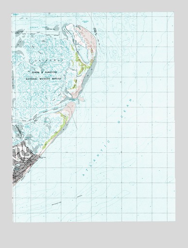
Brigantine Inlet, NJ USGS Topographic Map
Click on map above to begin viewing in our Map Viewer.

This topographic map contains these locations and features:
Feature Name Type Latitude Longitude GNIS ID View Map
Baremore QuartersBayN39.4087°W74.3710°874494View Map
Betsey ChannelChannelN39.4415°W74.3688°874732View Map
BrigantinePopulated PlaceN39.4101°W74.3646°874936View Map
Brigantine Beach PatrolBuildingN39.3985°W74.3729°2730787View Map
Brigantine Central SchoolSchoolN39.4029°W74.3740°874117View Map
Brigantine Central SchoolSchoolN39.4032°W74.3740°873959View Map
Brigantine ChannelChannelN39.4387°W74.3571°874938View Map
Brigantine City HallBuildingN39.4021°W74.3738°873955View Map
Brigantine Country ClubLocaleN39.4207°W74.3724°874115View Map
Brigantine Country ClubLocaleN39.4207°W74.3696°873956View Map
Brigantine Fire DepartmentBuildingN39.4021°W74.3733°2401690View Map
Brigantine InletBayN39.4465°W74.3263°874939View Map
Brigantine North SchoolSchoolN39.4110°W74.3646°874116View Map
Brigantine North SchoolSchoolN39.4110°W74.3646°873958View Map
Brigantine Police DepartmentBuildingN39.4021°W74.3736°2730573View Map
Brigantine ShoalBarN39.3876°W74.3346°874941View Map
Cabbage ThorofareChannelN39.4790°W74.3315°875072View Map
Dog IslandIslandN39.4910°W74.3310°875937View Map
Egg IslandIslandN39.4773°W74.3554°876121View Map
Elder IslandIslandN39.4501°W74.3393°876136View Map
Fourteenth Street PierLocaleN39.4135°W74.3535°876442View Map
Great ThorofareChannelN39.4748°W74.3374°876759View Map
Hoffman PointCapeN39.4354°W74.3585°873960View Map
Hoffman ThorofareChannelN39.4268°W74.3660°877154View Map
Island BeachBeachN39.4823°W74.3263°877822View Map
Little BeachBeachN39.4793°W74.3251°874113View Map
Little BeachLocaleN39.4798°W74.3265°873957View Map
Little Crooked ThorofareChannelN39.4623°W74.3485°877830View Map
Little Egg InletBayN39.4982°W74.3174°877834View Map
Little Mud ThorofareChannelN39.4546°W74.3551°877850View Map
Little Weakfish ThorofareChannelN39.4310°W74.3518°877869View Map
Mile ThorofareChannelN39.4785°W74.3479°878331View Map
Mud ThorofareChannelN39.4490°W74.3590°878639View Map
Pullen IslandIslandN39.4576°W74.3254°879549View Map
Salt IslandIslandN39.4818°W74.3440°880241View Map
Simkins ThorofareChannelN39.4662°W74.3626°880616View Map
Somers BayBayN39.4279°W74.3738°880688View Map
Steelman BayBayN39.4235°W74.3638°880867View Map
Weakfish ThorofareChannelN39.4268°W74.3540°881637View Map
Widgeon BayBayN39.4362°W74.3471°881821View Map

Note: Coordinates in the location and feature list above are referenced to NAD83 datum.


Copyright (C) 2008-2025 Ryan Niemi / Sunset Dynamics ... All Rights Reserved