TopoQuest Logo
Do you find TopoQuest useful?
Help keep TopoQuest running and adding new maps/features by donating!
Bitcoin:  19c7KJd3qBynnjoSw5npx9KScwjBe4ifkT
Litecoin:  LXs6TkuXGGXo1vDsWCkWVdjQX94eUKd6ui
Home View Maps Find Maps Find Places Resources & Links


Tygarts Valley, Kentucky Topographic Map

USGS Map Title: Tygarts Valley, KY
USGS Map MRC: 38083D1
DRG (GeoTIFF) Download: o38083d1.tif


Neighboring USGS Topographic Map Quads:


  Garrison, KY  
38083E2
 

  Brushart, KY  
38083E1
 

  Load, KY  
38082E8
 

  Wesleyville, KY  
38083D2
 

  Tygarts Valley, KY  
38083D1
 

  Oldtown, KY  
38082D8
 

  Olive Hill, KY  
38083C2
 

  Grahn, KY  
38083C1
 

  Grayson, KY  
38082C8


Map MRC Location:

N39°
W84°
N39°
W83°
H8 H7 H6 H5 H4 H3 H2 H1
G8 G7 G6 G5 G4 G3 G2 G1
F8 F7 F6 F5 F4 F3 F2 F1
E8 E7 E6 E5 E4 E3 E2 E1
D8 D7 D6 D5 D4 D3 D2 D1
C8 C7 C6 C5 C4 C3 C2 C1
B8 B7 B6 B5 B4 B3 B2 B1
A8 A7 A6 A5 A4 A3 A2 A1
N38°
W84°
N38°
W83°

Tygarts Valley, KY USGS 1:24K Topographic Map Preview:
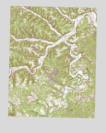
Tygarts Valley, KY USGS Topographic Map
Click on map above to begin viewing in our Map Viewer.

This topographic map contains these locations and features:
Feature Name Type Latitude Longitude GNIS ID View Map
Adams CreekStreamN38.3856°W83.0649°485772View Map
Backs BranchStreamN38.4537°W83.0332°486191View Map
Barnes BranchStreamN38.4309°W83.1152°486379View Map
Bentley CemeteryCemeteryN38.4006°W83.0493°486885View Map
Blair HollowValleyN38.4638°W83.1005°487440View Map
Boone FurnacePopulated PlaceN38.4667°W83.1232°507552View Map
Buffalo CreekStreamN38.4648°W83.0513°488320View Map
Burnett CemeteryCemeteryN38.4087°W83.0263°488443View Map
CarterPopulated PlaceN38.4290°W83.1207°488989View Map
Carter City Volunteer Fire DepartmentBuildingN38.4295°W83.1239°2637252View Map
Charlotte FurnacePopulated PlaceN38.4117°W83.0332°507687View Map
Clark BranchStreamN38.4017°W83.0441°489527View Map
Colen BranchStreamN38.4637°W83.0888°489828View Map
Davis CemeteryCemeteryN38.4123°W83.0277°490655View Map
DeevertPopulated PlaceN38.3845°W83.0424°507836View Map
Elk LickStreamN38.3765°W83.0780°491663View Map
Everman CemeteryCemeteryN38.4545°W83.0649°491853View Map
Friends BranchStreamN38.4104°W83.0427°492536View Map
GeslingPopulated PlaceN38.4231°W83.0924°508082View Map
Grassy CreekStreamN38.4565°W83.0632°493153View Map
Grizzle HollowValleyN38.4762°W83.0622°493412View Map
Harvey BranchStreamN38.4567°W83.0680°493847View Map
Horn HollowValleyN38.3752°W83.1154°494559View Map
Huffman CemeteryCemeteryN38.4109°W83.0263°494740View Map
Hurricane BranchStreamN38.4470°W83.0366°494813View Map
Iron HillPopulated PlaceN38.4062°W83.0380°508317View Map
KehoePopulated PlaceN38.4662°W83.0513°508373View Map
Leatherwood BranchStreamN38.4854°W83.0282°496121View Map
Little Leatherwood BranchStreamN38.4881°W83.0413°496782View Map
Old She HollowValleyN38.4950°W83.0102°499885View Map
Plummer ChurchChurchN38.3792°W83.1016°500979View Map
Potato KnobSummitN38.3831°W83.0343°501189View Map
Praise God Airport (historical)AirportN38.4440°W83.1234°517352View Map
Ramey BranchStreamN38.4487°W83.0702°501550View Map
Robertson FlatFlatN38.4634°W83.0321°502076View Map
Rock Springs BranchStreamN38.4340°W83.0777°502149View Map
Ross BranchStreamN38.4245°W83.0360°502361View Map
Sand RidgeRidgeN38.4134°W83.1230°502934View Map
Shaws BranchStreamN38.4442°W83.0255°503297View Map
Slash HollowValleyN38.4809°W83.0047°503630View Map
Slate LickStreamN38.3776°W83.1013°503653View Map
Smith CreekStreamN38.4306°W83.1205°503783View Map
South Fork Clark BranchStreamN38.4029°W83.0507°503917View Map
Stumps RunStreamN38.3990°W83.0196°504610View Map
Sutton BranchStreamN38.3837°W83.0693°504819View Map
Thomas BranchStreamN38.4634°W83.0924°505157View Map
Three Prong BranchStreamN38.4676°W83.0505°505240View Map
Turkeypen ForkStreamN38.4952°W83.0982°505642View Map
Tygarts ValleyPopulated PlaceN38.4817°W83.0318°509255View Map
Whitehouse HollowValleyN38.4683°W83.1247°506659View Map
WolfPopulated PlaceN38.3792°W83.0993°509396View Map
Wolf CreekStreamN38.4776°W83.0005°507003View Map
Wolf Post OfficePost OfficeN38.3901°W83.1093°517540View Map
Wolfpen CreekStreamN38.3779°W83.0807°507063View Map
Zornes BranchStreamN38.4412°W83.0799°507309View Map
Zornes CemeteryCemeteryN38.4351°W83.0802°507310View Map

Note: Coordinates in the location and feature list above are referenced to NAD83 datum.


Copyright (C) 2008-2024 Ryan Niemi / Sunset Dynamics ... All Rights Reserved