TopoQuest Logo
Do you find TopoQuest useful?
Help keep TopoQuest running and adding new maps/features by donating!
Bitcoin:  19c7KJd3qBynnjoSw5npx9KScwjBe4ifkT
Litecoin:  LXs6TkuXGGXo1vDsWCkWVdjQX94eUKd6ui
Home View Maps Find Maps Find Places Resources & Links


Wesleyville, Kentucky Topographic Map

USGS Map Title: Wesleyville, KY
USGS Map MRC: 38083D2
DRG (GeoTIFF) Download: o38083d2.tif


Neighboring USGS Topographic Map Quads:


  Vanceburg, KY  
38083E3
 

  Garrison, KY  
38083E2
 

  Brushart, KY  
38083E1
 

  Head of Grassy, KY  
38083D3
 

  Wesleyville, KY  
38083D2
 

  Tygarts Valley, KY  
38083D1
 

  Soldier, KY  
38083C3
 

  Olive Hill, KY  
38083C2
 

  Grahn, KY  
38083C1


Map MRC Location:

N39°
W84°
N39°
W83°
H8 H7 H6 H5 H4 H3 H2 H1
G8 G7 G6 G5 G4 G3 G2 G1
F8 F7 F6 F5 F4 F3 F2 F1
E8 E7 E6 E5 E4 E3 E2 E1
D8 D7 D6 D5 D4 D3 D2 D1
C8 C7 C6 C5 C4 C3 C2 C1
B8 B7 B6 B5 B4 B3 B2 B1
A8 A7 A6 A5 A4 A3 A2 A1
N38°
W84°
N38°
W83°

Wesleyville, KY USGS 1:24K Topographic Map Preview:
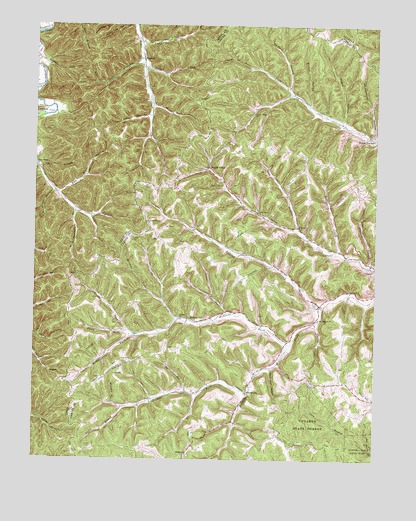
Wesleyville, KY USGS Topographic Map
Click on map above to begin viewing in our Map Viewer.

This topographic map contains these locations and features:
Feature Name Type Latitude Longitude GNIS ID View Map
Amey CemeteryCemeteryN38.4037°W83.2182°485925View Map
Bethel ChurchChurchN38.3765°W83.1935°486990View Map
Big RunStreamN38.3945°W83.1938°487242View Map
Bone Hole HollowValleyN38.4017°W83.1629°487663View Map
Boone ChurchChurchN38.4680°W83.1257°2337843View Map
Boone Furnace (historical)LocaleN38.4684°W83.1259°2337207View Map
Boone Furnace School (historical)SchoolN38.4680°W83.1283°2337343View Map
Bruce HollowValleyN38.4773°W83.1493°488052View Map
Brushy CreekStreamN38.4190°W83.1438°488107View Map
Brushy School (historical)SchoolN38.4343°W83.1729°2337345View Map
Carter DivisionCivilN38.4220°W83.1365°1936922View Map
Cedar RunStreamN38.4876°W83.2102°489243View Map
Cedar RunStreamN38.4176°W83.1793°489244View Map
Cooper CemeteryCemeteryN38.4384°W83.2146°490051View Map
Davis ForkStreamN38.4106°W83.2127°490667View Map
Deep CutGapN38.4567°W83.2010°2337193View Map
EbyPopulated PlaceN38.4390°W83.2043°507903View Map
Fox HollowValleyN38.4588°W83.2484°492412View Map
Fults CemeteryCemeteryN38.3779°W83.2291°492620View Map
Halfway BranchStreamN38.4317°W83.1263°493562View Map
Halls ForkStreamN38.4806°W83.1566°493603View Map
Jessie BranchStreamN38.3895°W83.2171°495250View Map
Jordan CemeteryCemeteryN38.4615°W83.1507°495527View Map
Jordan ForkStreamN38.3940°W83.1707°495529View Map
Jordan Fork School (historical)SchoolN38.3921°W83.2072°2337348View Map
Katy Cooper BranchStreamN38.4517°W83.2432°495578View Map
Kibbey ChurchChurchN38.4162°W83.1966°495714View Map
Kiser CemeteryCemeteryN38.4192°W83.1468°495811View Map
Lambert HollowValleyN38.4947°W83.2110°495939View Map
Lick BranchStreamN38.4412°W83.1538°496445View Map
Long ForkStreamN38.4151°W83.1968°497107View Map
McGlone ForkStreamN38.4084°W83.1568°497867View Map
McGlone Fork School (historical)SchoolN38.4116°W83.2091°2337349View Map
Meadows ForkStreamN38.4212°W83.2030°497999View Map
Mount Pleasant ChurchChurchN38.4156°W83.1455°498851View Map
Murphy BranchStreamN38.3909°W83.2205°499109View Map
Negro HollowValleyN38.4727°W83.1368°499242View Map
Oakland ChurchChurchN38.3970°W83.1482°499741View Map
Oakland School (historical)SchoolN38.3986°W83.1377°2337346View Map
Perry ForkStreamN38.4120°W83.2152°500428View Map
Polly Moore BranchStreamN38.4740°W83.2080°501017View Map
PoplarPopulated PlaceN38.4420°W83.1530°508851View Map
Red Buck HollowValleyN38.4516°W83.2410°501643View Map
Reeder ForkStreamN38.4448°W83.2296°501698View Map
Road Fork HollowValleyN38.4771°W83.2069°502028View Map
Road Post Office (historical)Post OfficeN38.3907°W83.2174°2337268View Map
RooneyPopulated PlaceN38.4151°W83.1907°508966View Map
RuglessPopulated PlaceN38.4895°W83.2105°508986View Map
Rugless Post Office (historical)Post OfficeN38.4899°W83.2107°2363060View Map
Saint Paul HollowValleyN38.4819°W83.1572°502714View Map
Scott Branch ChurchChurchN38.4598°W83.2496°503089View Map
Scott Branch School (historical)SchoolN38.4595°W83.2494°2363069View Map
Scott HollowValleyN38.4140°W83.1462°503102View Map
Sexton CemeteryCemeteryN38.4540°W83.1816°503195View Map
Smith Creek ChurchChurchN38.4462°W83.1682°503785View Map
Smith Creek School (historical)SchoolN38.4514°W83.1769°2337344View Map
Smiths CreekPopulated PlaceN38.4587°W83.1860°509085View Map
Smiths Creek Post Office (historical)Post OfficeN38.4594°W83.1864°2337266View Map
Stafford Hill SchoolSchoolN38.4431°W83.2091°504226View Map
Staffords HillSummitN38.4446°W83.2093°2337370View Map
Stone BranchStreamN38.4909°W83.2110°504445View Map
Stone Branch Railroad Station (historical)LocaleN38.4906°W83.2109°2363073View Map
Tygarts State ForestForestN38.3856°W83.1488°505738View Map
Upper Grassy SchoolSchoolN38.4745°W83.1702°505883View Map
Wash Broomfield BranchStreamN38.4462°W83.2355°506408View Map
WesleyvillePopulated PlaceN38.3948°W83.1716°509339View Map
Wesleyville ChurchChurchN38.3955°W83.1737°2337844View Map
Wesleyville School (historical)SchoolN38.3945°W83.1723°2337347View Map
Wolfpen CreekStreamN38.4354°W83.1380°507064View Map
Womstead FieldAirportN38.3787°W83.1568°2444098View Map

Note: Coordinates in the location and feature list above are referenced to NAD83 datum.


Copyright (C) 2008-2024 Ryan Niemi / Sunset Dynamics ... All Rights Reserved