TopoQuest Logo
Do you find TopoQuest useful?
Help keep TopoQuest running and adding new maps/features by donating!
Bitcoin:  19c7KJd3qBynnjoSw5npx9KScwjBe4ifkT
Litecoin:  LXs6TkuXGGXo1vDsWCkWVdjQX94eUKd6ui
Home View Maps Find Maps Find Places Resources & Links


Tyner, New York Topographic Map

USGS Map Title: Tyner, NY
USGS Map MRC: 42075D6
DRG (GeoTIFF) Download: o42075d6.tif


Neighboring USGS Topographic Map Quads:


  Pitcher, NY  
42075E7
 

  East Pharsalia, NY  
42075E6
 

  Norwich, NY  
42075E5
 

  Smithville Flats, NY  
42075D7
 

  Tyner, NY  
42075D6
 

  Oxford, NY  
42075D5
 

  Greene, NY  
42075C7
 

  Brisben, NY  
42075C6
 

  West Bainbridge, NY  
42075C5


Map MRC Location:

N43°
W76°
N43°
W75°
H8 H7 H6 H5 H4 H3 H2 H1
G8 G7 G6 G5 G4 G3 G2 G1
F8 F7 F6 F5 F4 F3 F2 F1
E8 E7 E6 E5 E4 E3 E2 E1
D8 D7 D6 D5 D4 D3 D2 D1
C8 C7 C6 C5 C4 C3 C2 C1
B8 B7 B6 B5 B4 B3 B2 B1
A8 A7 A6 A5 A4 A3 A2 A1
N42°
W76°
N42°
W75°

Tyner, NY USGS 1:24K Topographic Map Preview:
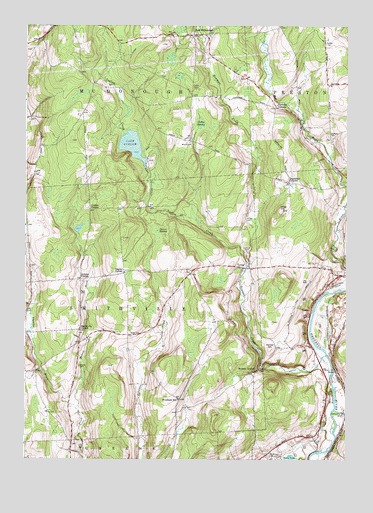
Tyner, NY USGS Topographic Map
Click on map above to begin viewing in our Map Viewer.

This topographic map contains these locations and features:
Feature Name Type Latitude Longitude GNIS ID View Map
Adams CornerPopulated PlaceN42.4267°W75.7282°972150View Map
Bear BrookStreamN42.3892°W75.6294°943250View Map
Beardsley CemeteryCemeteryN42.4539°W75.6420°2559166View Map
Bowman CreekStreamN42.4051°W75.6327°944525View Map
Buckley HollowPopulated PlaceN42.4009°W75.6602°972275View Map
Corbin CemeteryCemeteryN42.4823°W75.6850°947429View Map
Corbin CornerPopulated PlaceN42.4470°W75.7252°972344View Map
Corbin SwampSwampN42.4714°W75.6813°947435View Map
Cowles CemeteryCemeteryN42.4018°W75.7291°947600View Map
Curtis CemeteryCemeteryN42.4949°W75.6335°947959View Map
Dibble CornerPopulated PlaceN42.4287°W75.7116°972382View Map
East McDonoughPopulated PlaceN42.4973°W75.6855°972424View Map
Eddy BrookStreamN42.3890°W75.6257°949356View Map
Edgerton BrookStreamN42.3876°W75.7282°949373View Map
Ingraham CornersLocaleN42.4551°W75.6477°953723View Map
Kedron BrookStreamN42.3876°W75.7282°954425View Map
Lake LudlowLakeN42.4655°W75.7088°956144View Map
Loomis CemeteryCemeteryN42.4351°W75.6644°955961View Map
Ludlow CreekStreamN42.4306°W75.6641°956142View Map
Miller CemeteryCemeteryN42.4109°W75.7062°957299View Map
Miller HillSummitN42.4470°W75.6505°957311View Map
Moore CemeteryCemeteryN42.4666°W75.6863°957594View Map
Nortons CornersLocaleN42.4765°W75.6532°959016View Map
Painter HillSummitN42.4067°W75.6546°959765View Map
Smithville CenterPopulated PlaceN42.4123°W75.7282°973081View Map
Spruce SwampSwampN42.4404°W75.6989°966147View Map
Stafford CemeteryCemeteryN42.4687°W75.6297°966199View Map
Ten Broeck CemeteryCemeteryN42.3762°W75.6550°967152View Map
Towsley and Pond CemeteryCemeteryN42.4228°W75.7284°960887View Map
TynerPopulated PlaceN42.4304°W75.6655°968102View Map
Wilcox CemeteryCemeteryN42.4439°W75.6639°971239View Map
Windham SchoolSchoolN42.3923°W75.6896°971465View Map

Note: Coordinates in the location and feature list above are referenced to NAD83 datum.


Copyright (C) 2008-2025 Ryan Niemi / Sunset Dynamics ... All Rights Reserved