TopoQuest Logo
Do you find TopoQuest useful?
Help keep TopoQuest running and adding new maps/features by donating!
Bitcoin:  19c7KJd3qBynnjoSw5npx9KScwjBe4ifkT
Litecoin:  LXs6TkuXGGXo1vDsWCkWVdjQX94eUKd6ui
Home View Maps Find Maps Find Places Resources & Links


Oxford, New York Topographic Map

USGS Map Title: Oxford, NY
USGS Map MRC: 42075D5
DRG (GeoTIFF) Download: o42075d5.tif


Neighboring USGS Topographic Map Quads:


  East Pharsalia, NY  
42075E6
 

  Norwich, NY  
42075E5
 

  Holmesville, NY  
42075E4
 

  Tyner, NY  
42075D6
 

  Oxford, NY  
42075D5
 

  Guilford, NY  
42075D4
 

  Brisben, NY  
42075C6
 

  West Bainbridge, NY  
42075C5
 

  Sidney, NY  
42075C4


Map MRC Location:

N43°
W76°
N43°
W75°
H8 H7 H6 H5 H4 H3 H2 H1
G8 G7 G6 G5 G4 G3 G2 G1
F8 F7 F6 F5 F4 F3 F2 F1
E8 E7 E6 E5 E4 E3 E2 E1
D8 D7 D6 D5 D4 D3 D2 D1
C8 C7 C6 C5 C4 C3 C2 C1
B8 B7 B6 B5 B4 B3 B2 B1
A8 A7 A6 A5 A4 A3 A2 A1
N42°
W76°
N42°
W75°

Oxford, NY USGS 1:24K Topographic Map Preview:
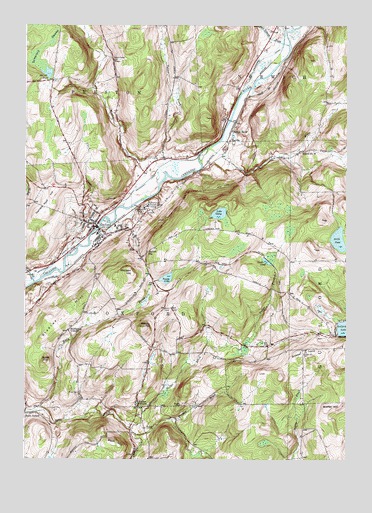
Oxford, NY USGS Topographic Map
Click on map above to begin viewing in our Map Viewer.

This topographic map contains these locations and features:
Feature Name Type Latitude Longitude GNIS ID View Map
Bethel Church (historical)ChurchN42.4383°W75.5936°2374562View Map
Blackman CemeteryCemeteryN42.4592°W75.5804°2559170View Map
Blue Stone Golf CourseLocaleN42.4514°W75.5967°2615348View Map
Bradley HillSummitN42.4173°W75.6099°944579View Map
Breffel HillSummitN42.3895°W75.5068°944687View Map
Brooks CemeteryCemeteryN42.3906°W75.5642°944854View Map
Burnt HillSummitN42.4037°W75.6166°945245View Map
Chenango CountyCivilN42.4935°W75.6116°974107View Map
Cheshire CreekStreamN42.3823°W75.5819°946537View Map
Clark CreekStreamN42.4426°W75.5960°946754View Map
Coventry StationLocaleN42.3881°W75.6249°947575View Map
Faith Bible ChurchChurchN42.4498°W75.6057°2615906View Map
First Congregational ChurchChurchN42.4411°W75.5950°2374559View Map
Fly Meadow CreekStreamN42.4570°W75.5707°970134View Map
Gamble Roof HillSummitN42.4504°W75.6160°950867View Map
Gilmore BrookStreamN42.4945°W75.5224°951135View Map
Gospel HillSummitN42.4062°W75.5168°951407View Map
Gospel Hill CemeteryCemeteryN42.4060°W75.5154°951408View Map
HaynesPopulated PlaceN42.4670°W75.5457°972609View Map
Kingdom Hall of Jehovahs WitnessesChurchN42.4892°W75.5355°2616571View Map
Lake GerryLakeN42.4456°W75.5488°951047View Map
Lyon BrookStreamN42.4648°W75.5544°956185View Map
Many Maples FarmLocaleN42.4939°W75.5919°2556824View Map
Mason - Packer CemeteryCemeteryN42.4897°W75.5906°956641View Map
McCall PondLakeN42.4863°W75.6162°956727View Map
Mead CemeteryCemeteryN42.3942°W75.6040°956859View Map
Midland HillSummitN42.4290°W75.5835°957163View Map
Mill BrookStreamN42.4259°W75.6213°957204View Map
Millbrook CemeteryCemeteryN42.4293°W75.6230°2559171View Map
Moore CemeteryCemeteryN42.4090°W75.5742°2559167View Map
Mowry HillSummitN42.4134°W75.5782°957973View Map
New York State Veterans Home CemeteryCemeteryN42.4463°W75.5775°2559168View Map
New York State Veterans Home of OxfordBuildingN42.4492°W75.5749°2614732View Map
North PondLakeN42.4384°W75.5028°958884View Map
Northrups CornersLocaleN42.4120°W75.6080°958978View Map
OxfordPopulated PlaceN42.4420°W75.5977°959713View Map
Oxford - McDonough United Methodist ChurchChurchN42.4392°W75.6021°2616204View Map
Oxford Academy And Central SchoolSchoolN42.4400°W75.5967°2374556View Map
Oxford Academy High SchoolSchoolN42.4409°W75.6056°2669235View Map
Oxford Academy Primary SchoolSchoolN42.4403°W75.6065°2668886View Map
Oxford Baptist ChurchChurchN42.4408°W75.5961°2374558View Map
Oxford Fire DepartmentBuildingN42.4410°W75.5962°2374560View Map
Oxford Memorial LibraryBuildingN42.4408°W75.5964°2374557View Map
Oxford Post OfficePost OfficeN42.4424°W75.5988°2618052View Map
Oxford StationLocaleN42.4345°W75.5777°959714View Map
Padget BrookStreamN42.3840°W75.5835°959742View Map
Riverview CemeteryCemeteryN42.4425°W75.5848°2559169View Map
Rounds CemeteryCemeteryN42.3842°W75.5766°963035View Map
Roys HillSummitN42.3795°W75.5896°963064View Map
Saint Joseph CemeteryCemeteryN42.4429°W75.6057°2559172View Map
Saint Joseph's Roman Catholic ChurchChurchN42.4433°W75.6003°2374561View Map
Saint Pauls Episcopal ChurchChurchN42.4397°W75.5936°2374564View Map
School Number 13 (historical)SchoolN42.4695°W75.5446°975051View Map
School Number 16 (historical)SchoolN42.4640°W75.5168°975119View Map
Shapley BrookStreamN42.3823°W75.5819°964942View Map
South OxfordPopulated PlaceN42.3881°W75.6213°973097View Map
State Street BridgeBridgeN42.4416°W75.5964°2614995View Map
Tamarack SwampSwampN42.4881°W75.6182°967022View Map
Tank PondLakeN42.4322°W75.5309°967036View Map
Temple Baptist ChurchChurchN42.4819°W75.5439°2616308View Map
Town of OxfordCivilN42.4002°W75.5911°979335View Map
Trestle LakeReservoirN42.4271°W75.5698°967796View Map
Turner CreekStreamN42.4617°W75.5749°967973View Map
Van Wagenen CemeteryCemeteryN42.4464°W75.5792°968434View Map
Village CemeteryCemeteryN42.4434°W75.6022°2559173View Map
Village of OxfordCivilN42.4412°W75.5959°2391046View Map
Walker CornersLocaleN42.3901°W75.5807°968680View Map
Washington ParkParkN42.4397°W75.5922°2374563View Map
Womans Relief Corps HomeBuildingN42.4481°W75.5777°971589View Map

Note: Coordinates in the location and feature list above are referenced to NAD83 datum.


Copyright (C) 2008-2025 Ryan Niemi / Sunset Dynamics ... All Rights Reserved