TopoQuest Logo
Do you find TopoQuest useful?
Help keep TopoQuest running and adding new maps/features by donating!
Bitcoin:  19c7KJd3qBynnjoSw5npx9KScwjBe4ifkT
Litecoin:  LXs6TkuXGGXo1vDsWCkWVdjQX94eUKd6ui
Home View Maps Find Maps Find Places Resources & Links


East Pharsalia, New York Topographic Map

USGS Map Title: East Pharsalia, NY
USGS Map MRC: 42075E6
DRG (GeoTIFF) Download: o42075e6.tif


Neighboring USGS Topographic Map Quads:


  South Otselic, NY  
42075F7
 

  Otselic, NY  
42075F6
 

  Earlville, NY  
42075F5
 

  Pitcher, NY  
42075E7
 

  East Pharsalia, NY  
42075E6
 

  Norwich, NY  
42075E5
 

  Smithville Flats, NY  
42075D7
 

  Tyner, NY  
42075D6
 

  Oxford, NY  
42075D5


Map MRC Location:

N43°
W76°
N43°
W75°
H8 H7 H6 H5 H4 H3 H2 H1
G8 G7 G6 G5 G4 G3 G2 G1
F8 F7 F6 F5 F4 F3 F2 F1
E8 E7 E6 E5 E4 E3 E2 E1
D8 D7 D6 D5 D4 D3 D2 D1
C8 C7 C6 C5 C4 C3 C2 C1
B8 B7 B6 B5 B4 B3 B2 B1
A8 A7 A6 A5 A4 A3 A2 A1
N42°
W76°
N42°
W75°

East Pharsalia, NY USGS 1:24K Topographic Map Preview:
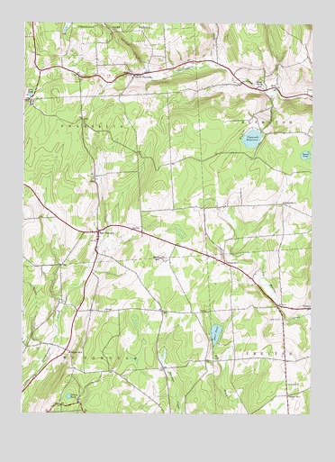
East Pharsalia, NY USGS Topographic Map
Click on map above to begin viewing in our Map Viewer.

This topographic map contains these locations and features:
Feature Name Type Latitude Longitude GNIS ID View Map
Balsam CreekStreamN42.5220°W75.7366°942946View Map
Berry HillSummitN42.5498°W75.6902°943747View Map
Bliven PondLakeN42.5054°W75.7296°944263View Map
Chenango County LandfillLocaleN42.5701°W75.6763°2668655View Map
Cole BrookStreamN42.6126°W75.6682°947096View Map
Cookhouse CreekStreamN42.6040°W75.6405°947353View Map
Deer PondReservoirN42.6019°W75.7473°948228View Map
East PharsaliaPopulated PlaceN42.5581°W75.7171°949204View Map
East Pharsalia CemeteryCemeteryN42.5564°W75.7177°2559152View Map
Frink CemeteryCemeteryN42.6146°W75.6906°950740View Map
High Meadow FarmLocaleN42.5450°W75.6486°2556818View Map
KirkPopulated PlaceN42.6048°W75.6413°972691View Map
Kirk CemeteryCemeteryN42.6106°W75.6981°2559153View Map
Lewis CemeteryCemeteryN42.5304°W75.6385°955243View Map
North PharsaliaPopulated PlaceN42.6084°W75.7016°958873View Map
Pharsalia Fire CompanyBuildingN42.5575°W75.7203°2718577View Map
Plymouth ReservoirReservoirN42.5881°W75.6510°960787View Map
Reservoir CreekStreamN42.6031°W75.6394°962395View Map
Rogers CemeteryCemeteryN42.5096°W75.6340°962816View Map
Round PondLakeN42.5830°W75.6278°962991View Map
School Number 1 (historical)SchoolN42.5059°W75.6344°974874View Map
School Number 10 (historical)SchoolN42.6053°W75.6469°974939View Map
School Number 12 (historical)SchoolN42.5676°W75.6371°975019View Map
School Number 4 (historical)SchoolN42.5556°W75.7178°2105811View Map
School Number 4 (historical)SchoolN42.5192°W75.7294°975325View Map
School Number 5 (historical)SchoolN42.5484°W75.6616°975401View Map
School Number 7 (historical)SchoolN42.6092°W75.6975°2105812View Map
Steer PondLakeN42.5258°W75.6661°966337View Map
Town of McDonoughCivilN42.5010°W75.7258°979178View Map
Town of PharsaliaCivilN42.5942°W75.7336°979360View Map

Note: Coordinates in the location and feature list above are referenced to NAD83 datum.


Copyright (C) 2008-2025 Ryan Niemi / Sunset Dynamics ... All Rights Reserved