TopoQuest Logo
Do you find TopoQuest useful?
Help keep TopoQuest running and adding new maps/features by donating!
Bitcoin:  19c7KJd3qBynnjoSw5npx9KScwjBe4ifkT
Litecoin:  LXs6TkuXGGXo1vDsWCkWVdjQX94eUKd6ui
Home View Maps Find Maps Find Places Resources & Links


Udall, Missouri Topographic Map

USGS Map Title: Udall, MO
USGS Map MRC: 36092E3
DRG (GeoTIFF) Download: o36092e3.tif


Neighboring USGS Topographic Map Quads:


  Gainesville NW, MO  
36092F4
 

  Sycamore, MO  
36092F3
 

  Cureall NW, MO  
36092F2
 

  Gainesville, MO  
36092E4
 

  Udall, MO  
36092E3
 

  Bakersfield, MO  
36092E2
 

  Midway, AR  
36092D4
 

  Clarkridge, AR  
36092D3
 

  Gamaliel, AR  
36092D2


Map MRC Location:

N37°
W93°
N37°
W92°
H8 H7 H6 H5 H4 H3 H2 H1
G8 G7 G6 G5 G4 G3 G2 G1
F8 F7 F6 F5 F4 F3 F2 F1
E8 E7 E6 E5 E4 E3 E2 E1
D8 D7 D6 D5 D4 D3 D2 D1
C8 C7 C6 C5 C4 C3 C2 C1
B8 B7 B6 B5 B4 B3 B2 B1
A8 A7 A6 A5 A4 A3 A2 A1
N36°
W93°
N36°
W92°

Udall, MO USGS 1:24K Topographic Map Preview:
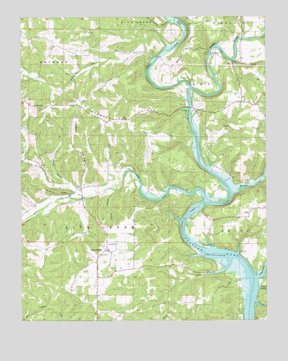
Udall, MO USGS Topographic Map
Click on map above to begin viewing in our Map Viewer.

This topographic map contains these locations and features:
Feature Name Type Latitude Longitude GNIS ID View Map
Banner School (historical)SchoolN36.5762°W92.2679°734280View Map
Big HollowValleyN36.6076°W92.2652°714177View Map
Billy Buster Ford (historical)CrossingN36.5503°W92.3429°734277View Map
Bracher RidgeRidgeN36.6115°W92.2913°714602View Map
Bratcher School (historical)SchoolN36.6223°W92.2843°733845View Map
Bridges CreekStreamN36.5523°W92.2671°714701View Map
Bridges Creek AccessLocaleN36.5578°W92.2693°741724View Map
Bryant CreekStreamN36.5962°W92.2885°735537View Map
Cane CreekStreamN36.5176°W92.2552°715340View Map
Cedar HollowValleyN36.5131°W92.2546°715608View Map
Clear Springs ChurchChurchN36.6056°W92.2671°715954View Map
Crane IslandIslandN36.6226°W92.2940°716466View Map
DawtPopulated PlaceN36.6101°W92.2768°740796View Map
Dawt MillPopulated PlaceN36.6098°W92.2782°740797View Map
Dawt Mill PondReservoirN36.6101°W92.2785°763574View Map
Dawt Mill Pond DamDamN36.6101°W92.2785°763573View Map
Dawt School (historical)SchoolN36.6037°W92.2663°733848View Map
Doc HollowValleyN36.5081°W92.2560°716931View Map
FayPopulated PlaceN36.5553°W92.3435°740578View Map
Fay CemeteryCemeteryN36.5553°W92.3452°717868View Map
Fay School (historical)SchoolN36.5548°W92.3463°733844View Map
Ford Cove AccessLocaleN36.5190°W92.2557°741725View Map
Gifford FordCrossingN36.5581°W92.3235°734278View Map
HardenvillePopulated PlaceN36.5892°W92.3713°719082View Map
Hardenville Post OfficePost OfficeN36.5888°W92.3707°2783038View Map
Howards ChurchChurchN36.5317°W92.3274°719920View Map
Howards RidgePopulated PlaceN36.5290°W92.3321°719921View Map
Howards RidgeRidgeN36.5717°W92.3493°719922View Map
Lick CreekStreamN36.5492°W92.2813°721024View Map
Lick Creek Valley Volunteer Fire DepartmentBuildingN36.5391°W92.3355°2621503View Map
Liner CreekStreamN36.5253°W92.2688°721111View Map
Liner School (historical)SchoolN36.5181°W92.2713°733847View Map
Little Pine CreekStreamN36.6116°W92.2991°721295View Map
Moore HollowValleyN36.5534°W92.3271°722578View Map
Our Saviors ChurchChurchN36.5273°W92.3357°723897View Map
Parker CemeteryCemeteryN36.6001°W92.2932°724030View Map
Pine HillSummitN36.5990°W92.2899°724378View Map
Poe Ford (historical)CrossingN36.5481°W92.2827°734281View Map
PrestoniaPopulated PlaceN36.5126°W92.3502°740577View Map
Prestonia Post Office (historical)Post OfficeN36.5126°W92.3502°759922View Map
Price Cemetery (historical)CemeteryN36.5301°W92.2799°734282View Map
Price SpringSpringN36.5312°W92.2779°724928View Map
Provo HollowValleyN36.5181°W92.2515°724978View Map
Pumphrey Ford (historical)CrossingN36.5262°W92.2649°734283View Map
Robbins RidgeRidgeN36.5528°W92.3574°725391View Map
Rouse HollowValleyN36.5559°W92.3515°725631View Map
Saint LegerLocaleN36.5292°W92.2640°735984View Map
Sal Williams HollowValleyN36.6231°W92.2993°725917View Map
Sallee CemeteryCemeteryN36.6020°W92.3482°725958View Map
Sallee School (historical)SchoolN36.6042°W92.3457°733843View Map
Sand Ridge School (historical)SchoolN36.5770°W92.3163°733846View Map
Sweeten CreekStreamN36.5503°W92.3443°727383View Map
TecumsehPopulated PlaceN36.5867°W92.2865°727512View Map
Tecumseh Post OfficePost OfficeN36.5869°W92.2847°2783030View Map
Tecumseh RidgeRidgeN36.5831°W92.3221°727513View Map
Township of DawtCivilN36.6033°W92.2702°767127View Map
Township of Lick CreekCivilN36.5365°W92.3228°767130View Map
UdallPopulated PlaceN36.5440°W92.2588°727949View Map
Udall LandingPopulated PlaceN36.5431°W92.2890°741331View Map
Udall School (historical)SchoolN36.5426°W92.2593°733850View Map

Note: Coordinates in the location and feature list above are referenced to NAD83 datum.


Copyright (C) 2008-2025 Ryan Niemi / Sunset Dynamics ... All Rights Reserved