TopoQuest Logo
Do you find TopoQuest useful?
Help keep TopoQuest running and adding new maps/features by donating!
Bitcoin:  19c7KJd3qBynnjoSw5npx9KScwjBe4ifkT
Litecoin:  LXs6TkuXGGXo1vDsWCkWVdjQX94eUKd6ui
Home View Maps Find Maps Find Places Resources & Links


Gainesville, Missouri Topographic Map

USGS Map Title: Gainesville, MO
USGS Map MRC: 36092E4
DRG (GeoTIFF) Download: o36092e4.tif


Neighboring USGS Topographic Map Quads:


  Willhoit, MO  
36092F5
 

  Gainesville NW, MO  
36092F4
 

  Sycamore, MO  
36092F3
 

  Isabella, MO  
36092E5
 

  Gainesville, MO  
36092E4
 

  Udall, MO  
36092E3
 

  Bull Shoals, AR  
36092D5
 

  Midway, AR  
36092D4
 

  Clarkridge, AR  
36092D3


Map MRC Location:

N37°
W93°
N37°
W92°
H8 H7 H6 H5 H4 H3 H2 H1
G8 G7 G6 G5 G4 G3 G2 G1
F8 F7 F6 F5 F4 F3 F2 F1
E8 E7 E6 E5 E4 E3 E2 E1
D8 D7 D6 D5 D4 D3 D2 D1
C8 C7 C6 C5 C4 C3 C2 C1
B8 B7 B6 B5 B4 B3 B2 B1
A8 A7 A6 A5 A4 A3 A2 A1
N36°
W93°
N36°
W92°

Gainesville, MO USGS 1:24K Topographic Map Preview:
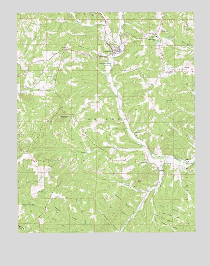
Gainesville, MO USGS Topographic Map
Click on map above to begin viewing in our Map Viewer.

This topographic map contains these locations and features:
Feature Name Type Latitude Longitude GNIS ID View Map
Assembly of God ChurchChurchN36.5395°W92.4085°713452View Map
Bald DaveSummitN36.5290°W92.4160°713584View Map
Becky Cobb CreekStreamN36.6067°W92.4271°713848View Map
Cane Patch RidgeRidgeN36.5087°W92.3902°715353View Map
Center Point ChurchChurchN36.5826°W92.4927°735553View Map
City of GainesvilleCivilN36.6063°W92.4246°2394838View Map
Coon Den HollowValleyN36.5103°W92.4040°716264View Map
Fletcher HollowValleyN36.5062°W92.4546°718021View Map
Full Gospel ChurchChurchN36.6053°W92.4641°718285View Map
GainesvillePopulated PlaceN36.6031°W92.4282°718308View Map
Gainesville CemeteryCemeteryN36.5948°W92.4332°718309View Map
Gainesville Fire DepartmentBuildingN36.6042°W92.4285°2621136View Map
Gainesville High SchoolSchoolN36.6112°W92.4015°718310View Map
Gainesville Memorial AirportAirportN36.6125°W92.4011°758687View Map
Gainesville Police DepartmentBuildingN36.6037°W92.4287°2752366View Map
Gainesville Post OfficePost OfficeN36.6022°W92.4316°2783217View Map
Harrison CreekStreamN36.5956°W92.4343°719157View Map
Hogard CreekStreamN36.6178°W92.4368°719688View Map
John CreekStreamN36.5265°W92.4024°720337View Map
KMAC-FM (Gainesville)TowerN36.5898°W92.3965°759112View Map
Lilly Ridge SchoolSchoolN36.5920°W92.3932°734276View Map
Lily RidgeRidgeN36.5928°W92.3852°721062View Map
Lily Ridge ChurchChurchN36.5906°W92.3929°721063View Map
Little CreekStreamN36.5486°W92.4106°721196View Map
Little Pine CreekStreamN36.5003°W92.4499°721293View Map
Luther CreekStreamN36.5244°W92.4036°51518View Map
MammothPopulated PlaceN36.5359°W92.4007°733841View Map
Mammoth CemeteryCemeteryN36.5401°W92.3960°721781View Map
Merrell Lake DamDamN36.6067°W92.4018°764094View Map
Merrill LakeReservoirN36.6067°W92.4018°764095View Map
Middle RidgeRidgeN36.5034°W92.3938°722287View Map
Never Fail School (historical)SchoolN36.5595°W92.4452°733840View Map
New Hope CemeteryCemeteryN36.5237°W92.4821°723227View Map
New Hope School (historical)SchoolN36.5045°W92.4843°733839View Map
Orchard HollowValleyN36.5123°W92.4171°723842View Map
Ozark County Sheriff's OfficeBuildingN36.6000°W92.4490°2752451View Map
Persimmon HollowValleyN36.5009°W92.4288°724246View Map
Pontiac / Price Place Volunteer Fire Department Station 2BuildingN36.5469°W92.4980°2621056View Map
Possum Walk CreekStreamN36.5425°W92.3954°53715View Map
Rail HollowValleyN36.5087°W92.4218°725070View Map
Saint William ChurchChurchN36.5998°W92.4432°725913View Map
Sanders CemeteryCemeteryN36.5570°W92.4182°726027View Map
Sims CemeteryCemeteryN36.6234°W92.4452°726478View Map
Spring HollowValleyN36.5167°W92.4046°726931View Map
Timbered KnobSummitN36.5659°W92.4704°727669View Map
Township of BridgesCivilN36.5803°W92.4134°767126View Map
Township of West BridgesCivilN36.5945°W92.4982°2397894View Map

Note: Coordinates in the location and feature list above are referenced to NAD83 datum.


Copyright (C) 2008-2025 Ryan Niemi / Sunset Dynamics ... All Rights Reserved