TopoQuest Logo
Do you find TopoQuest useful?
Help keep TopoQuest running and adding new maps/features by donating!
Bitcoin:  19c7KJd3qBynnjoSw5npx9KScwjBe4ifkT
Litecoin:  LXs6TkuXGGXo1vDsWCkWVdjQX94eUKd6ui
Home View Maps Find Maps Find Places Resources & Links


Mountain City, Texas Topographic Map

USGS Map Title: Mountain City, TX
USGS Map MRC: 30097A8
DRG (GeoTIFF) Download: o30097a8.tif


Neighboring USGS Topographic Map Quads:


  Dripping Springs, TX  
30098B1
 

  Signal Hill, TX  
30097B8
 

  Oak Hill, TX  
30097B7
 

  Driftwood, TX  
30098A1
 

  Mountain City, TX  
30097A8
 

  Buda, TX  
30097A7
 

  Wimberley, TX  
29098H1
 

  San Marcos North, TX  
29097H8
 

  Uhland, TX  
29097H7


Map MRC Location:

N31°
W98°
N31°
W97°
H8 H7 H6 H5 H4 H3 H2 H1
G8 G7 G6 G5 G4 G3 G2 G1
F8 F7 F6 F5 F4 F3 F2 F1
E8 E7 E6 E5 E4 E3 E2 E1
D8 D7 D6 D5 D4 D3 D2 D1
C8 C7 C6 C5 C4 C3 C2 C1
B8 B7 B6 B5 B4 B3 B2 B1
A8 A7 A6 A5 A4 A3 A2 A1
N30°
W98°
N30°
W97°

Mountain City, TX USGS 1:24K Topographic Map Preview:
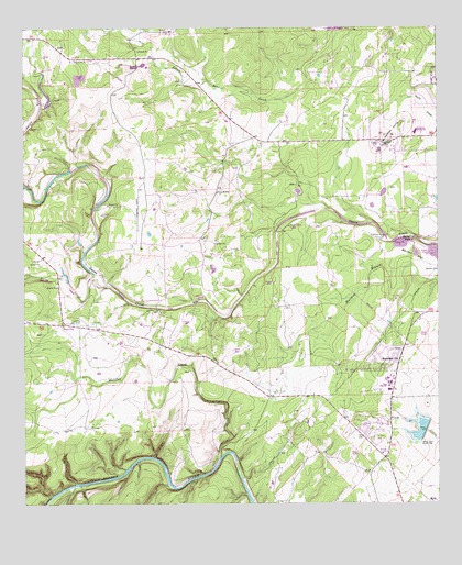
Mountain City, TX USGS Topographic Map
Click on map above to begin viewing in our Map Viewer.

This topographic map contains these locations and features:
Feature Name Type Latitude Longitude GNIS ID View Map
Barber FallsFallsN30.0698°W97.8828°1330027View Map
Barton HillSummitN30.0658°W97.8822°1330110View Map
Bob Shelton StadiumParkN30.0255°W97.8922°2027993View Map
Brown Ranch DamDamN30.1052°W97.9936°1857363View Map
Carpenter HillsSummitN30.0941°W97.8911°1332183View Map
City of Mountain CityCivilN30.0392°W97.8915°2411184View Map
Dahlstrom Intermediate SchoolSchoolN30.1210°W97.9678°2006619View Map
Farris RanchLocaleN30.0947°W97.9364°1335721View Map
Flatrock FordPopulated PlaceN30.0705°W97.8908°1378301View Map
Gregg RanchLocaleN30.0088°W97.8958°1337007View Map
Halifax CreekStreamN30.0130°W97.9403°1337242View Map
Halifax RanchLocaleN30.0113°W97.9431°1337243View Map
Hays Alternative Impact CenterSchoolN30.1208°W97.9578°2006627View Map
Hays CityPopulated PlaceN30.0474°W97.9883°1384863View Map
Hays County Constable's Office Precinct 2BuildingN30.0241°W97.8916°2739376View Map
Hays County Sheriff's Office Driftwood SubstationBuildingN30.0480°W97.9890°2739204View Map
Hoskins RanchLocaleN30.0658°W97.9428°1338144View Map
KATG-FM (Luling)TowerN30.0452°W97.8808°1385927View Map
KEYI-FM (San Marcos)TowerN30.0452°W97.8808°1386006View Map
Kuykendall RanchLocaleN30.0480°W97.9783°1339255View Map
Kyle-Buda DivisionCivilN30.0479°W97.8860°1938894View Map
Lutranger LakeReservoirN30.0302°W97.9370°1865413View Map
Lutranger Lake DamDamN30.0302°W97.9370°1865412View Map
Michaelis RanchLocaleN30.0297°W97.9217°1341464View Map
Mountain CityPopulated PlaceN30.0372°W97.8869°1378711View Map
Mountain City City HallBuildingN30.0377°W97.8893°2753852View Map
Onion Creek LodgeLocaleN30.0747°W97.9147°1343284View Map
Phillips RanchLocaleN30.0191°W97.9906°1343948View Map
Rattlesnake LakeReservoirN30.1049°W97.9935°1857364View Map
Ruby RanchLocaleN30.0888°W97.9195°1345734View Map
Rutherford RanchLocaleN30.0683°W97.9664°1345783View Map
Rutherford Ranch AirportAirportN30.0724°W97.9656°1386313View Map
Soil Conservation Service Site 1 DamDamN30.0202°W97.8786°1857361View Map
Soil Conservation Service Site 1 ReservoirReservoirN30.0197°W97.8805°1857362View Map
Yorks CreekStreamN30.0605°W97.9783°1350692View Map

Note: Coordinates in the location and feature list above are referenced to NAD83 datum.


Copyright (C) 2008-2025 Ryan Niemi / Sunset Dynamics ... All Rights Reserved