TopoQuest Logo
Do you find TopoQuest useful?
Help keep TopoQuest running and adding new maps/features by donating!
Bitcoin:  19c7KJd3qBynnjoSw5npx9KScwjBe4ifkT
Litecoin:  LXs6TkuXGGXo1vDsWCkWVdjQX94eUKd6ui
Home View Maps Find Maps Find Places Resources & Links


Union, Alabama Topographic Map

USGS Map Title: Union, AL
USGS Map MRC: 32087H8
DRG (GeoTIFF) Download: o32087h8.tif


Neighboring USGS Topographic Map Quads:


  Pleasant Ridge, AL  
33088A1
 

  Mantua, AL  
33087A8
 

  Ralph, AL  
33087A7
 

  West Greene, AL  
32088H1
 

  Union, AL  
32087H8
 

  Knoxville, AL  
32087H7
 

  Boligee, AL  
32088G1
 

  Eutaw, AL  
32087G8
 

  Warrior Dam, AL  
32087G7


Map MRC Location:

N33°
W88°
N33°
W87°
H8 H7 H6 H5 H4 H3 H2 H1
G8 G7 G6 G5 G4 G3 G2 G1
F8 F7 F6 F5 F4 F3 F2 F1
E8 E7 E6 E5 E4 E3 E2 E1
D8 D7 D6 D5 D4 D3 D2 D1
C8 C7 C6 C5 C4 C3 C2 C1
B8 B7 B6 B5 B4 B3 B2 B1
A8 A7 A6 A5 A4 A3 A2 A1
N32°
W88°
N32°
W87°

Union, AL USGS 1:24K Topographic Map Preview:
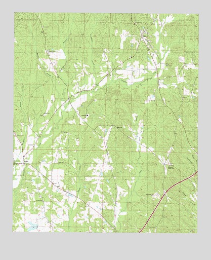
Union, AL USGS Topographic Map
Click on map above to begin viewing in our Map Viewer.

This topographic map contains these locations and features:
Feature Name Type Latitude Longitude GNIS ID View Map
Allen Hall Plantation (historical)LocaleN32.8940°W87.8895°132445View Map
Beech Grove School (historical)SchoolN32.9532°W87.9609°132456View Map
Big SpringSpringN32.8826°W87.9264°132466View Map
Birdon Hill ChurchChurchN32.9946°W87.9197°158787View Map
Burton Hill School (historical)SchoolN32.9954°W87.9181°132490View Map
ClintonPopulated PlaceN32.9137°W87.9925°116272View Map
Clinton Baptist ChurchChurchN32.9140°W87.9950°158113View Map
Clinton Church (historical)ChurchN32.9146°W87.9922°132504View Map
Clinton Post OfficePost OfficeN32.9148°W87.9930°169108View Map
Cobb Plantation (historical)LocaleN32.9621°W87.9117°132506View Map
De Soto Indian Fortification (historical)LocaleN32.8826°W87.9264°132528View Map
Double O Hunting ClubLocaleN32.9901°W87.9797°132525View Map
Drew BranchStreamN32.9226°W87.9156°117470View Map
Duck PondLakeN32.9045°W87.9863°132527View Map
Eatman Elementary SchoolSchoolN32.9418°W87.9509°165410View Map
Ebenezer CemeteryCemeteryN32.9157°W87.9997°117813View Map
Ebenezer Presbyterian Church (historical)ChurchN32.9148°W87.9992°158970View Map
Eutaw DivisionCivilN32.8969°W87.8766°161613View Map
Fortsons Mills (historical)LocaleN32.9510°W87.9625°132553View Map
Greenon CemeteryCemeteryN32.8849°W87.8979°158971View Map
Harkness BranchStreamN32.8976°W87.9986°119737View Map
Harkness School (historical)SchoolN32.8937°W87.9803°132569View Map
Harris CemeteryCemeteryN32.9357°W87.9892°119793View Map
Hick CemeteryCemeteryN32.9153°W87.9350°158843View Map
Hogley Wood CemeteryCemeteryN32.8927°W87.9796°169124View Map
Hopewell ChurchChurchN32.9879°W87.9042°132585View Map
Indian BranchStreamN32.9554°W87.9475°120629View Map
Ingham School (historical)SchoolN32.9393°W87.9386°132590View Map
Johnson Hill CemeteryCemeteryN32.9713°W87.8957°132597View Map
Johnson Hill Methodist ChurchChurchN32.9710°W87.8972°157995View Map
Johnson Hill School (historical)SchoolN32.9710°W87.8970°132598View Map
McLean Lake Number 1ReservoirN32.8777°W87.9861°131073View Map
McMillan PondLakeN32.8839°W87.9796°132636View Map
Mount Carmel Baptist ChurchChurchN32.9921°W87.9811°158017View Map
Murphy BranchStreamN32.9507°W87.9684°123599View Map
Piney Grove Baptist ChurchChurchN32.8785°W87.9031°158054View Map
Pleasant Hill CemeteryCemeteryN32.9785°W87.9770°169123View Map
Pleasant Hill Presbyterian ChurchChurchN32.9782°W87.9775°158904View Map
Pyle CemeteryCemeteryN32.9322°W87.9662°125375View Map
Rehoboth Baptist ChurchChurchN32.9248°W87.9859°158064View Map
Rehoboth Church (historical)ChurchN32.9293°W87.9661°132690View Map
Rehoboth Church Number 2ChurchN32.9301°W87.9978°153133View Map
Roden CemeteryCemeteryN32.9148°W87.9695°153207View Map
Saint Matthews ChurchChurchN32.8929°W87.9797°158918View Map
Sam AcreLocaleN32.9451°W87.9834°143763View Map
Smith School (historical)SchoolN32.8779°W87.9031°132706View Map
Smiths CemeteryCemeteryN32.8969°W87.9061°153481View Map
South Union (historical)LocaleN32.9751°W87.9070°132710View Map
Spencer BranchStreamN32.9462°W87.9656°127180View Map
Spencer CemeteryCemeteryN32.9426°W87.9803°127182View Map
Springfield Lookout TowerTowerN32.9129°W87.8950°164423View Map
Sunflower Church (historical)ChurchN32.9912°W87.9528°132720View Map
Sunflower School (historical)SchoolN32.9907°W87.9520°132721View Map
Town of UnionCivilN32.9938°W87.9072°2406776View Map
UnionPopulated PlaceN32.9882°W87.9150°128262View Map
Union CemeteryCemeteryN32.9945°W87.9176°169121View Map
Union Christian ChurchChurchN32.9526°W87.8858°153766View Map
Union Christian Church CemeteryCemeteryN32.9520°W87.8854°169122View Map
Union SchoolSchoolN32.9798°W87.9183°132734View Map
W P McLean Dam Number 1DamN32.8785°W87.9834°131074View Map
Walker CemeteryCemeteryN32.9348°W87.9303°128508View Map

Note: Coordinates in the location and feature list above are referenced to NAD83 datum.


Copyright (C) 2008-2024 Ryan Niemi / Sunset Dynamics ... All Rights Reserved