TopoQuest Logo
Do you find TopoQuest useful?
Help keep TopoQuest running and adding new maps/features by donating!
Bitcoin:  19c7KJd3qBynnjoSw5npx9KScwjBe4ifkT
Litecoin:  LXs6TkuXGGXo1vDsWCkWVdjQX94eUKd6ui
Home View Maps Find Maps Find Places Resources & Links


Boligee, Alabama Topographic Map

USGS Map Title: Boligee, AL
USGS Map MRC: 32088G1
DRG (GeoTIFF) Download: o32088g1.tif


Neighboring USGS Topographic Map Quads:


  Warsaw, AL  
32088H2
 

  West Greene, AL  
32088H1
 

  Union, AL  
32087H8
 

  Gainesville, AL  
32088G2
 

  Boligee, AL  
32088G1
 

  Eutaw, AL  
32087G8
 

  Epes West, AL  
32088F2
 

  Epes East, AL  
32088F1
 

  Forkland, AL  
32087F8


Map MRC Location:

N33°
W89°
N33°
W88°
H8 H7 H6 H5 H4 H3 H2 H1
G8 G7 G6 G5 G4 G3 G2 G1
F8 F7 F6 F5 F4 F3 F2 F1
E8 E7 E6 E5 E4 E3 E2 E1
D8 D7 D6 D5 D4 D3 D2 D1
C8 C7 C6 C5 C4 C3 C2 C1
B8 B7 B6 B5 B4 B3 B2 B1
A8 A7 A6 A5 A4 A3 A2 A1
N32°
W89°
N32°
W88°

Boligee, AL USGS 1:24K Topographic Map Preview:
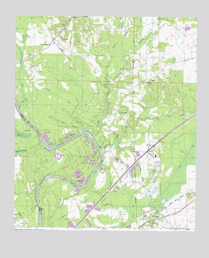
Boligee, AL USGS Topographic Map
Click on map above to begin viewing in our Map Viewer.

This topographic map contains these locations and features:
Feature Name Type Latitude Longitude GNIS ID View Map
Bar BranchStreamN32.8076°W88.0789°113459View Map
Blind ShoalsBarN32.7901°W88.0647°134092View Map
Blue LakeLakeN32.7926°W88.0942°134093View Map
Boatright CemeteryCemeteryN32.7829°W88.0256°158789View Map
BoligeePopulated PlaceN32.7560°W88.0289°114691View Map
Boligee CanalCanalN32.7679°W88.0256°114692View Map
Boligee CemeteryCemeteryN32.7552°W88.0301°158628View Map
Boligee Creek SwampSwampN32.7839°W88.0114°132474View Map
Boligee DivisionCivilN32.7630°W88.0277°165788View Map
Boligee High SchoolSchoolN32.7512°W88.0306°154918View Map
Boligee Post OfficePost OfficeN32.7572°W88.0294°169022View Map
Boligee Volunteer Fire DepartmentBuildingN32.7555°W88.0256°2691366View Map
Browns Artesian Mill (historical)LocaleN32.8224°W88.0311°132483View Map
Brush CreekStreamN32.7949°W88.0653°115044View Map
Brush Creek BarBarN32.7976°W88.0664°132485View Map
Clays BarBarN32.7737°W88.0817°134111View Map
Clays BluffCliffN32.7757°W88.0745°132501View Map
Clays Landing (historical)LocaleN32.7726°W88.0789°132502View Map
Cobbs BranchStreamN32.8351°W88.0622°116329View Map
Collins CemeteryCemeteryN32.8601°W88.0925°116440View Map
Cooks BranchStreamN32.8096°W88.0781°116538View Map
Cooks CemeteryCemeteryN32.8215°W88.0750°116540View Map
Crawford CemeteryCemeteryN32.8426°W88.0449°158403View Map
Crawford ForkPopulated PlaceN32.8179°W88.0542°116829View Map
Croft Place (historical)LocaleN32.8307°W88.0703°132519View Map
Crossroads of America Industrial ParkLocaleN32.7849°W88.0492°132520View Map
Cubbs Creek ShoalsBarN32.8168°W88.1222°134122View Map
Dry CreekStreamN32.8182°W88.0078°117537View Map
Dry CreekStreamN32.8587°W88.0420°117568View Map
Exit 32CrossingN32.7965°W88.0311°155709View Map
Friends BarBarN32.7776°W88.0897°132554View Map
Friends Landing (historical)LocaleN32.7787°W88.0920°132555View Map
Gladys LandingLocaleN32.7846°W88.0664°156407View Map
Gotes CemeteryCemeteryN32.8407°W88.1081°158404View Map
Hill CemeteryCemeteryN32.8507°W88.1153°132579View Map
Horseshoe Lake (historical)LakeN32.7897°W88.0949°158128View Map
Howards BarBarN32.8087°W88.1125°132587View Map
Howards Lower BarBarN32.8068°W88.1109°134164View Map
Jack Toms ShoalsBarN32.7562°W88.1067°132591View Map
King LakeLakeN32.8646°W88.0331°132603View Map
Kingdom Baptist ChurchChurchN32.8351°W88.0320°157996View Map
Kirksey CemeteryCemeteryN32.7574°W88.0505°121259View Map
LizzievillePopulated PlaceN32.7876°W88.0289°121933View Map
Macedonia Baptist ChurchChurchN32.8362°W88.0311°158006View Map
Macedonia CemeteryCemeteryN32.8363°W88.0312°158636View Map
Meeting House BranchStreamN32.7771°W88.0736°132637View Map
Morgan CemeteryCemeteryN32.8726°W88.0856°123039View Map
Morning Star CemeteryCemeteryN32.8347°W88.0676°158637View Map
Morning Star Church (historical)ChurchN32.8249°W88.0709°132649View Map
Morning Star Missionary Baptist ChurchChurchN32.8349°W88.0675°158016View Map
Mount HebronPopulated PlaceN32.8740°W88.0797°156744View Map
Mount Hebron CemeteryCemeteryN32.8585°W88.0828°158639View Map
Mount Hebron ChurchChurchN32.8735°W88.0800°132653View Map
Mount Hebron School (historical)SchoolN32.8746°W88.0814°155317View Map
Mount Olive Baptist ChurchChurchN32.8346°W88.0442°158022View Map
Mount Zion Baptist ChurchChurchN32.8679°W88.0909°158036View Map
Mount Zion CemeteryCemeteryN32.8673°W88.0911°158642View Map
New Mount HebronPopulated PlaceN32.8571°W88.1011°156787View Map
Oak Hill Plantation (historical)LocaleN32.8632°W88.1181°132665View Map
Old Factory (historical)LocaleN32.8571°W88.0370°132669View Map
Paramount High School (historical)SchoolN32.7921°W88.0278°132673View Map
Rogers CreekStreamN32.8718°W88.0267°125905View Map
Saint Jesus ChurchChurchN32.7687°W88.0303°132692View Map
Saint Marks ChurchChurchN32.7524°W88.0292°159013View Map
Saint Paul CemeteryCemeteryN32.7834°W88.0291°158658View Map
Saint Pauls Baptist ChurchChurchN32.7843°W88.0289°158074View Map
Sebastopol Plantation (historical)LocaleN32.7612°W88.0078°1729890View Map
Solomon HillSummitN32.8557°W88.0264°132709View Map
Speed Quarters CemeteryCemeteryN32.8623°W88.0483°158418View Map
Swilleys BendBendN32.7893°W88.0761°153632View Map
Swilleys Landing (historical)LocaleN32.7746°W88.1081°134273View Map
Toms BarBarN32.7779°W88.1050°134275View Map
Town of BoligeeCivilN32.7700°W88.0265°2405297View Map
Trice LakeReservoirN32.7695°W88.0332°128070View Map
Trussel ShoalsBarN32.8040°W88.0800°132729View Map
Trussells CreekStreamN32.8049°W88.0792°155279View Map
Trussells Ferry (historical)CrossingN32.8051°W88.0722°132726View Map
Trussells Mills (historical)LocaleN32.8687°W88.0275°132727View Map
Trussels LandingLocaleN32.8065°W88.0747°132728View Map
Tubbs CreekStreamN32.7737°W88.1086°134278View Map
Tubbs CreekStreamN32.8190°W88.1222°155280View Map
Turkey Roost (historical)LocaleN32.8154°W88.1167°132731View Map
Union Church (historical)ChurchN32.8418°W88.0447°132733View Map

Note: Coordinates in the location and feature list above are referenced to NAD83 datum.


Copyright (C) 2008-2024 Ryan Niemi / Sunset Dynamics ... All Rights Reserved