TopoQuest Logo
Do you find TopoQuest useful?
Help keep TopoQuest running and adding new maps/features by donating!
Bitcoin:  19c7KJd3qBynnjoSw5npx9KScwjBe4ifkT
Litecoin:  LXs6TkuXGGXo1vDsWCkWVdjQX94eUKd6ui
Home View Maps Find Maps Find Places Resources & Links


Mantua, Alabama Topographic Map

USGS Map Title: Mantua, AL
USGS Map MRC: 33087A8
DRG (GeoTIFF) Download: o33087a8.tif


Neighboring USGS Topographic Map Quads:


  Cunningham, AL  
33088B1
 

  Kirk, AL  
33087B8
 

  Romulus, AL  
33087B7
 

  Pleasant Ridge, AL  
33088A1
 

  Mantua, AL  
33087A8
 

  Ralph, AL  
33087A7
 

  West Greene, AL  
32088H1
 

  Union, AL  
32087H8
 

  Knoxville, AL  
32087H7


Map MRC Location:

N34°
W88°
N34°
W87°
H8 H7 H6 H5 H4 H3 H2 H1
G8 G7 G6 G5 G4 G3 G2 G1
F8 F7 F6 F5 F4 F3 F2 F1
E8 E7 E6 E5 E4 E3 E2 E1
D8 D7 D6 D5 D4 D3 D2 D1
C8 C7 C6 C5 C4 C3 C2 C1
B8 B7 B6 B5 B4 B3 B2 B1
A8 A7 A6 A5 A4 A3 A2 A1
N33°
W88°
N33°
W87°

Mantua, AL USGS 1:24K Topographic Map Preview:
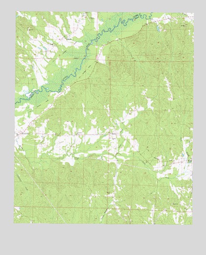
Mantua, AL USGS Topographic Map
Click on map above to begin viewing in our Map Viewer.

This topographic map contains these locations and features:
Feature Name Type Latitude Longitude GNIS ID View Map
Baileys Bridge (historical)BridgeN33.1215°W87.9061°132448View Map
BenevolaPopulated PlaceN33.1093°W87.9650°113912View Map
Bethesda Church Yard CemeteryCemeteryN33.1059°W87.9733°135467View Map
Bethesda Presbyterian ChurchChurchN33.1054°W87.9728°114105View Map
Box CreekStreamN33.1221°W87.9164°114783View Map
Cottons Bridge (historical)BridgeN33.1015°W87.9511°135503View Map
Eutaw African Methodist Episcopal ChurchChurchN33.0632°W87.9845°150856View Map
Forest Baptist ChurchChurchN33.1243°W87.9511°118487View Map
Forest Church CemeteryCemeteryN33.1234°W87.9514°135522View Map
Hebron CemeteryCemeteryN33.0185°W87.9322°119921View Map
Hollingsworth School (historical)SchoolN33.0048°W87.9953°132583View Map
Hopewell Baptist ChurchChurchN33.0123°W87.8892°157988View Map
Hopewell CemeteryCemeteryN33.0129°W87.8883°158634View Map
Laniers Mill (historical)LocaleN33.0823°W87.9661°132608View Map
Little CreekStreamN33.0421°W87.9275°121754View Map
Manatua CemeteryCemeteryN33.0510°W87.9322°132622View Map
MantuaPopulated PlaceN33.0537°W87.9289°156654View Map
Mantua - Lewiston Volunteer Fire DepartmentBuildingN33.0530°W87.9766°2691377View Map
Mantua Post OfficePost OfficeN33.0540°W87.9284°169029View Map
Morrows GrovePopulated PlaceN33.0535°W87.9947°152384View Map
Mount Moriah CemeteryCemeteryN33.1148°W87.8908°158610View Map
Mount Moriah ChurchChurchN33.1140°W87.9909°123258View Map
Mount Sinai Methodist ChurchChurchN33.0451°W87.9292°158119View Map
Mount Zion ChurchChurchN33.0504°W87.9314°152528View Map
Rosenwald School (historical)SchoolN33.0396°W87.9106°132691View Map
Saint Pauls ChurchChurchN33.1204°W87.8958°132698View Map
Sixteenth Section CemeteryCemeteryN33.0587°W87.9856°158417View Map
Smith BranchStreamN33.0312°W87.8803°127000View Map
SnoddyPopulated PlaceN33.0387°W87.8756°157083View Map
White Oak Grove School (historical)SchoolN33.0532°W87.9570°132744View Map
White Oak Presbyterian ChurchChurchN33.0532°W87.9567°157930View Map
Zion Hill Baptist ChurchChurchN33.1171°W87.8811°158966View Map
Zion Hill CemeteryCemeteryN33.1182°W87.8814°158662View Map

Note: Coordinates in the location and feature list above are referenced to NAD83 datum.


Copyright (C) 2008-2024 Ryan Niemi / Sunset Dynamics ... All Rights Reserved