TopoQuest Logo
Do you find TopoQuest useful?
Help keep TopoQuest running and adding new maps/features by donating!
Bitcoin:  19c7KJd3qBynnjoSw5npx9KScwjBe4ifkT
Litecoin:  LXs6TkuXGGXo1vDsWCkWVdjQX94eUKd6ui
Home View Maps Find Maps Find Places Resources & Links


Union, Oregon Topographic Map

USGS Map Title: Union, OR
USGS Map MRC: 45117B7
DRG (GeoTIFF) Download: o45117b7.tif


Neighboring USGS Topographic Map Quads:


  Conley, OR  
45117C8
 

  Cove, OR  
45117C7
 

  Mount Fanny, OR  
45117C6
 

  Craig Mountain, OR  
45117B8
 

  Union, OR  
45117B7
 

  Little Catherine Creek, OR  
45117B6
 

  North Powder, OR  
45117A8
 

  Telocaset, OR  
45117A7
 

  Medical Springs, OR  
45117A6


Map MRC Location:

N46°
W118°
N46°
W117°
H8 H7 H6 H5 H4 H3 H2 H1
G8 G7 G6 G5 G4 G3 G2 G1
F8 F7 F6 F5 F4 F3 F2 F1
E8 E7 E6 E5 E4 E3 E2 E1
D8 D7 D6 D5 D4 D3 D2 D1
C8 C7 C6 C5 C4 C3 C2 C1
B8 B7 B6 B5 B4 B3 B2 B1
A8 A7 A6 A5 A4 A3 A2 A1
N45°
W118°
N45°
W117°

Union, OR USGS 1:24K Topographic Map Preview:
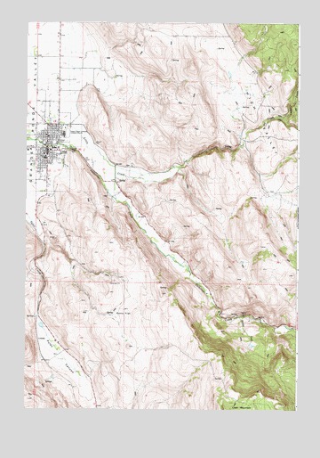
Union, OR USGS Topographic Map
Click on map above to begin viewing in our Map Viewer.

This topographic map contains these locations and features:
Feature Name Type Latitude Longitude GNIS ID View Map
Brinker CreekStreamN45.1554°W117.7780°1118084View Map
Catherine Creek Highline CanalCanalN45.2499°W117.8516°1130901View Map
City of UnionCivilN45.2089°W117.8679°2412129View Map
CrooksLocaleN45.1476°W117.8691°1158188View Map
Draper CreekStreamN45.1915°W117.7760°1129463View Map
Dry GulchValleyN45.2012°W117.7691°1129662View Map
Eastern Oregon Livestock Exposition GroundsParkN45.2140°W117.8563°1120361View Map
Eastern Oregon Livestock ShowLocaleN45.2135°W117.8580°2700337View Map
Elmer DitchCanalN45.2215°W117.7622°1158682View Map
Kelly Springs CreekStreamN45.1790°W117.8663°1129461View Map
Marion (historical)LocaleN45.2207°W117.8608°1129462View Map
Park (historical)LocaleN45.1665°W117.7969°1129464View Map
Potters CreekStreamN45.2193°W117.7583°1125621View Map
Prescott DitchCanalN45.1999°W117.8608°1129460View Map
Pursel SpringSpringN45.1565°W117.8552°1158574View Map
Pyles CanyonValleyN45.1796°W117.8672°1125714View Map
Ramo FlatFlatN45.1549°W117.8299°1125794View Map
UnionPopulated PlaceN45.2085°W117.8652°1128409View Map
Union Carnegie Public LibraryBuildingN45.2099°W117.8657°2700356View Map
Union CemeteryCemeteryN45.2046°W117.8585°1116573View Map
Union City Fire DepartmentBuildingN45.2077°W117.8606°2576780View Map
Union City HallBuildingN45.2074°W117.8658°2700357View Map
Union City ParkParkN45.2107°W117.8688°2091236View Map
Union County MuseumBuildingN45.2076°W117.8652°2700361View Map
Union Elementary SchoolSchoolN45.2067°W117.8664°2490918View Map
Union High SchoolSchoolN45.2061°W117.8661°2490937View Map
Union Post OfficePost OfficeN45.2079°W117.8658°1166084View Map
Union Public WorksBuildingN45.2198°W117.8674°2700333View Map
Union Rural Fire Protection DistrictBuildingN45.2081°W117.8606°2576461View Map
Union Wastewater Treatment PlantLocaleN45.2101°W117.8656°2697040View Map
Wigglesworth SpringSpringN45.1692°W117.8375°1158681View Map

Note: Coordinates in the location and feature list above are referenced to NAD83 datum.


Copyright (C) 2008-2025 Ryan Niemi / Sunset Dynamics ... All Rights Reserved