TopoQuest Logo
Do you find TopoQuest useful?
Help keep TopoQuest running and adding new maps/features by donating!
Bitcoin:  19c7KJd3qBynnjoSw5npx9KScwjBe4ifkT
Litecoin:  LXs6TkuXGGXo1vDsWCkWVdjQX94eUKd6ui
Home View Maps Find Maps Find Places Resources & Links


North Powder, Oregon Topographic Map

USGS Map Title: North Powder, OR
USGS Map MRC: 45117A8
DRG (GeoTIFF) Download: o45117a8.tif


Neighboring USGS Topographic Map Quads:


  Glass Hill, OR  
45118B1
 

  Craig Mountain, OR  
45117B8
 

  Union, OR  
45117B7
 

  Tucker Flat, OR  
45118A1
 

  North Powder, OR  
45117A8
 

  Telocaset, OR  
45117A7
 

  Rock Creek, OR  
44118H1
 

  Haines, OR  
44117H8
 

  Magpie Peak, OR  
44117H7


Map MRC Location:

N46°
W118°
N46°
W117°
H8 H7 H6 H5 H4 H3 H2 H1
G8 G7 G6 G5 G4 G3 G2 G1
F8 F7 F6 F5 F4 F3 F2 F1
E8 E7 E6 E5 E4 E3 E2 E1
D8 D7 D6 D5 D4 D3 D2 D1
C8 C7 C6 C5 C4 C3 C2 C1
B8 B7 B6 B5 B4 B3 B2 B1
A8 A7 A6 A5 A4 A3 A2 A1
N45°
W118°
N45°
W117°

North Powder, OR USGS 1:24K Topographic Map Preview:
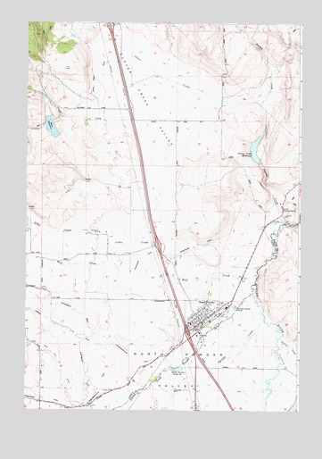
North Powder, OR USGS Topographic Map
Click on map above to begin viewing in our Map Viewer.

This topographic map contains these locations and features:
Feature Name Type Latitude Longitude GNIS ID View Map
City of North PowderCivilN45.0300°W117.9204°2411277View Map
Clover CreekStreamN45.0988°W117.8941°1119035View Map
Clover Creek ValleyValleyN45.0521°W117.9322°1119037View Map
Dorion Historical MarkerLocaleN45.0651°W117.8835°1163700View Map
Gentry CreekStreamN45.0235°W117.8838°1142609View Map
Gussie CreekStreamN45.1004°W117.9733°1153739View Map
Hot CreekStreamN45.0285°W117.8913°1122054View Map
Jimmy CreekStreamN45.0604°W117.8822°1122431View Map
Little CreekStreamN45.0488°W117.8902°1158324View Map
Lun (historical)LocaleN45.0596°W117.8916°1158691View Map
Moody DitchCanalN45.0457°W117.9774°1116657View Map
North PowderPopulated PlaceN45.0285°W117.9199°1124835View Map
North Powder City HallBuildingN45.0292°W117.9205°2700351View Map
North Powder Pond Number OneLakeN45.0132°W117.9305°1124836View Map
North Powder Post OfficePost OfficeN45.0284°W117.9201°1165715View Map
North Powder Public LibraryBuildingN45.0292°W117.9205°2700352View Map
North Powder RiverStreamN45.0385°W117.8955°1147052View Map
North Powder Rural Fire Protection DistrictBuildingN45.0297°W117.9208°2576490View Map
North Powder Sewer Treatment PlantLocaleN45.0331°W117.9048°2697073View Map
North Powder ValleyBasinN45.0079°W117.8994°1147053View Map
Parker SpringsSpringN45.0485°W117.9316°1130907View Map
Peach CreekStreamN45.0935°W117.9538°1147521View Map
Pearson DitchCanalN45.0032°W117.9649°1131532View Map
Powder Valley SchoolSchoolN45.0283°W117.9259°2490899View Map
Pratt Ranch Airstrip (historical)AirportN45.1054°W117.9697°1638087View Map
Shaw Brant DitchCanalN45.0757°W117.9752°1149295View Map
Shaw DamDamN45.0947°W117.9905°1133674View Map
Shaw DitchCanalN45.0143°W117.9730°1149298View Map
Shaw ReservoirReservoirN45.0910°W117.9891°1126806View Map
Sixteen Mile SpringSpringN45.1204°W117.9802°1130984View Map
Stephens SpringSpringN45.1245°W117.9878°1130983View Map
Sunnyslope DitchCanalN45.0549°W117.9238°1127736View Map
Warm Springs CreekStreamN45.0288°W117.8913°1158950View Map
Wolf CreekStreamN45.0438°W117.8944°1152583View Map

Note: Coordinates in the location and feature list above are referenced to NAD83 datum.


Copyright (C) 2008-2024 Ryan Niemi / Sunset Dynamics ... All Rights Reserved