TopoQuest Logo
Do you find TopoQuest useful?
Help keep TopoQuest running and adding new maps/features by donating!
Bitcoin:  19c7KJd3qBynnjoSw5npx9KScwjBe4ifkT
Litecoin:  LXs6TkuXGGXo1vDsWCkWVdjQX94eUKd6ui
Home View Maps Find Maps Find Places Resources & Links


Unionville, Tennessee Topographic Map

USGS Map Title: Unionville, TN
USGS Map MRC: 35086E5
DRG (GeoTIFF) Download: o35086e5.tif


Neighboring USGS Topographic Map Quads:


  Chapel Hill, TN  
35086F6
 

  Rover, TN  
35086F5
 

  Fosterville, TN  
35086F4
 

  Farmington, TN  
35086E6
 

  Unionville, TN  
35086E5
 

  Deason, TN  
35086E4
 

  Belfast, TN  
35086D6
 

  Bedford, TN  
35086D5
 

  Shelbyville, TN  
35086D4


Map MRC Location:

N36°
W87°
N36°
W86°
H8 H7 H6 H5 H4 H3 H2 H1
G8 G7 G6 G5 G4 G3 G2 G1
F8 F7 F6 F5 F4 F3 F2 F1
E8 E7 E6 E5 E4 E3 E2 E1
D8 D7 D6 D5 D4 D3 D2 D1
C8 C7 C6 C5 C4 C3 C2 C1
B8 B7 B6 B5 B4 B3 B2 B1
A8 A7 A6 A5 A4 A3 A2 A1
N35°
W87°
N35°
W86°

Unionville, TN USGS 1:24K Topographic Map Preview:
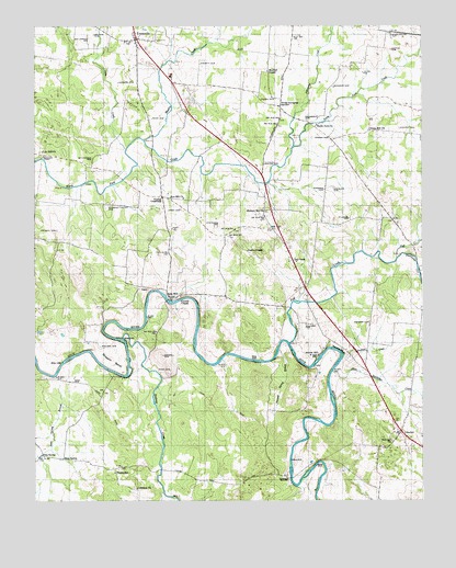
Unionville, TN USGS Topographic Map
Click on map above to begin viewing in our Map Viewer.

This topographic map contains these locations and features:
Feature Name Type Latitude Longitude GNIS ID View Map
Adcock CemeteryCemeteryN35.5981°W86.5069°1275474View Map
Alexander CreekStreamN35.5931°W86.5419°1304794View Map
Allison CemeteryCemeteryN35.6187°W86.5997°1319218View Map
Allison CemeteryCemeteryN35.6201°W86.5794°1319219View Map
Anchor MillPopulated PlaceN35.5381°W86.5333°1314582View Map
Bellview ChurchChurchN35.5156°W86.5097°1276969View Map
Bellview School (historical)SchoolN35.5140°W86.5050°1319238View Map
Bethlehem CemeteryCemeteryN35.5901°W86.6067°1277156View Map
Blackburns Mill (historical)LocaleN35.5892°W86.5817°1319244View Map
Bounds CemeteryCemeteryN35.6228°W86.6058°1278033View Map
Britton FordCrossingN35.5901°W86.6228°1314733View Map
Burton CemeteryCemeteryN35.6190°W86.5100°1279129View Map
Card CemeteryCemeteryN35.5315°W86.6125°1279650View Map
Clark CemeteryCemeteryN35.5903°W86.5889°1319269View Map
Clem CreekStreamN35.5928°W86.5958°1303426View Map
Collier-Jones CemeteryCemeteryN35.5367°W86.5625°1319272View Map
Commissioner District 3CivilN35.6233°W86.5901°2464119View Map
Cook CemeteryCemeteryN35.5342°W86.5817°1281110View Map
Covington CemeteryCemeteryN35.6087°W86.5922°1319277View Map
Crowell CemeteryCemeteryN35.5381°W86.5839°1281748View Map
Crowell CemeteryCemeteryN35.5712°W86.6178°1281749View Map
Crowell CemeteryCemeteryN35.5537°W86.5733°1319282View Map
Crowells Chapel CemeteryCemeteryN35.5540°W86.5772°1319283View Map
Crowells Chapel Lutheran ChurchChurchN35.5540°W86.5781°1306207View Map
Dryland CreekStreamN35.5378°W86.5258°1283035View Map
El Bethel Baptist ChurchChurchN35.5165°W86.5036°1319302View Map
ElbethelPopulated PlaceN35.5184°W86.5067°1283594View Map
Fall CreekPopulated PlaceN35.5634°W86.5419°1315047View Map
Fall CreekStreamN35.5415°W86.5431°1269571View Map
Finney CemeteryCemeteryN35.6059°W86.5475°1284281View Map
Friendship Church (historical)ChurchN35.5298°W86.5733°1319312View Map
Green Hill ChurchChurchN35.5976°W86.5167°1306514View Map
Green Hill School (historical)SchoolN35.5840°W86.5186°1319323View Map
Gregory CemeteryCemeteryN35.5467°W86.5169°1286238View Map
Halls MillPopulated PlaceN35.5534°W86.5819°1315180View Map
Harems Store (historical)LocaleN35.5092°W86.6044°1319328View Map
Harms CemeteryCemeteryN35.5317°W86.6139°1319329View Map
Harrison CemeteryCemeteryN35.5065°W86.5822°1319334View Map
Hickory Hill CemeteryCemeteryN35.5759°W86.5500°1319347View Map
Hickory Hill Methodist ChurchChurchN35.5762°W86.5508°1287603View Map
Hurricane CreekStreamN35.5640°W86.5078°1288808View Map
Jones CemeteryCemeteryN35.5767°W86.5780°1289721View Map
Jones CemeteryCemeteryN35.5601°W86.5353°1319372View Map
Landers CemeteryCemeteryN35.5323°W86.5389°1319379View Map
Landers CemeteryCemeteryN35.6101°W86.5980°1290583View Map
Lebanon ChurchChurchN35.5031°W86.5925°1290908View Map
Lentz CemeteryCemeteryN35.5309°W86.5339°1319382View Map
Lentz CemeteryCemeteryN35.5440°W86.6197°1319383View Map
Lentz ChapelChurchN35.5659°W86.5567°1291023View Map
Lentz-Williams CemeteryCemeteryN35.5295°W86.5753°1319384View Map
Lily Hill ChurchChurchN35.5920°W86.6225°1291284View Map
Little Hurricane CreekStreamN35.5340°W86.5289°1291539View Map
Locke CemeteryCemeteryN35.6015°W86.5803°1319387View Map
Lowell CemeteryCemeteryN35.5345°W86.5908°1319392View Map
Loyd CemeteryCemeteryN35.5701°W86.5183°1319393View Map
Lucas CemeteryCemeteryN35.5292°W86.5992°1319394View Map
Maxwell Chapel United Methodist ChurchChurchN35.6134°W86.5503°1292983View Map
Molder CemeteryCemeteryN35.5090°W86.5819°1319410View Map
Moon CemeteryCemeteryN35.5903°W86.6036°1319412View Map
Moon CemeteryCemeteryN35.6006°W86.5875°1294222View Map
Moore CemeteryCemeteryN35.6020°W86.5811°1319413View Map
Moulder School (historical)SchoolN35.5653°W86.6047°1319411View Map
Mount Lebanon CemeteryCemeteryN35.5034°W86.5928°1319418View Map
North Fork ChurchChurchN35.5992°W86.5342°1295869View Map
Old Crowell Chapel CemeteryCemeteryN35.5534°W86.5800°1319438View Map
Osborn CemeteryCemeteryN35.5562°W86.5405°1319445View Map
Parch Corn CreekStreamN35.5609°W86.5011°1296760View Map
Parsons CemeteryCemeteryN35.5820°W86.5317°1296896View Map
Pisgah CemeteryCemeteryN35.5959°W86.5300°1297713View Map
Pisgah SchoolSchoolN35.5073°W86.5992°1297728View Map
Pleasant Valley CemeteryCemeteryN35.5781°W86.6011°1297933View Map
Pleasant Valley Church (historical)ChurchN35.5742°W86.6069°1319455View Map
Poplins CrossroadsPopulated PlaceN35.5801°W86.5842°1315766View Map
Poplins Crossroads Census Designated PlaceCensusN35.5737°W86.5808°2584590View Map
Potts CemeteryCemeteryN35.5840°W86.5633°1319460View Map
Presgrove CemeteryCemeteryN35.6003°W86.5372°1298472View Map
Ray Corner CemeteryCemeteryN35.6226°W86.6080°1298995View Map
Reeves CemeteryCemeteryN35.5887°W86.5514°1299184View Map
Sanders CemeteryCemeteryN35.6090°W86.5286°1300691View Map
Sawmill Spring BranchStreamN35.5398°W86.5464°1270938View Map
Shearin BendBendN35.5390°W86.6011°1269949View Map
Shearin CemeteryCemeteryN35.5406°W86.6039°1269950View Map
Sims SpringPopulated PlaceN35.5109°W86.6158°1314297View Map
Sims SpringSpringN35.5120°W86.6233°1270358View Map
Sims Spring BranchStreamN35.5303°W86.6169°1270359View Map
Sinking CreekStreamN35.5428°W86.5969°1270383View Map
Stephens CemeteryCemeteryN35.5726°W86.5664°1271330View Map
Story CemeteryCemeteryN35.5031°W86.5939°1319511View Map
Streater CemeteryCemeteryN35.5084°W86.5261°1319503View Map
Streeter CemeteryCemeteryN35.5028°W86.5347°1319504View Map
Tarpley BluffCliffN35.5398°W86.5272°1272133View Map
Terry CemeteryCemeteryN35.5767°W86.5111°1319522View Map
Union Grove Church (historical)ChurchN35.6231°W86.5417°1319536View Map
Union School (historical)SchoolN35.5248°W86.5631°1319539View Map
UnionvillePopulated PlaceN35.6217°W86.5925°1273262View Map
Unionville CemeteryCemeteryN35.6203°W86.5955°1319540View Map
Unionville Census Designated PlaceCensusN35.6118°W86.5739°2584595View Map
Unionville Division (historical)CensusN35.6109°W86.5572°1648600View Map
Unionville First Baptist ChurchChurchN35.6206°W86.5919°1319541View Map
Unionville Methodist ChurchChurchN35.6209°W86.5956°1319542View Map
Unionville Post OfficePost OfficeN35.6057°W86.5768°1651234View Map
Unionville SchoolSchoolN35.6120°W86.5817°1304265View Map
Volunteer Fire Services Station 2 / Unionville Volunteer Fire DepartmentBuildingN35.6065°W86.5775°2654276View Map
Warner BridgeBridgeN35.5059°W86.5422°1304379View Map
Warner CemeteryCemeteryN35.5109°W86.5364°1319550View Map
Weakly CreekStreamN35.5951°W86.5900°1273967View Map
Wheeler CemeteryCemeteryN35.5826°W86.5286°1274283View Map
Wheelhouse CemeteryCemeteryN35.6228°W86.5094°1274296View Map
Whites Chapel School (historical)SchoolN35.6042°W86.5944°1319563View Map
Whitman-Gregory CemeteryCemeteryN35.5612°W86.5172°1319565View Map
Williams CemeteryCemeteryN35.5465°W86.5375°1274643View Map
Williams CemeteryCemeteryN35.5745°W86.5236°1274645View Map
Williams CemeteryCemeteryN35.5753°W86.5536°1319566View Map
Williams CemeteryCemeteryN35.6117°W86.5211°1319567View Map
Wilson CemeteryCemeteryN35.6098°W86.6239°1319569View Map
Winsett CemeteryCemeteryN35.6153°W86.5722°1274886View Map
Wrights Store (historical)LocaleN35.5537°W86.5636°1319575View Map
Zion Hill United Methodist ChurchChurchN35.5798°W86.5772°1304732View Map

Note: Coordinates in the location and feature list above are referenced to NAD83 datum.


Copyright (C) 2008-2024 Ryan Niemi / Sunset Dynamics ... All Rights Reserved