TopoQuest Logo
Do you find TopoQuest useful?
Help keep TopoQuest running and adding new maps/features by donating!
Bitcoin:  19c7KJd3qBynnjoSw5npx9KScwjBe4ifkT
Litecoin:  LXs6TkuXGGXo1vDsWCkWVdjQX94eUKd6ui
Home View Maps Find Maps Find Places Resources & Links


Valdez, Colorado Topographic Map

USGS Map Title: Valdez, CO
USGS Map MRC: 37104A6
DRG (GeoTIFF) Download: o37104a6.tif


Neighboring USGS Topographic Map Quads:


  Weston, CO  
37104B7
 

  Madrid, CO  
37104B6
 

  Trinidad West, CO  
37104B5
 

  Little Pine Canyon, CO  
37104A7
 

  Valdez, CO  
37104A6
 

  Starkville, CO  
37104A5
 

  Caliente Canyon North, NM  
36104H7
 

  McWilliams Canyon, NM  
36104H6
 

  Tin Pan Canyon, NM  
36104H5


Map MRC Location:

N38°
W105°
N38°
W104°
H8 H7 H6 H5 H4 H3 H2 H1
G8 G7 G6 G5 G4 G3 G2 G1
F8 F7 F6 F5 F4 F3 F2 F1
E8 E7 E6 E5 E4 E3 E2 E1
D8 D7 D6 D5 D4 D3 D2 D1
C8 C7 C6 C5 C4 C3 C2 C1
B8 B7 B6 B5 B4 B3 B2 B1
A8 A7 A6 A5 A4 A3 A2 A1
N37°
W105°
N37°
W104°

Valdez, CO USGS 1:24K Topographic Map Preview:
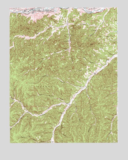
Valdez, CO USGS Topographic Map
Click on map above to begin viewing in our Map Viewer.

This topographic map contains these locations and features:
Feature Name Type Latitude Longitude GNIS ID View Map
Bear CanyonValleyN37.0007°W104.6296°194969View Map
Blind CanyonValleyN37.0148°W104.7476°194816View Map
Burro CanyonValleyN37.1227°W104.6484°194524View Map
Cordova CanyonValleyN37.1220°W104.7492°194818View Map
Cottonwood CanyonValleyN37.0402°W104.7439°194812View Map
Frederick MineMineN37.1003°W104.6805°194821View Map
Gunbarrel CanyonValleyN37.0358°W104.7475°194813View Map
House CanyonValleyN37.0397°W104.6769°194840View Map
Joe Baker CanyonValleyN37.0010°W104.7014°194841View Map
Left Hand Fork Martinez CanyonValleyN37.0292°W104.7294°194814View Map
Leonor CanyonValleyN37.0640°W104.6529°194830View Map
Little Martinez CanyonValleyN37.0369°W104.6865°194836View Map
Madrid Plaza MineMineN37.1242°W104.6458°1735223View Map
Martinez CanyonValleyN37.0359°W104.6820°194835View Map
Middle Fork Widow Woman CanyonValleyN37.0865°W104.6816°194826View Map
Opposite Joe Baker CanyonValleyN37.0020°W104.7024°194834View Map
Parsons Cow CampLocaleN37.0270°W104.6886°194833View Map
Penitente CanyonValleyN37.0175°W104.6915°194839View Map
Right Hand Fork Martinez CanyonValleyN37.0292°W104.7296°194815View Map
Rita CanyonValleyN37.1088°W104.6836°194817View Map
Rock CanyonValleyN37.0008°W104.6298°194966View Map
San Juan CemeteryCemeteryN37.1233°W104.7438°194819View Map
Sawmill CanyonValleyN37.0511°W104.6622°194837View Map
Seco CanyonValleyN37.0702°W104.6421°194828View Map
Segundo Census Designated PlaceCensusN37.1225°W104.7397°2583292View Map
SequndoPopulated PlaceN37.1209°W104.7222°194820View Map
Smith CanyonValleyN37.1226°W104.7280°194636View Map
Sowbelly CanyonValleyN37.0502°W104.6658°194831View Map
Stonewall Fire Protection District Segundo StationBuildingN37.1239°W104.7274°2667076View Map
Tijeras CemeteryCemeteryN37.1239°W104.6536°194823View Map
Tijeras DitchCanalN37.1248°W104.6726°2724336View Map
Toro CanyonValleyN37.0802°W104.6305°194829View Map
Trail CanyonValleyN37.0391°W104.7431°194832View Map
ValdezPopulated PlaceN37.1222°W104.7019°194822View Map
Valdez Census Designated PlaceCensusN37.1229°W104.6907°2583310View Map
Widow Woman CanyonValleyN37.1249°W104.6800°194827View Map

Note: Coordinates in the location and feature list above are referenced to NAD83 datum.


Copyright (C) 2008-2024 Ryan Niemi / Sunset Dynamics ... All Rights Reserved