TopoQuest Logo
Do you find TopoQuest useful?
Help keep TopoQuest running and adding new maps/features by donating!
Bitcoin:  19c7KJd3qBynnjoSw5npx9KScwjBe4ifkT
Litecoin:  LXs6TkuXGGXo1vDsWCkWVdjQX94eUKd6ui
Home View Maps Find Maps Find Places Resources & Links


Clover Flat, Oregon Topographic Map

USGS Map Title: Clover Flat, OR
USGS Map MRC: 42120D4
DRG (GeoTIFF) Download: o42120d4.tif


Neighboring USGS Topographic Map Quads:


  Morgan Butte, OR  
42120E5
 

  Tucker Hill, OR  
42120E4
 

  Coglan Buttes SE, OR  
42120E3
 

  Shoestring Butte, OR  
42120D5
 

  Clover Flat, OR  
42120D4
 

  Valley Falls, OR  
42120D3
 

  Cox Flat, OR  
42120C5
 

  Big Baldy, OR  
42120C4
 

  Crooked Creek Valley, OR  
42120C3


Map MRC Location:

N43°
W121°
N43°
W120°
H8 H7 H6 H5 H4 H3 H2 H1
G8 G7 G6 G5 G4 G3 G2 G1
F8 F7 F6 F5 F4 F3 F2 F1
E8 E7 E6 E5 E4 E3 E2 E1
D8 D7 D6 D5 D4 D3 D2 D1
C8 C7 C6 C5 C4 C3 C2 C1
B8 B7 B6 B5 B4 B3 B2 B1
A8 A7 A6 A5 A4 A3 A2 A1
N42°
W121°
N42°
W120°

Clover Flat, OR USGS 1:24K Topographic Map Preview:
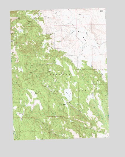
Clover Flat, OR USGS Topographic Map
Click on map above to begin viewing in our Map Viewer.

This topographic map contains these locations and features:
Feature Name Type Latitude Longitude GNIS ID View Map
Bear FlatFlatN42.4188°W120.4733°1117376View Map
Buck SpringSpringN42.4918°W120.4911°1118216View Map
Clover FlatFlatN42.4879°W120.4119°1139850View Map
Clover Flat Post Office (historical)Post OfficeN42.4552°W120.4052°1164277View Map
Counts RanchLocaleN42.4549°W120.4227°1167174View Map
Cox Pass TrailheadLocaleN42.3850°W120.3779°2548761View Map
Fir SpringSpringN42.3816°W120.4528°1120736View Map
Green CreekStreamN42.4646°W120.3872°1121372View Map
Mill FlatFlatN42.4157°W120.3961°1124173View Map
Mill Flat CreekStreamN42.4360°W120.3833°1124174View Map
Moss FlatSwampN42.4172°W120.4280°1124394View Map
Moss Flat SpringSpringN42.4068°W120.4319°1131003View Map
Moss PassGapN42.4710°W120.4989°1124397View Map
North Fork Cox CreekStreamN42.3838°W120.3983°1124763View Map
O'Leary ReservoirReservoirN42.4969°W120.3832°1124890View Map
Paxton MeadowsFlatN42.3985°W120.4891°1125245View Map
Red Knoll ReservoirReservoirN42.4961°W120.3756°1125885View Map
Whitaker (historical)LocaleN42.4693°W120.4344°1131002View Map

Note: Coordinates in the location and feature list above are referenced to NAD83 datum.


Copyright (C) 2008-2024 Ryan Niemi / Sunset Dynamics ... All Rights Reserved