TopoQuest Logo
Do you find TopoQuest useful?
Help keep TopoQuest running and adding new maps/features by donating!
Bitcoin:  19c7KJd3qBynnjoSw5npx9KScwjBe4ifkT
Litecoin:  LXs6TkuXGGXo1vDsWCkWVdjQX94eUKd6ui
Home View Maps Find Maps Find Places Resources & Links


Van Raub, Texas Topographic Map

USGS Map Title: Van Raub, TX
USGS Map MRC: 29098F6
DRG (GeoTIFF) Download: o29098f6.tif


Neighboring USGS Topographic Map Quads:


  Ranger Creek, TX  
29098G7
 

  Boerne, TX  
29098G6
 

  Bergheim, TX  
29098G5
 

  Jack Mountain, TX  
29098F7
 

  Van Raub, TX  
29098F6
 

  Camp Bullis, TX  
29098F5
 

  San Geronimo, TX  
29098E7
 

  Helotes, TX  
29098E6
 

  Castle Hills, TX  
29098E5


Map MRC Location:

N30°
W99°
N30°
W98°
H8 H7 H6 H5 H4 H3 H2 H1
G8 G7 G6 G5 G4 G3 G2 G1
F8 F7 F6 F5 F4 F3 F2 F1
E8 E7 E6 E5 E4 E3 E2 E1
D8 D7 D6 D5 D4 D3 D2 D1
C8 C7 C6 C5 C4 C3 C2 C1
B8 B7 B6 B5 B4 B3 B2 B1
A8 A7 A6 A5 A4 A3 A2 A1
N29°
W99°
N29°
W98°

Van Raub, TX USGS 1:24K Topographic Map Preview:
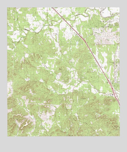
Van Raub, TX USGS Topographic Map
Click on map above to begin viewing in our Map Viewer.

This topographic map contains these locations and features:
Feature Name Type Latitude Longitude GNIS ID View Map
Aue Stagecoach InnBuildingN29.6663°W98.6303°2031545View Map
Balcones Community CenterBuildingN29.7338°W98.7034°1329966View Map
Balcones CreekStreamN29.7455°W98.6464°1372376View Map
Boerne Stage FieldAirportN29.7236°W98.6947°1387465View Map
Charles Cole CemeteryCemeteryN29.7475°W98.7435°2498957View Map
City of Fair Oaks RanchCivilN29.7452°W98.6400°2410473View Map
City of Fair Oaks Ranch Fire Station 2BuildingN29.7341°W98.6436°2552253View Map
Cole - Hugman CemeteryCemeteryN29.7250°W98.7467°2498937View Map
Concept Therapy InstituteSchoolN29.6816°W98.6678°1333200View Map
Cross MountainSummitN29.6630°W98.6664°1333717View Map
Cross MountainPopulated PlaceN29.6455°W98.6595°1867546View Map
Cross Mountain Census Designated PlaceCensusN29.6535°W98.6564°2407686View Map
Cross Mountain ChurchChurchN29.6746°W98.6566°2469604View Map
Fair Oaks RanchPopulated PlaceN29.7458°W98.6434°1377746View Map
Fair Oaks Ranch Municipal OfficesBuildingN29.7306°W98.6260°2753677View Map
Fair Oaks Ranch Police DepartmentBuildingN29.7305°W98.6262°2739225View Map
First Baptist Church of Leon SpringsChurchN29.6663°W98.6309°2016278View Map
Friedrich ParkParkN29.6369°W98.6320°1376969View Map
Friedrich Wilderness Park Trail NetworkTrailN29.6369°W98.6320°2032754View Map
Interchange 546CrossingN29.7194°W98.6660°2469948View Map
Interchange 550CrossingN29.6791°W98.6381°2469949View Map
Interchange 554CrossingN29.6596°W98.6272°2469950View Map
Kremkau DivideRidgeN29.6472°W98.6803°1339235View Map
KSAQ-FM (San Antonio)TowerN29.6336°W98.6309°1388077View Map
Lakeside Acres Club LakeReservoirN29.7151°W98.6726°1863452View Map
Lakeside Acres Club Lake DamDamN29.7152°W98.6720°1863451View Map
Leon SpringsPopulated PlaceN29.6649°W98.6292°1339823View Map
Leon Springs Elementary SchoolSchoolN29.6605°W98.6289°2003150View Map
Leon Springs Volunteer Fire DepartmentBuildingN29.6713°W98.6306°2469833View Map
McFarland HillSummitN29.6966°W98.6300°1341199View Map
Morales SpringSpringN29.6417°W98.7406°1341893View Map
Pecan CreekStreamN29.6711°W98.6845°1343760View Map
Plehwe ComplexBuildingN29.6652°W98.6364°2031730View Map
Postoak CreekStreamN29.7430°W98.6309°1375544View Map
Robles CemeteryCemeteryN29.6447°W98.6728°1345343View Map
Round HillSummitN29.6902°W98.6917°1345660View Map
Rundale CreekStreamN29.7169°W98.7406°1345747View Map
Saint Elizabeth Ann Seton Catholic ChurchChurchN29.6766°W98.6331°2016039View Map
San Antonio Fire Department Station 47BuildingN29.6491°W98.6262°2552385View Map
Scenic OaksPopulated PlaceN29.7108°W98.6759°1867564View Map
Scenic Oaks Census Designated PlaceCensusN29.7038°W98.6713°2409290View Map
Tarry Bank AirportAirportN29.6916°W98.7075°1387074View Map
Van RaubPopulated PlaceN29.7297°W98.6559°1379205View Map
White Company LakeReservoirN29.6429°W98.7218°1863454View Map
White Company Lake DamDamN29.6419°W98.7203°1863453View Map

Note: Coordinates in the location and feature list above are referenced to NAD83 datum.


Copyright (C) 2008-2025 Ryan Niemi / Sunset Dynamics ... All Rights Reserved