TopoQuest Logo
Do you find TopoQuest useful?
Help keep TopoQuest running and adding new maps/features by donating!
Bitcoin:  19c7KJd3qBynnjoSw5npx9KScwjBe4ifkT
Litecoin:  LXs6TkuXGGXo1vDsWCkWVdjQX94eUKd6ui
Home View Maps Find Maps Find Places Resources & Links


Boerne, Texas Topographic Map

USGS Map Title: Boerne, TX
USGS Map MRC: 29098G6
DRG (GeoTIFF) Download: o29098g6.tif


Neighboring USGS Topographic Map Quads:


  Waring, TX  
29098H7
 

  Sisterdale, TX  
29098H6
 

  Kendalia, TX  
29098H5
 

  Ranger Creek, TX  
29098G7
 

  Boerne, TX  
29098G6
 

  Bergheim, TX  
29098G5
 

  Jack Mountain, TX  
29098F7
 

  Van Raub, TX  
29098F6
 

  Camp Bullis, TX  
29098F5


Map MRC Location:

N30°
W99°
N30°
W98°
H8 H7 H6 H5 H4 H3 H2 H1
G8 G7 G6 G5 G4 G3 G2 G1
F8 F7 F6 F5 F4 F3 F2 F1
E8 E7 E6 E5 E4 E3 E2 E1
D8 D7 D6 D5 D4 D3 D2 D1
C8 C7 C6 C5 C4 C3 C2 C1
B8 B7 B6 B5 B4 B3 B2 B1
A8 A7 A6 A5 A4 A3 A2 A1
N29°
W99°
N29°
W98°

Boerne, TX USGS 1:24K Topographic Map Preview:
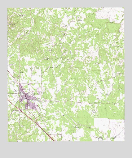
Boerne, TX USGS Topographic Map
Click on map above to begin viewing in our Map Viewer.

This topographic map contains these locations and features:
Feature Name Type Latitude Longitude GNIS ID View Map
Assembly of God ChurchChurchN29.7799°W98.7178°2041419View Map
Benedictine ConventChurchN29.7841°W98.7331°2043374View Map
Black CreekStreamN29.8599°W98.6295°1352308View Map
BoernePopulated PlaceN29.7947°W98.7320°1352557View Map
Boerne City Municipal OfficesBuildingN29.7961°W98.7296°2753397View Map
Boerne City ParkParkN29.7841°W98.7111°2028760View Map
Boerne Community CenterBuildingN29.8055°W98.7242°2037054View Map
Boerne DivisionCivilN29.8351°W98.7288°1938547View Map
Boerne Fire DepartmentBuildingN29.8005°W98.7357°2041427View Map
Boerne High SchoolSchoolN29.7980°W98.7145°2007078View Map
Boerne LibraryBuildingN29.7944°W98.7325°2044355View Map
Boerne Middle SchoolSchoolN29.7958°W98.7361°2007014View Map
Boerne Middle School NorthSchoolN29.7961°W98.7375°2041433View Map
Boerne Middle School SouthSchoolN29.7591°W98.6942°2041424View Map
Boerne Park LakeReservoirN29.7886°W98.7236°1859622View Map
Boerne Police DepartmentBuildingN29.7659°W98.7126°2041937View Map
Boerne Post OfficePost OfficeN29.7960°W98.7275°2041938View Map
Boerne State Park DamDamN29.7886°W98.7236°1859621View Map
Browns CreekStreamN29.7741°W98.6984°1352996View Map
BYAA Merchant FieldParkN29.7969°W98.7403°2027959View Map
Church of ChristChurchN29.7780°W98.7372°2043375View Map
Cibolo Nature Center TrailTrailN29.7752°W98.7086°2032886View Map
City of BoerneCivilN29.7847°W98.7297°2409874View Map
Curington Elementary SchoolSchoolN29.8049°W98.7292°2007018View Map
Currey CreekStreamN29.7869°W98.7150°1355483View Map
Currey Creek Baptist ChurchChurchN29.7561°W98.6942°2041423View Map
Electric SubstationBuildingN29.8044°W98.7259°2041425View Map
Fabra Elementary SchoolSchoolN29.7948°W98.7360°2007019View Map
First Baptist ChurchChurchN29.7836°W98.7372°2043373View Map
First United Methodist ChurchChurchN29.8086°W98.7292°2041940View Map
Frederick CreekStreamN29.7894°W98.7322°1357700View Map
Grier AirportAirportN29.8733°W98.7307°1386261View Map
Herff Park FairgroundLocaleN29.7874°W98.7075°1359071View Map
Howard CemeteryCemeteryN29.7627°W98.7089°2493777View Map
Jehovahs Witnesses of BoerneChurchN29.7941°W98.7370°2043369View Map
Jesus Name Full Gospel ChurchChurchN29.7927°W98.7261°2041939View Map
John Henry Key AirportAirportN29.8511°W98.7358°2675876View Map
Joseph Dienger BuildingBuildingN29.7947°W98.7322°2030896View Map
KBRN-AM (Boerne)TowerN29.8124°W98.7284°1385507View Map
Kendall County Constable's Office Precinct 3BuildingN29.8063°W98.7232°2750607View Map
Kendall County Constable's Office Precincts 1 and 2BuildingN29.7940°W98.7306°2750606View Map
Kendall County CourthouseBuildingN29.7941°W98.7309°2030651View Map
Kendall County Emergency Medical ServiceBuildingN29.8082°W98.7418°2655835View Map
Kendall County EMSBuildingN29.8102°W98.7403°2041936View Map
Kendall County Law Enforcement CenterBuildingN29.8062°W98.7230°2041426View Map
Kendall County Sheriff's OfficeBuildingN29.8063°W98.7229°2750485View Map
Kendall Elementary SchoolSchoolN29.7661°W98.7075°2041422View Map
Kendall InnBuildingN29.7941°W98.7336°2030832View Map
KreutzbergPopulated PlaceN29.8636°W98.6753°1380042View Map
Kreutzberg CemeteryCemeteryN29.8586°W98.6881°1365144View Map
Kulmann-King HouseBuildingN29.7955°W98.7300°2014541View Map
Malakopf HillSummitN29.8274°W98.7086°1362111View Map
Menger CreekStreamN29.7752°W98.7089°1374880View Map
Panther Creek School (historical)SchoolN29.8136°W98.6287°2663994View Map
Pleasant Valley Community CenterBuildingN29.8136°W98.6288°1365457View Map
Pleasant Valley School (historical)SchoolN29.8136°W98.6289°2663993View Map
Rock CreekStreamN29.8513°W98.6300°1366638View Map
Sabinas MountainSummitN29.8597°W98.7459°1367081View Map
Saint Helenas Episcopal ChurchChurchN29.7988°W98.7345°2022641View Map
Saint John Lutheran ChurchChurchN29.7933°W98.7292°2022642View Map
Saint Johns Anglican ChurchChurchN29.8091°W98.7411°2022640View Map
Saint Mark Presbyterian ChurchChurchN29.7805°W98.7314°2022644View Map
Saint Peter the Apostle Catholic ChurchChurchN29.7852°W98.7300°2041941View Map
Smith HillSummitN29.8505°W98.6909°1368488View Map
The Church of Jesus Christ of Latter Day SaintsChurchN29.7986°W98.7164°2022643View Map
Walnut GrovePopulated PlaceN29.8683°W98.7347°1380737View Map
Wrenn CemeteryCemeteryN29.8263°W98.6919°2492037View Map

Note: Coordinates in the location and feature list above are referenced to NAD83 datum.


Copyright (C) 2008-2025 Ryan Niemi / Sunset Dynamics ... All Rights Reserved