TopoQuest Logo
Do you find TopoQuest useful?
Help keep TopoQuest running and adding new maps/features by donating!
Bitcoin:  19c7KJd3qBynnjoSw5npx9KScwjBe4ifkT
Litecoin:  LXs6TkuXGGXo1vDsWCkWVdjQX94eUKd6ui
Home View Maps Find Maps Find Places Resources & Links


Vanoss, Oklahoma Topographic Map

USGS Map Title: Vanoss, OK
USGS Map MRC: 34096G7
DRG (GeoTIFF) Download: o34096g7.tif


Neighboring USGS Topographic Map Quads:


  Asher, OK  
34096H8
 

  Konawa, OK  
34096H7
 

  Vamoosa, OK  
34096H6
 

  Stratford, OK  
34096G8
 

  Vanoss, OK  
34096G7
 

  Ada, OK  
34096G6
 

  Hart, OK  
34096F8
 

  Roff North, OK  
34096F7
 

  Ahloso, OK  
34096F6


Map MRC Location:

N35°
W97°
N35°
W96°
H8 H7 H6 H5 H4 H3 H2 H1
G8 G7 G6 G5 G4 G3 G2 G1
F8 F7 F6 F5 F4 F3 F2 F1
E8 E7 E6 E5 E4 E3 E2 E1
D8 D7 D6 D5 D4 D3 D2 D1
C8 C7 C6 C5 C4 C3 C2 C1
B8 B7 B6 B5 B4 B3 B2 B1
A8 A7 A6 A5 A4 A3 A2 A1
N34°
W97°
N34°
W96°

Vanoss, OK USGS 1:24K Topographic Map Preview:
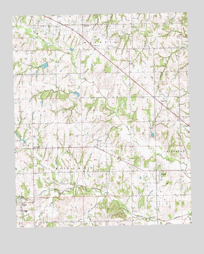
Vanoss, OK USGS Topographic Map
Click on map above to begin viewing in our Map Viewer.

This topographic map contains these locations and features:
Feature Name Type Latitude Longitude GNIS ID View Map
BebeePopulated PlaceN34.8451°W96.7917°1100198View Map
Bebee-Southwest Konawa Oil and Gas FieldOilfieldN34.8645°W96.8320°1089950View Map
Black CreekStreamN34.7545°W96.7528°1090194View Map
Box X CemeteryCemeteryN34.8562°W96.8061°1090438View Map
Burris CreekStreamN34.7695°W96.8436°1090731View Map
CenterPopulated PlaceN34.7993°W96.8156°1091140View Map
Center CemeteryCemeteryN34.8034°W96.8320°1091141View Map
Center Volunteer Fire DepartmentBuildingN34.7980°W96.8150°2657433View Map
Coon CreekStreamN34.7737°W96.8328°1091636View Map
East Days CreekStreamN34.7562°W96.8236°1092387View Map
Freewill Baptist ChurchChurchN34.8567°W96.8178°1093041View Map
Gaar CornerPopulated PlaceN34.7968°W96.8620°1100438View Map
Moss CemeteryCemeteryN34.7672°W96.8553°2711560View Map
Northeast Bebee Oil and Gas FieldOilfieldN34.8687°W96.7606°1096015View Map
Northwest Pontotoc DivisionCivilN34.8054°W96.8374°1937809View Map
Oil CenterPopulated PlaceN34.8687°W96.8242°1096184View Map
Oil Center Fire DepartmentBuildingN34.8656°W96.8255°2657434View Map
Oknoname 123004 DamDamN34.8417°W96.8586°1753457View Map
Oknoname 123004 ReservoirReservoirN34.8417°W96.8584°1753458View Map
Oknoname 123005 DamDamN34.8134°W96.7920°1753459View Map
Oknoname 123005 ReservoirReservoirN34.8134°W96.7906°1753460View Map
PickettPopulated PlaceN34.7820°W96.7747°1096620View Map
Pickett - Center Elementary SchoolSchoolN34.7843°W96.7809°1790531View Map
Pickett Center Volunteer Fire DepartmentBuildingN34.7782°W96.7767°2657432View Map
Sandy Creek Site 20 DamDamN34.8001°W96.8686°1757103View Map
Sandy Creek Site 20 ReservoirReservoirN34.8018°W96.8707°1757104View Map
Sandy Creek Site 21 DamDamN34.7968°W96.8586°1757105View Map
Sandy Creek Site 21 ReservoirReservoirN34.7968°W96.8586°1757106View Map
Sandy Creek Site 22 DamDamN34.8284°W96.8303°1757107View Map
Sandy Creek Site 22 ReservoirReservoirN34.8285°W96.8308°1757108View Map
Sandy Creek Site 23 DamDamN34.8467°W96.8503°1757109View Map
Sandy Creek Site 23 ReservoirReservoirN34.8454°W96.8526°1757110View Map
Sandy Creek Site 29 DamDamN34.8551°W96.8336°1757111View Map
Sandy Creek Site 29 ReservoirReservoirN34.8547°W96.8332°1757112View Map
Sandy Creek Site 30 DamDamN34.8034°W96.7770°1757113View Map
Sandy Creek Site 30 ReservoirReservoirN34.8035°W96.7768°1757114View Map
Sandy Creek Site 31 DamDamN34.7901°W96.7503°1757115View Map
Southeast Oil and Gas FieldOilfieldN34.8312°W96.7736°1098298View Map
Township of MidlandCivilN34.7779°W96.8364°1824974View Map
Union HillPopulated PlaceN34.8229°W96.7658°1099166View Map
VanossPopulated PlaceN34.7640°W96.8720°1099228View Map
Vanoss Elementary SchoolSchoolN34.7591°W96.8682°1790532View Map
Vanoss Fire DepartmentBuildingN34.7647°W96.8708°2657304View Map
Vanoss High SchoolSchoolN34.7597°W96.8683°1790244View Map
West Days CreekStreamN34.7690°W96.8097°1099538View Map

Note: Coordinates in the location and feature list above are referenced to NAD83 datum.


Copyright (C) 2008-2025 Ryan Niemi / Sunset Dynamics ... All Rights Reserved