TopoQuest Logo
Do you find TopoQuest useful?
Help keep TopoQuest running and adding new maps/features by donating!
Bitcoin:  19c7KJd3qBynnjoSw5npx9KScwjBe4ifkT
Litecoin:  LXs6TkuXGGXo1vDsWCkWVdjQX94eUKd6ui
Home View Maps Find Maps Find Places Resources & Links


Stratford, Oklahoma Topographic Map

USGS Map Title: Stratford, OK
USGS Map MRC: 34096G8
DRG (GeoTIFF) Download: o34096g8.tif


Neighboring USGS Topographic Map Quads:


  Wanette, OK  
34097H1
 

  Asher, OK  
34096H8
 

  Konawa, OK  
34096H7
 

  Byars, OK  
34097G1
 

  Stratford, OK  
34096G8
 

  Vanoss, OK  
34096G7
 

  Pauls Valley NE, OK  
34097F1
 

  Hart, OK  
34096F8
 

  Roff North, OK  
34096F7


Map MRC Location:

N35°
W97°
N35°
W96°
H8 H7 H6 H5 H4 H3 H2 H1
G8 G7 G6 G5 G4 G3 G2 G1
F8 F7 F6 F5 F4 F3 F2 F1
E8 E7 E6 E5 E4 E3 E2 E1
D8 D7 D6 D5 D4 D3 D2 D1
C8 C7 C6 C5 C4 C3 C2 C1
B8 B7 B6 B5 B4 B3 B2 B1
A8 A7 A6 A5 A4 A3 A2 A1
N34°
W97°
N34°
W96°

Stratford, OK USGS 1:24K Topographic Map Preview:
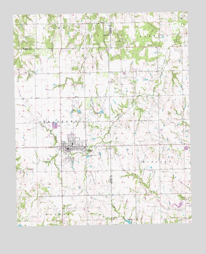
Stratford, OK USGS Topographic Map
Click on map above to begin viewing in our Map Viewer.

This topographic map contains these locations and features:
Feature Name Type Latitude Longitude GNIS ID View Map
Cherokee Sandy Site 8a DamDamN34.7501°W96.9903°1758404View Map
Cherokee Sandy Site 8a ReservoirReservoirN34.7501°W96.9903°1758405View Map
Diamond C Ranch AirportAirportN34.7751°W96.9285°1102681View Map
McGeePopulated PlaceN34.8256°W96.9572°1100616View Map
McGee CemeteryCemeteryN34.8225°W96.9556°2708962View Map
Midland CemeteryCemeteryN34.7534°W96.8850°1095370View Map
Sandy Creek Site 17 DamDamN34.7518°W96.9186°1757099View Map
Sandy Creek Site 17 ReservoirReservoirN34.7516°W96.9205°1757100View Map
Sandy Creek Site 18 DamDamN34.7619°W96.8823°1751892View Map
Sandy Creek Site 18 ReservoirReservoirN34.7599°W96.8855°1751893View Map
Sandy Creek Site 19 DamDamN34.7949°W96.8775°1757101View Map
Sandy Creek Site 19 ReservoirReservoirN34.7943°W96.8787°1757102View Map
Sandy Creek Site 27 DamDamN34.8167°W96.9536°1759014View Map
Sandy Creek Site 27 ReservoirReservoirN34.8174°W96.9544°1759015View Map
Sandy Creek Site 28 DamDamN34.8167°W96.9370°1759016View Map
Sandy Creek Site 28 ReservoirReservoirN34.8168°W96.9385°1759017View Map
Shady Grove ChurchChurchN34.8620°W96.9300°1097940View Map
Southeast Stratford Oil FieldOilfieldN34.7779°W96.9461°1098305View Map
StratfordPopulated PlaceN34.7967°W96.9595°1098579View Map
Stratford AmbulanceBuildingN34.7958°W96.9620°2695875View Map
Stratford Elementary SchoolSchoolN34.7976°W96.9595°1790730View Map
Stratford Fire DepartmentBuildingN34.7937°W96.9619°2658277View Map
Stratford High SchoolSchoolN34.7988°W96.9595°2712797View Map
Stratford Middle SchoolSchoolN34.7982°W96.9595°1819369View Map
Stratford Police DepartmentBuildingN34.7958°W96.9621°2757471View Map
Town of StratfordCivilN34.7952°W96.9603°2413340View Map

Note: Coordinates in the location and feature list above are referenced to NAD83 datum.


Copyright (C) 2008-2025 Ryan Niemi / Sunset Dynamics ... All Rights Reserved