TopoQuest Logo
Do you find TopoQuest useful?
Help keep TopoQuest running and adding new maps/features by donating!
Bitcoin:  19c7KJd3qBynnjoSw5npx9KScwjBe4ifkT
Litecoin:  LXs6TkuXGGXo1vDsWCkWVdjQX94eUKd6ui
Home View Maps Find Maps Find Places Resources & Links


Vass, North Carolina Topographic Map

USGS Map Title: Vass, NC
USGS Map MRC: 35079C3
DRG (GeoTIFF) Download: o35079c3.tif


Neighboring USGS Topographic Map Quads:


  Putnam, NC  
35079D4
 

  White Hill, NC  
35079D3
 

  Sanford, NC  
35079D2
 

  Carthage, NC  
35079C4
 

  Vass, NC  
35079C3
 

  Murchisontown, NC  
35079C2
 

  Southern Pines, NC  
35079B4
 

  Niagara, NC  
35079B3
 

  Lobelia, NC  
35079B2


Map MRC Location:

N36°
W80°
N36°
W79°
H8 H7 H6 H5 H4 H3 H2 H1
G8 G7 G6 G5 G4 G3 G2 G1
F8 F7 F6 F5 F4 F3 F2 F1
E8 E7 E6 E5 E4 E3 E2 E1
D8 D7 D6 D5 D4 D3 D2 D1
C8 C7 C6 C5 C4 C3 C2 C1
B8 B7 B6 B5 B4 B3 B2 B1
A8 A7 A6 A5 A4 A3 A2 A1
N35°
W80°
N35°
W79°

Vass, NC USGS 1:24K Topographic Map Preview:
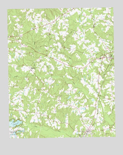
Vass, NC USGS Topographic Map
Click on map above to begin viewing in our Map Viewer.

This topographic map contains these locations and features:
Feature Name Type Latitude Longitude GNIS ID View Map
Big BranchStreamN35.2677°W79.2611°981361View Map
CameronPopulated PlaceN35.3268°W79.2553°1019484View Map
Cameron Elementary SchoolSchoolN35.3265°W79.2661°1006737View Map
Cameron Police DepartmentBuildingN35.3268°W79.2549°2769662View Map
Cameron Post OfficePost OfficeN35.3265°W79.2538°2774084View Map
Cameron Rural Fire DepartmentBuildingN35.3270°W79.2715°2639318View Map
Circle V Fire Department Station 1BuildingN35.2550°W79.2809°2638899View Map
Crane Creek CemeteryCemeteryN35.3018°W79.2825°983715View Map
Dunhams CreekStreamN35.3110°W79.3406°984431View Map
Halls ChurchChurchN35.2860°W79.3156°986322View Map
Henderson CemeteryCemeteryN35.2904°W79.3156°986609View Map
Herds CreekStreamN35.2996°W79.2922°986637View Map
Hood ChapelChurchN35.3282°W79.2536°987020View Map
Johnson Grove CemeteryCemeteryN35.2529°W79.2620°987680View Map
Lamn Grove ChurchChurchN35.3674°W79.3078°988119View Map
Little Crane CreekStreamN35.2849°W79.2678°988580View Map
Moore County Emergency Medical Services Base 2BuildingN35.3197°W79.3479°2720473View Map
Moore County Emergency Medical Services Base 8BuildingN35.2554°W79.2804°2720479View Map
Morses LakeReservoirN35.2888°W79.3037°998754View Map
Morses Lake DamDamN35.2902°W79.3031°998755View Map
Mount Zion ChurchChurchN35.3499°W79.3267°990642View Map
Pine LakeReservoirN35.2540°W79.3695°992261View Map
Pine Lake DamDamN35.2568°W79.3681°998672View Map
Red Hill ChurchChurchN35.3354°W79.3028°993118View Map
Shadow LakeReservoirN35.2574°W79.3610°994529View Map
Shadow Lake DamDamN35.2571°W79.3573°998675View Map
Stones ChapelChurchN35.3557°W79.3442°995541View Map
Thagads Lake DamDamN35.2649°W79.3609°998694View Map
Thagards LakeReservoirN35.2650°W79.3703°995951View Map
Thurlows LakeReservoirN35.2779°W79.2865°998721View Map
Thurlows Lake DamDamN35.2768°W79.2847°998722View Map
Town of CameronCivilN35.3259°W79.2542°2405369View Map
Town of VassCivilN35.2533°W79.2846°2406796View Map
Township 6-GreenwoodCivilN35.3287°W79.2772°1026972View Map
Troy Lumber Company DamDamN35.2535°W79.2947°998663View Map
Union ChurchChurchN35.3163°W79.3478°996455View Map
Union Pines High SchoolSchoolN35.3177°W79.3467°996509View Map
VassPopulated PlaceN35.2563°W79.2822°1023075View Map
Vass Police DepartmentBuildingN35.2551°W79.2815°2769754View Map
Vass Post OfficePost OfficeN35.2563°W79.2818°2774116View Map
Vass Rescue SquadBuildingN35.2554°W79.2803°2720557View Map
Vass-Lakeview SchoolSchoolN35.2515°W79.2920°996596View Map
Whispering PinesPopulated PlaceN35.2557°W79.3723°1023195View Map
Whispering Pines Police DepartmentBuildingN35.2585°W79.3689°2769668View Map

Note: Coordinates in the location and feature list above are referenced to NAD83 datum.


Copyright (C) 2008-2025 Ryan Niemi / Sunset Dynamics ... All Rights Reserved