TopoQuest Logo
Do you find TopoQuest useful?
Help keep TopoQuest running and adding new maps/features by donating!
Bitcoin:  19c7KJd3qBynnjoSw5npx9KScwjBe4ifkT
Litecoin:  LXs6TkuXGGXo1vDsWCkWVdjQX94eUKd6ui
Home View Maps Find Maps Find Places Resources & Links


Verona, Wisconsin Topographic Map

USGS Map Title: Verona, WI
USGS Map MRC: 42089H5
DRG (GeoTIFF) Download: o42089h5.tif


Neighboring USGS Topographic Map Quads:


  Cross Plains, WI  
43089A6
 

  Middleton, WI  
43089A5
 

  Madison West, WI  
43089A4
 

  Mount Vernon, WI  
42089H6
 

  Verona, WI  
42089H5
 

  Oregon, WI  
42089H4
 

  New Glarus, WI  
42089G6
 

  Belleville, WI  
42089G5
 

  Attica, WI  
42089G4


Map MRC Location:

N43°
W90°
N43°
W89°
H8 H7 H6 H5 H4 H3 H2 H1
G8 G7 G6 G5 G4 G3 G2 G1
F8 F7 F6 F5 F4 F3 F2 F1
E8 E7 E6 E5 E4 E3 E2 E1
D8 D7 D6 D5 D4 D3 D2 D1
C8 C7 C6 C5 C4 C3 C2 C1
B8 B7 B6 B5 B4 B3 B2 B1
A8 A7 A6 A5 A4 A3 A2 A1
N42°
W90°
N42°
W89°

Verona, WI USGS 1:24K Topographic Map Preview:
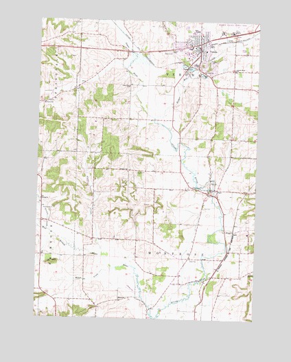
Verona, WI USGS Topographic Map
Click on map above to begin viewing in our Map Viewer.

This topographic map contains these locations and features:
Feature Name Type Latitude Longitude GNIS ID View Map
Badger Mill CreekStreamN42.9592°W89.5585°1561071View Map
Badger Mill HillSummitN42.9819°W89.5321°1842311View Map
Badger Prairie County ParkParkN42.9992°W89.5137°1842312View Map
Badger Ridge Middle SchoolSchoolN42.9993°W89.5358°1561076View Map
BascoPopulated PlaceN42.9119°W89.5148°1561217View Map
City of VeronaCivilN42.9880°W89.5372°1584328View Map
Core Knowledge Charter SchoolSchoolN42.9997°W89.5356°2716530View Map
Dane County Farm (historical)LocaleN42.9953°W89.5148°1842370View Map
Fitch - Rona Emergency Medical Services SubstationBuildingN42.9832°W89.5405°2698255View Map
Flynn CreekStreamN42.9014°W89.5876°1565091View Map
Frenchtown CemeteryCemeteryN42.8950°W89.5028°2781255View Map
Glacier Edge Elementary SchoolSchoolN42.9779°W89.5177°1560864View Map
Harker SchoolSchoolN42.9247°W89.6223°1566068View Map
McPherson SchoolSchoolN42.9656°W89.6221°1569274View Map
Milum CreekStreamN42.8983°W89.5757°1569535View Map
MontrosePopulated PlaceN42.8828°W89.5773°1577733View Map
Montrose Pioneer CemeteryCemeteryN42.8865°W89.5779°2781271View Map
Mount JuliaSummitN42.8981°W89.6160°1569819View Map
Mount Vernon CreekStreamN42.9122°W89.6190°1569858View Map
New Century SchoolSchoolN42.9893°W89.5381°2716175View Map
Olson Oak Woods State Natural AreaParkN42.9481°W89.5835°1989929View Map
PaoliPopulated PlaceN42.9294°W89.5237°1571009View Map
Paoli CemeteryCemeteryN42.9218°W89.5300°1571010View Map
Saint Andrew Catholic CemeteryCemeteryN42.9977°W89.5325°2765636View Map
Saint William Catholic CemeteryCemeteryN42.9360°W89.5679°1573601View Map
Schaller SchoolSchoolN42.9375°W89.5779°1573776View Map
Sugar Creek Elementary SchoolSchoolN42.9883°W89.5394°1842703View Map
Sugar Ridge AirportAirportN42.9636°W89.5810°1582245View Map
Sugar River Wetlands State Natural AreaParkN42.9847°W89.5668°1989931View Map
Town of MontroseCivilN42.9021°W89.5444°1583750View Map
Town of VeronaCivilN42.9686°W89.5733°1584329View Map
Valley View SchoolSchoolN42.9728°W89.5735°1576024View Map
VeronaPopulated PlaceN42.9908°W89.5332°1576068View Map
Verona AirportAirportN42.9891°W89.5113°1582246View Map
Verona Area High SchoolSchoolN42.9953°W89.5375°1842732View Map
Verona Area Middle SchoolSchoolN42.9961°W89.5351°1842733View Map
Verona CemeteryCemeteryN42.9965°W89.5324°2781236View Map
Verona Fire DepartmentBuildingN42.9916°W89.5279°2697841View Map
Verona Police DepartmentBuildingN42.9896°W89.5273°2759511View Map

Note: Coordinates in the location and feature list above are referenced to NAD83 datum.


Copyright (C) 2008-2024 Ryan Niemi / Sunset Dynamics ... All Rights Reserved