TopoQuest Logo
Do you find TopoQuest useful?
Help keep TopoQuest running and adding new maps/features by donating!
Bitcoin:  19c7KJd3qBynnjoSw5npx9KScwjBe4ifkT
Litecoin:  LXs6TkuXGGXo1vDsWCkWVdjQX94eUKd6ui
Home View Maps Find Maps Find Places Resources & Links


Belleville, Wisconsin Topographic Map

USGS Map Title: Belleville, WI
USGS Map MRC: 42089G5
DRG (GeoTIFF) Download: o42089g5.tif


Neighboring USGS Topographic Map Quads:


  Mount Vernon, WI  
42089H6
 

  Verona, WI  
42089H5
 

  Oregon, WI  
42089H4
 

  New Glarus, WI  
42089G6
 

  Belleville, WI  
42089G5
 

  Attica, WI  
42089G4
 

  Monroe NW, WI  
42089F6
 

  Monticello, WI  
42089F5
 

  Albany, WI  
42089F4


Map MRC Location:

N43°
W90°
N43°
W89°
H8 H7 H6 H5 H4 H3 H2 H1
G8 G7 G6 G5 G4 G3 G2 G1
F8 F7 F6 F5 F4 F3 F2 F1
E8 E7 E6 E5 E4 E3 E2 E1
D8 D7 D6 D5 D4 D3 D2 D1
C8 C7 C6 C5 C4 C3 C2 C1
B8 B7 B6 B5 B4 B3 B2 B1
A8 A7 A6 A5 A4 A3 A2 A1
N42°
W90°
N42°
W89°

Belleville, WI USGS 1:24K Topographic Map Preview:
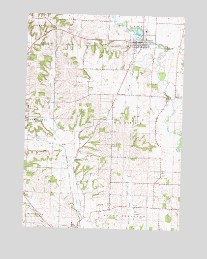
Belleville, WI USGS Topographic Map
Click on map above to begin viewing in our Map Viewer.

This topographic map contains these locations and features:
Feature Name Type Latitude Longitude GNIS ID View Map
Anderson DairyLocaleN42.7519°W89.5175°2723735View Map
BellevillePopulated PlaceN42.8597°W89.5382°1561535View Map
Belleville Area Emergency Medical ServicesBuildingN42.8681°W89.5315°2698430View Map
Belleville CemeteryCemeteryN42.8711°W89.5325°1561537View Map
Belleville Elementary SchoolSchoolN42.8589°W89.5377°1842320View Map
Belleville High SchoolSchoolN42.8577°W89.5461°1842319View Map
Belleville Intermediate SchoolSchoolN42.8587°W89.5414°2716528View Map
Belleville Middle SchoolSchoolN42.8580°W89.5454°2716433View Map
Belleville Police DepartmentBuildingN42.8598°W89.5329°2759591View Map
Belleville Volunteer Fire DepartmentBuildingN42.8598°W89.5328°2697711View Map
Belleville WP90-18 DamDamN42.8617°W89.5335°1791888View Map
DaytonPopulated PlaceN42.8269°W89.5132°1563749View Map
ExeterPopulated PlaceN42.7810°W89.5162°2760450View Map
ExeterPopulated PlaceN42.7906°W89.5832°1577592View Map
Exeter CemeteryCemeteryN42.7844°W89.5167°1564787View Map
First United Church of ChristChurchN42.8575°W89.5318°1842426View Map
Grace United Methodist ChurchChurchN42.8583°W89.5379°1842443View Map
Lake Belle ViewReservoirN42.8645°W89.5372°1561534View Map
Monticello Fire DepartmentBuildingN42.7502°W89.5939°2697742View Map
Ross CrossingPopulated PlaceN42.8292°W89.5523°1577799View Map
Ross Crossing CreekStreamN42.8489°W89.5210°1572622View Map
Saint James CemeteryCemeteryN42.8353°W89.5263°1572972View Map
Saint Mary of Lourdes ChurchChurchN42.8569°W89.5371°1842658View Map
Town of ExeterCivilN42.8133°W89.5447°1583182View Map
Village of BellevilleCivilN42.8642°W89.5402°1582786View Map
Ward CreekStreamN42.7986°W89.5965°1576203View Map
West Branch Sugar RiverStreamN42.8739°W89.5562°1576482View Map
Wettach FarmsLocaleN42.7700°W89.5939°2723739View Map

Note: Coordinates in the location and feature list above are referenced to NAD83 datum.


Copyright (C) 2008-2025 Ryan Niemi / Sunset Dynamics ... All Rights Reserved