TopoQuest Logo
Do you find TopoQuest useful?
Help keep TopoQuest running and adding new maps/features by donating!
Bitcoin:  19c7KJd3qBynnjoSw5npx9KScwjBe4ifkT
Litecoin:  LXs6TkuXGGXo1vDsWCkWVdjQX94eUKd6ui
Home View Maps Find Maps Find Places Resources & Links


Versailles, Illinois Topographic Map

USGS Map Title: Versailles, IL
USGS Map MRC: 39090H6
DRG (GeoTIFF) Download: o39090h6.tif


Neighboring USGS Topographic Map Quads:


  Lake Mount Sterling, IL  
40090A7
 

  Ripley, IL  
40090A6
 

  Rushville South, IL  
40090A5
 

  Mount Sterling, IL  
39090H7
 

  Versailles, IL  
39090H6
 

  Cooperstown, IL  
39090H5
 

  Perry West, IL  
39090G7
 

  Perry East, IL  
39090G6
 

  Meredosia, IL  
39090G5


Map MRC Location:

N40°
W91°
N40°
W90°
H8 H7 H6 H5 H4 H3 H2 H1
G8 G7 G6 G5 G4 G3 G2 G1
F8 F7 F6 F5 F4 F3 F2 F1
E8 E7 E6 E5 E4 E3 E2 E1
D8 D7 D6 D5 D4 D3 D2 D1
C8 C7 C6 C5 C4 C3 C2 C1
B8 B7 B6 B5 B4 B3 B2 B1
A8 A7 A6 A5 A4 A3 A2 A1
N39°
W91°
N39°
W90°

Versailles, IL USGS 1:24K Topographic Map Preview:
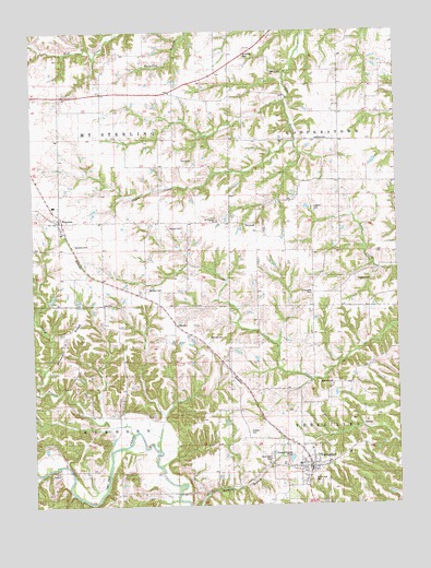
Versailles, IL USGS Topographic Map
Click on map above to begin viewing in our Map Viewer.

This topographic map contains these locations and features:
Feature Name Type Latitude Longitude GNIS ID View Map
Avery BranchStreamN39.8939°W90.7162°403758View Map
Barton School (historical)SchoolN39.9823°W90.6357°403948View Map
Casteen CemeteryCemeteryN39.8950°W90.6760°1720765View Map
Cross Roads CemeteryCemeteryN39.9306°W90.6546°1720771View Map
Crossroads School (historical)SchoolN39.9273°W90.6537°406838View Map
Dawson CemeteryCemeteryN39.8998°W90.6635°1985156View Map
Elias Clark CemeteryCemeteryN39.9414°W90.6326°1720766View Map
GilbirdsPopulated PlaceN39.9231°W90.7015°422735View Map
Gilbirds CemeteryCemeteryN39.9192°W90.6896°1720777View Map
Hambaugh-Martin Number Five ReservoirReservoirN39.8779°W90.6285°1692021View Map
Hambaugh-Martin Structure Number 5 DamDamN39.8784°W90.6268°1692020View Map
Harbour CemeteryCemeteryN39.9323°W90.7107°1720782View Map
Harper School (historical)SchoolN39.9500°W90.6965°409829View Map
Hazel Bell School (historical)SchoolN39.9867°W90.7199°409968View Map
HersmanPopulated PlaceN39.9500°W90.7412°410113View Map
Hersman CemeteryCemeteryN39.9439°W90.7362°1720784View Map
Hill School (historical)SchoolN39.9459°W90.6640°410266View Map
Howe School (historical)SchoolN39.9945°W90.6876°410622View Map
Huffman CemeteryCemeteryN39.9714°W90.6482°1720785View Map
Icabod Perry CemeteryCemeteryN39.9662°W90.6951°1720812View Map
JaquesPopulated PlaceN39.8839°W90.7432°422845View Map
Kleinlein Farm PondReservoirN39.9300°W90.7436°1691581View Map
Kleinlein Farm Pond DamDamN39.9300°W90.7451°1691580View Map
Law CemeteryCemeteryN39.9278°W90.7262°1720791View Map
Logan Creek CemeteryCemeteryN39.9898°W90.6673°1720796View Map
Logsdon Number 1 CemeteryCemeteryN39.9534°W90.6537°1720798View Map
Logsdon Number 2 CemeteryCemeteryN39.9342°W90.6393°1720797View Map
McDaniel School (historical)SchoolN39.9059°W90.6799°1720802View Map
Mount Pleasant ChurchChurchN39.9498°W90.6868°1720808View Map
North Bend School (historical)SchoolN39.8895°W90.7424°414562View Map
Patterson School (historical)SchoolN39.8792°W90.6949°415446View Map
Perry CemeteryCemeteryN39.9487°W90.6773°1720813View Map
Perry School (historical)SchoolN39.9717°W90.6665°415562View Map
Pleasant Hill School (historical)SchoolN39.9181°W90.7204°415849View Map
Putnam CemeteryCemeteryN39.9484°W90.7032°1720814View Map
Robison CemeteryCemeteryN39.9073°W90.6479°1720817View Map
Robison School (historical)SchoolN39.9109°W90.6404°416779View Map
South Side CemeteryCemeteryN39.8817°W90.6548°1720821View Map
Township of ElkhornCivilN39.8842°W90.7410°428954View Map
Township of Mount SterlingCivilN39.9723°W90.7399°429409View Map
VersaillesPopulated PlaceN39.8850°W90.6560°420277View Map
Versailles Fire Protection DistrictBuildingN39.8841°W90.6564°2640478View Map
Versailles Grade SchoolSchoolN39.8856°W90.6599°2040041View Map
Versailles Post OfficePost OfficeN39.8850°W90.6557°2788641View Map
Versailles SpringsSpringN39.8964°W90.6376°2040042View Map
Village of VersaillesCivilN39.8842°W90.6587°2400067View Map
West Side CemeteryCemeteryN39.8878°W90.6693°1720829View Map
Wheeler RidgeRidgeN39.9212°W90.7368°420996View Map

Note: Coordinates in the location and feature list above are referenced to NAD83 datum.


Copyright (C) 2008-2024 Ryan Niemi / Sunset Dynamics ... All Rights Reserved