TopoQuest Logo
Do you find TopoQuest useful?
Help keep TopoQuest running and adding new maps/features by donating!
Bitcoin:  19c7KJd3qBynnjoSw5npx9KScwjBe4ifkT
Litecoin:  LXs6TkuXGGXo1vDsWCkWVdjQX94eUKd6ui
Home View Maps Find Maps Find Places Resources & Links


Perry West, Illinois Topographic Map

USGS Map Title: Perry West, IL
USGS Map MRC: 39090G7
DRG (GeoTIFF) Download: o39090g7.tif


Neighboring USGS Topographic Map Quads:


  Kellerville, IL  
39090H8
 

  Mount Sterling, IL  
39090H7
 

  Versailles, IL  
39090H6
 

  Fishhook, IL  
39090G8
 

  Perry West, IL  
39090G7
 

  Perry East, IL  
39090G6
 

  Baylis, IL  
39090F8
 

  New Salem, IL  
39090F7
 

  Griggsville, IL  
39090F6


Map MRC Location:

N40°
W91°
N40°
W90°
H8 H7 H6 H5 H4 H3 H2 H1
G8 G7 G6 G5 G4 G3 G2 G1
F8 F7 F6 F5 F4 F3 F2 F1
E8 E7 E6 E5 E4 E3 E2 E1
D8 D7 D6 D5 D4 D3 D2 D1
C8 C7 C6 C5 C4 C3 C2 C1
B8 B7 B6 B5 B4 B3 B2 B1
A8 A7 A6 A5 A4 A3 A2 A1
N39°
W91°
N39°
W90°

Perry West, IL USGS 1:24K Topographic Map Preview:
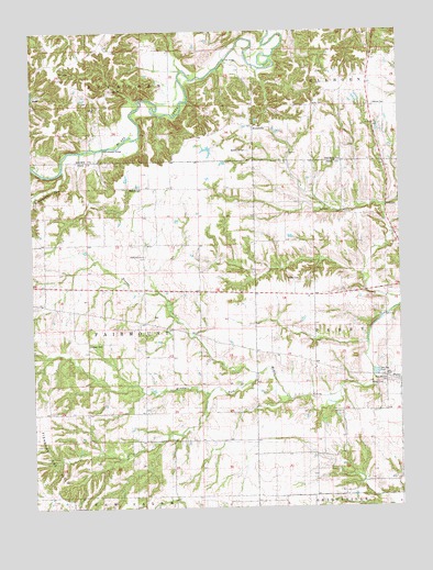
Perry West, IL USGS Topographic Map
Click on map above to begin viewing in our Map Viewer.

This topographic map contains these locations and features:
Feature Name Type Latitude Longitude GNIS ID View Map
BenvillePopulated PlaceN39.8642°W90.8649°422459View Map
Benville CemeteryCemeteryN39.8662°W90.8635°1821618View Map
Bottom Prairie School (historical)SchoolN39.8639°W90.8276°1720759View Map
Bower CreekStreamN39.7850°W90.7993°404732View Map
Bower School (historical)SchoolN39.7970°W90.8257°404736View Map
Brower CemeteryCemeteryN39.7931°W90.8562°1747223View Map
Dexter School (historical)SchoolN39.7920°W90.7793°407174View Map
Dixon PondReservoirN39.8492°W90.7571°1691575View Map
Dixon Pond DamDamN39.8484°W90.7568°1691574View Map
Fairmount ChurchChurchN39.8159°W90.8376°1747236View Map
Gardner School (historical)SchoolN39.8184°W90.8710°408888View Map
Grimes School (historical)SchoolN39.8253°W90.7621°409510View Map
Grove School (historical)SchoolN39.8637°W90.7607°409544View Map
Hebron CemeteryCemeteryN39.8556°W90.7590°1720783View Map
Hebron Church (historical)ChurchN39.8559°W90.7604°410015View Map
Hopewell School (historical)SchoolN39.7678°W90.8371°410526View Map
Lutz CemeteryCemeteryN39.8287°W90.7540°1747249View Map
MorrelvillePopulated PlaceN39.8503°W90.8004°423000View Map
Morrelville CemeteryCemeteryN39.8437°W90.8015°1720806View Map
Mountain AirportAirportN39.7770°W90.7508°2679106View Map
Perry-McCord CemeteryCemeteryN39.7820°W90.7546°1994497View Map
Rattlesnake Den CreekStreamN39.8387°W90.8646°416406View Map
Rush School (historical)SchoolN39.7678°W90.7999°417055View Map
Seaborn CemeteryCemeteryN39.8339°W90.8421°1747259View Map
Shadydale School (historical)SchoolN39.7525°W90.7807°1747261View Map
Shinnebarger BridgeBridgeN39.8445°W90.8507°425484View Map
South Prairie School (historical)SchoolN39.8195°W90.8329°1747264View Map
Stoner CemeteryCemeteryN39.8550°W90.7790°1720822View Map
Taylor CemeteryCemeteryN39.8100°W90.7885°1747269View Map
Test BridgeBridgeN39.8675°W90.8093°425551View Map
Township of FairmountCivilN39.7976°W90.8578°428987View Map
Wilson - Perry McCord CemeteryCemeteryN39.7828°W90.7546°1747253View Map
Wilson CemeteryCemeteryN39.7820°W90.7560°1747276View Map
Wilson FordCrossingN39.8395°W90.8646°423318View Map
Zion ChurchChurchN39.8506°W90.7585°1720833View Map
Zion Lutheran CemeteryCemeteryN39.8506°W90.7582°1821624View Map

Note: Coordinates in the location and feature list above are referenced to NAD83 datum.


Copyright (C) 2008-2025 Ryan Niemi / Sunset Dynamics ... All Rights Reserved