TopoQuest Logo
Do you find TopoQuest useful?
Help keep TopoQuest running and adding new maps/features by donating!
Bitcoin:  19c7KJd3qBynnjoSw5npx9KScwjBe4ifkT
Litecoin:  LXs6TkuXGGXo1vDsWCkWVdjQX94eUKd6ui
Home View Maps Find Maps Find Places Resources & Links


Mount Sterling, Illinois Topographic Map

USGS Map Title: Mount Sterling, IL
USGS Map MRC: 39090H7
DRG (GeoTIFF) Download: o39090h7.tif


Neighboring USGS Topographic Map Quads:


  Clayton, IL  
40090A8
 

  Lake Mount Sterling, IL  
40090A7
 

  Ripley, IL  
40090A6
 

  Kellerville, IL  
39090H8
 

  Mount Sterling, IL  
39090H7
 

  Versailles, IL  
39090H6
 

  Fishhook, IL  
39090G8
 

  Perry West, IL  
39090G7
 

  Perry East, IL  
39090G6


Map MRC Location:

N40°
W91°
N40°
W90°
H8 H7 H6 H5 H4 H3 H2 H1
G8 G7 G6 G5 G4 G3 G2 G1
F8 F7 F6 F5 F4 F3 F2 F1
E8 E7 E6 E5 E4 E3 E2 E1
D8 D7 D6 D5 D4 D3 D2 D1
C8 C7 C6 C5 C4 C3 C2 C1
B8 B7 B6 B5 B4 B3 B2 B1
A8 A7 A6 A5 A4 A3 A2 A1
N39°
W91°
N39°
W90°

Mount Sterling, IL USGS 1:24K Topographic Map Preview:
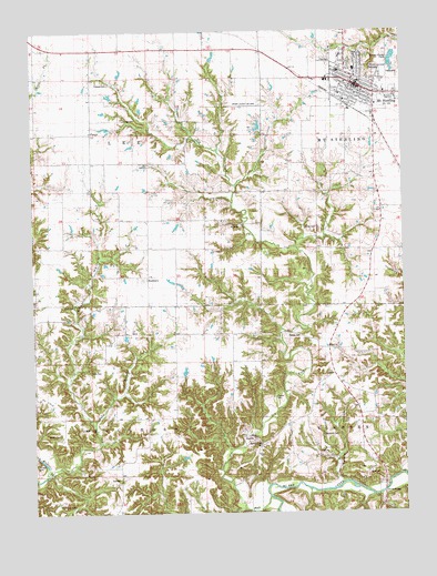
Mount Sterling, IL USGS Topographic Map
Click on map above to begin viewing in our Map Viewer.

This topographic map contains these locations and features:
Feature Name Type Latitude Longitude GNIS ID View Map
Brown CountyCivilN39.9618°W90.7503°424206View Map
Brown County Ambulance ServiceBuildingN39.9881°W90.7764°2673847View Map
Brown County Fire Protection DistrictBuildingN39.9881°W90.7766°2640923View Map
Brown County High SchoolSchoolN39.9825°W90.7526°1720761View Map
Brown County Sheriff's OfficeBuildingN39.9866°W90.7642°2758918View Map
BuckhornPopulated PlaceN39.9367°W90.8360°422510View Map
Buckhorn CemeteryCemeteryN39.9356°W90.8382°1821619View Map
Buckhorn School (historical)SchoolN39.9362°W90.8265°1720763View Map
Buckhorn TownhallBuildingN39.8839°W90.8468°1720762View Map
Butler CemeteryCemeteryN39.8956°W90.8665°1720764View Map
City of Mount SterlingCivilN39.9854°W90.7641°2395125View Map
Clark School (historical)SchoolN39.9812°W90.7976°1720767View Map
Cleaves CemeteryCemeteryN39.9864°W90.8490°1720769View Map
Cronin HollowValleyN39.8850°W90.8704°406796View Map
Dale School (historical)SchoolN39.8953°W90.8271°1720772View Map
Dearborn CemeteryCemeteryN39.8950°W90.7782°1720773View Map
DeHart CemeteryCemeteryN39.8881°W90.8746°1821620View Map
Dobey CemeteryCemeteryN39.9117°W90.8562°1720775View Map
Doby BranchStreamN39.8975°W90.8546°407268View Map
Dry ForkStreamN39.8789°W90.7960°407420View Map
FargoPopulated PlaceN39.9737°W90.8549°422690View Map
Fargo CemeteryCemeteryN39.9773°W90.8446°1720776View Map
Gerrish BridgeBridgeN39.8803°W90.7574°424914View Map
Holy Family Catholic ChurchChurchN39.9895°W90.7715°2040032View Map
Johnson School (historical)SchoolN39.9067°W90.7807°411174View Map
Keifer CemeteryCemeteryN39.9489°W90.7793°1720788View Map
Lester School (historical)SchoolN39.9953°W90.8262°1720793View Map
Linn CemeteryCemeteryN39.9289°W90.8651°1720794View Map
Lynn School (historical)SchoolN39.9067°W90.8740°412769View Map
Marden CemeteryCemeteryN39.8928°W90.7987°1720799View Map
Moore School (historical)SchoolN39.9192°W90.8276°1720805View Map
Mount SterlingPopulated PlaceN39.9873°W90.7635°414082View Map
Mount Sterling Catholic CemeteryCemeteryN39.9925°W90.7760°1821621View Map
Mount Sterling City CemeteryCemeteryN39.9898°W90.7587°1821622View Map
Mount Sterling Commercial Historic DistrictParkN39.9853°W90.7651°2040034View Map
Mount Sterling Fire DepartmentBuildingN39.9881°W90.7768°2640375View Map
Mount Sterling Municipal AirportAirportN39.9892°W90.8016°427581View Map
Mount Sterling Police DepartmentBuildingN39.9863°W90.7664°2759088View Map
Mount Sterling Post OfficePost OfficeN39.9858°W90.7662°2788913View Map
Mount Sterling Public LibraryBuildingN39.9856°W90.7640°2040035View Map
Mount Sterling QuarryMineN39.8937°W90.8029°1837335View Map
New School (historical)SchoolN39.9509°W90.8310°414466View Map
North Grade SchoolSchoolN39.9898°W90.7660°2040036View Map
Reeves CemeteryCemeteryN39.9212°W90.7890°1720815View Map
Sarrah HollowValleyN39.8833°W90.7728°418024View Map
Township of BuckhornCivilN39.8854°W90.8576°428729View Map
Township of LeeCivilN39.9735°W90.8560°429239View Map
Tucker CemeteryCemeteryN39.9048°W90.7937°1720825View Map
Two Rivers CampLocaleN39.8781°W90.8668°1720826View Map
Western Illinois Correctional CenterBuildingN39.9628°W90.7517°2740108View Map
White Oak Springs (historical)Populated PlaceN39.8834°W90.8174°2040043View Map
Whiteoak School (historical)SchoolN39.9514°W90.7793°1720830View Map

Note: Coordinates in the location and feature list above are referenced to NAD83 datum.


Copyright (C) 2008-2025 Ryan Niemi / Sunset Dynamics ... All Rights Reserved