TopoQuest Logo
Do you find TopoQuest useful?
Help keep TopoQuest running and adding new maps/features by donating!
Bitcoin:  19c7KJd3qBynnjoSw5npx9KScwjBe4ifkT
Litecoin:  LXs6TkuXGGXo1vDsWCkWVdjQX94eUKd6ui
Home View Maps Find Maps Find Places Resources & Links


Vesuvius, Virginia Topographic Map

USGS Map Title: Vesuvius, VA
USGS Map MRC: 37079H2
DRG (GeoTIFF) Download: o37079h2.tif


Neighboring USGS Topographic Map Quads:


  Augusta Springs, VA  
38079A3
 

  Greenville, VA  
38079A2
 

  Stuarts Draft, VA  
38079A1
 

  Brownsburg, VA  
37079H3
 

  Vesuvius, VA  
37079H2
 

  Big Levels, VA  
37079H1
 

  Cornwall, VA  
37079G3
 

  Montebello, VA  
37079G2
 

  Massies Mill, VA  
37079G1


Map MRC Location:

N38°
W80°
N38°
W79°
H8 H7 H6 H5 H4 H3 H2 H1
G8 G7 G6 G5 G4 G3 G2 G1
F8 F7 F6 F5 F4 F3 F2 F1
E8 E7 E6 E5 E4 E3 E2 E1
D8 D7 D6 D5 D4 D3 D2 D1
C8 C7 C6 C5 C4 C3 C2 C1
B8 B7 B6 B5 B4 B3 B2 B1
A8 A7 A6 A5 A4 A3 A2 A1
N37°
W80°
N37°
W79°

Vesuvius, VA USGS 1:24K Topographic Map Preview:
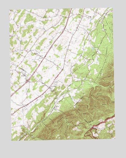
Vesuvius, VA USGS Topographic Map
Click on map above to begin viewing in our Map Viewer.

This topographic map contains these locations and features:
Feature Name Type Latitude Longitude GNIS ID View Map
Aggies MountainSummitN37.8776°W79.1684°1488591View Map
Anders Pond DamDamN37.9151°W79.1748°1489207View Map
Big Marys CreekStreamN37.8835°W79.2309°1481754View Map
Big Spy MountainSummitN37.9076°W79.1411°1499134View Map
Brook Hill Farm AirportAirportN37.9285°W79.1780°2675593View Map
Cellar HollowValleyN37.9282°W79.1463°1482419View Map
Cold SpringPopulated PlaceN37.9946°W79.1345°1499281View Map
Cold Springs Correctional Unit 10BuildingN37.9918°W79.1514°2767175View Map
Dogwood HollowValleyN37.9062°W79.1706°1483056View Map
Donald MountainSummitN37.9021°W79.1750°1779356View Map
Dutch Hollow Church (historical)ChurchN37.9918°W79.2398°1739602View Map
Emory ChurchChurchN37.9149°W79.1934°1483303View Map
Glenn FallsFallsN37.9185°W79.1948°1779362View Map
Gods TempleChurchN37.9915°W79.1623°1483684View Map
Groahs RidgeRidgeN37.9107°W79.1550°1483844View Map
Haines CemeteryCemeteryN37.8882°W79.1547°1805987View Map
Haines ChapelChurchN37.8885°W79.1545°1483887View Map
Interchange 205CrossingN37.9318°W79.2292°1779377View Map
Kiwanis LakeReservoirN37.9613°W79.1499°1489186View Map
Kiwanis Lake ParkParkN37.9626°W79.1478°1484624View Map
Koogler DamDamN37.9201°W79.2331°1490803View Map
Little Marys CreekStreamN37.9043°W79.2017°1484927View Map
Little Spy MountainSummitN37.9174°W79.1464°1484979View Map
LoftonPopulated PlaceN37.9551°W79.1645°1499682View Map
Marl CreekStreamN37.9140°W79.1961°1485191View Map
Marl Hill ChurchChurchN37.9221°W79.1995°1485192View Map
Marlbrook ChurchChurchN37.8996°W79.2484°1485193View Map
Moores CreekStreamN37.8832°W79.2331°1485548View Map
Mount Carmel ChurchChurchN37.9296°W79.1975°1485579View Map
Mount Joy ChurchChurchN37.9340°W79.1598°1485597View Map
Narrow Passage School (historical)SchoolN37.8857°W79.1700°1806000View Map
North Fork Spy RunStreamN37.9132°W79.1498°1485903View Map
Old Providence ChurchChurchN37.9610°W79.2253°1485962View Map
Pines ChapelChurchN37.9785°W79.1328°1486241View Map
PkinLocaleN37.9243°W79.1689°1486283View Map
RaphinePopulated PlaceN37.9374°W79.2328°1486508View Map
Raphine Post OfficePost OfficeN37.9377°W79.2326°2766273View Map
Raphine Volunteer Fire DepartmentBuildingN37.9376°W79.2333°2075610View Map
Rock HollowValleyN37.8972°W79.2052°1486697View Map
Saint Marys RiverStreamN37.9287°W79.1748°1486874View Map
Saint Pauls ChurchChurchN37.9274°W79.2075°1486878View Map
South River Number Four DamDamN37.9635°W79.1498°1489185View Map
South River Number Three DamDamN37.9901°W79.1498°1489184View Map
SpottswoodPopulated PlaceN37.9551°W79.2136°1500140View Map
Spottswood SchoolSchoolN37.9576°W79.2167°1487442View Map
Spy RunStreamN37.9304°W79.1614°1487496View Map
State Prison Camp Number 10LocaleN37.9918°W79.1511°1491259View Map
Steeles TavernPopulated PlaceN37.9257°W79.2025°1500156View Map
Steels Tavern Post OfficePost OfficeN37.9252°W79.2025°2766502View Map
Stillhouse HollowValleyN37.8922°W79.2126°1487579View Map
Stony Hill CemeteryCemeteryN37.9026°W79.1911°1806015View Map
Turkey HollowValleyN37.8899°W79.1802°1488023View Map
Tye River GapGapN37.8862°W79.1517°1488049View Map
Tye River Gap Recreational AreaParkN37.8943°W79.1848°1779395View Map
VesuviusPopulated PlaceN37.9062°W79.1973°1488126View Map
Vesuvius ChurchChurchN37.9046°W79.1959°1488127View Map
Vesuvius Post OfficePost OfficeN37.9065°W79.1978°2766314View Map
Wilkie (historical)Populated PlaceN37.8854°W79.1598°1806022View Map
Willow LakeReservoirN37.9201°W79.2331°1490804View Map

Note: Coordinates in the location and feature list above are referenced to NAD83 datum.


Copyright (C) 2008-2024 Ryan Niemi / Sunset Dynamics ... All Rights Reserved