TopoQuest Logo
Do you find TopoQuest useful?
Help keep TopoQuest running and adding new maps/features by donating!
Bitcoin:  19c7KJd3qBynnjoSw5npx9KScwjBe4ifkT
Litecoin:  LXs6TkuXGGXo1vDsWCkWVdjQX94eUKd6ui
Home View Maps Find Maps Find Places Resources & Links


Vinegar Bend, Alabama Topographic Map

USGS Map Title: Vinegar Bend, AL
USGS Map MRC: 31088C3
DRG (GeoTIFF) Download: o31088c3.tif


Neighboring USGS Topographic Map Quads:


  State Line, MS  
31088D4
 

  Chatom, AL  
31088D3
 

  Rutan, AL  
31088D2
 

  Fruitdale, AL  
31088C4
 

  Vinegar Bend, AL  
31088C3
 

  Seaboard, AL  
31088C2
 

  Rounsaville, MS  
31088B4
 

  Deer Park, AL  
31088B3
 

  Sims Chapel, AL  
31088B2


Map MRC Location:

N32°
W89°
N32°
W88°
H8 H7 H6 H5 H4 H3 H2 H1
G8 G7 G6 G5 G4 G3 G2 G1
F8 F7 F6 F5 F4 F3 F2 F1
E8 E7 E6 E5 E4 E3 E2 E1
D8 D7 D6 D5 D4 D3 D2 D1
C8 C7 C6 C5 C4 C3 C2 C1
B8 B7 B6 B5 B4 B3 B2 B1
A8 A7 A6 A5 A4 A3 A2 A1
N31°
W89°
N31°
W88°

Vinegar Bend, AL USGS 1:24K Topographic Map Preview:
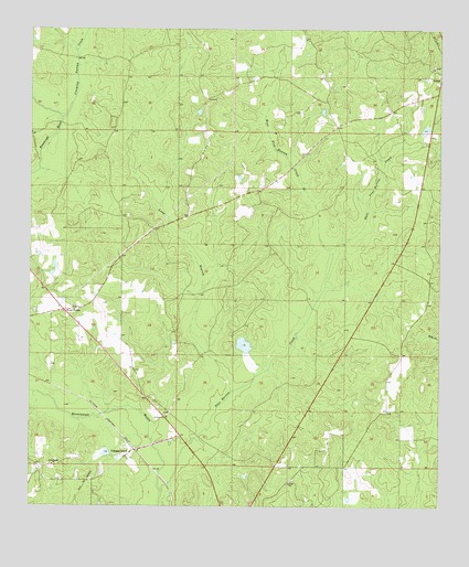
Vinegar Bend, AL USGS Topographic Map
Click on map above to begin viewing in our Map Viewer.

This topographic map contains these locations and features:
Feature Name Type Latitude Longitude GNIS ID View Map
Booker T Washington High School (historical)SchoolN31.2610°W88.3683°149545View Map
Creeping Swamp CreekStreamN31.3518°W88.3656°116843View Map
D R Stallworth DamDamN31.2635°W88.3517°129751View Map
D R Stallworth PondReservoirN31.2642°W88.3514°129750View Map
East Pine Barren CreekStreamN31.3166°W88.2828°117783View Map
Four PointPopulated PlaceN31.3013°W88.3645°118546View Map
Four Points Baptist ChurchChurchN31.3021°W88.3661°138898View Map
Four Points CemeteryCemeteryN31.3202°W88.3425°150045View Map
Fruitdale DivisionCivilN31.2694°W88.3184°165992View Map
Little Bethel Baptist ChurchChurchN31.2610°W88.3681°152083View Map
Long BranchStreamN31.2802°W88.3133°121984View Map
Parnell DamDamN31.3468°W88.2550°129778View Map
Parnells PondReservoirN31.3489°W88.2546°129779View Map
Pine Barren CreekStreamN31.2627°W88.3347°138796View Map
Pine BranchStreamN31.2541°W88.3345°124761View Map
Quovadis (historical)LocaleN31.2807°W88.3653°138803View Map
Saint Johns ChurchChurchN31.2735°W88.3331°150013View Map
Stallworth DamDamN31.2902°W88.3083°129763View Map
Stallworth LakeReservoirN31.2924°W88.3097°129762View Map
Tibbie Baptist ChurchChurchN31.3646°W88.2520°138835View Map
Tibbie CemeteryCemeteryN31.3654°W88.2522°157624View Map
Vinegar BendPopulated PlaceN31.2638°W88.3447°153854View Map
Vinegar Bend Census Designated PlaceCensusN31.2594°W88.3712°2628608View Map
Vinegar Bend Post OfficePost OfficeN31.2641°W88.3436°166978View Map
West Pine Barren CreekStreamN31.3166°W88.2825°128790View Map

Note: Coordinates in the location and feature list above are referenced to NAD83 datum.


Copyright (C) 2008-2024 Ryan Niemi / Sunset Dynamics ... All Rights Reserved