TopoQuest Logo
Do you find TopoQuest useful?
Help keep TopoQuest running and adding new maps/features by donating!
Bitcoin:  19c7KJd3qBynnjoSw5npx9KScwjBe4ifkT
Litecoin:  LXs6TkuXGGXo1vDsWCkWVdjQX94eUKd6ui
Home View Maps Find Maps Find Places Resources & Links


Viola, Arkansas Topographic Map

USGS Map Title: Viola, AR
USGS Map MRC: 36091D8
DRG (GeoTIFF) Download: o36091d8.tif


Neighboring USGS Topographic Map Quads:


  Caulfield, MO  
36092E1
 

  Moody, MO  
36091E8
 

  Lanton, MO  
36091E7
 

  Gepp, AR  
36092D1
 

  Viola, AR  
36091D8
 

  Salem Knob, AR  
36091D7
 

  Elizabeth, AR  
36092C1
 

  Byron, AR  
36091C8
 

  Salem, AR  
36091C7


Map MRC Location:

N37°
W92°
N37°
W91°
H8 H7 H6 H5 H4 H3 H2 H1
G8 G7 G6 G5 G4 G3 G2 G1
F8 F7 F6 F5 F4 F3 F2 F1
E8 E7 E6 E5 E4 E3 E2 E1
D8 D7 D6 D5 D4 D3 D2 D1
C8 C7 C6 C5 C4 C3 C2 C1
B8 B7 B6 B5 B4 B3 B2 B1
A8 A7 A6 A5 A4 A3 A2 A1
N36°
W92°
N36°
W91°

Viola, AR USGS 1:24K Topographic Map Preview:
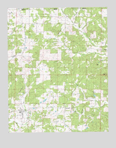
Viola, AR USGS Topographic Map
Click on map above to begin viewing in our Map Viewer.

This topographic map contains these locations and features:
Feature Name Type Latitude Longitude GNIS ID View Map
Barker CemeteryCemeteryN36.3842°W91.9910°63047View Map
Bay Creek ChurchChurchN36.4806°W91.9107°78478View Map
Davenport CreekStreamN36.4059°W91.8907°48366View Map
Flint SpringSpringN36.3984°W91.9211°49135View Map
Flint Spring ChurchChurchN36.3976°W91.9279°49136View Map
Flint SpringsPopulated PlaceN36.3998°W91.9290°63051View Map
Greasy BranchStreamN36.4545°W91.9132°49617View Map
Gum Spring CemeteryCemeteryN36.4062°W91.8865°49729View Map
Gum Spring ChurchChurchN36.4062°W91.8868°49730View Map
Hay HollowValleyN36.4822°W91.9165°49956View Map
James LakeReservoirN36.4034°W91.9402°79735View Map
James Lake Dam Number OneDamN36.4034°W91.9402°79734View Map
Lake LeonReservoirN36.3751°W91.9001°79733View Map
Lake Leon DamDamN36.3751°W91.9001°79732View Map
Liberty Hill School (historical)SchoolN36.4570°W91.8779°51121View Map
Mount Calm ChurchChurchN36.4517°W91.9940°81880View Map
Shaw KnobSummitN36.4426°W91.8938°58609View Map
Sparks LakeReservoirN36.3991°W91.9685°80970View Map
Sparks Lake DamDamN36.4001°W91.9702°80969View Map
Spring LakeReservoirN36.4167°W91.8951°79639View Map
Spring Lake DamDamN36.4167°W91.8951°79638View Map
Sturkie Volunteer Fire DepartmentBuildingN36.4568°W91.8786°2117179View Map
Town of ViolaCivilN36.3971°W91.9860°2406804View Map
Township of FultonCivilN36.3871°W91.9937°66576View Map
Township of Mount CalmCivilN36.4658°W91.9903°66578View Map
ViolaPopulated PlaceN36.3967°W91.9827°58806View Map
Viola CemeteryCemeteryN36.3931°W91.9743°76662View Map
Viola Elementary SchoolSchoolN36.3952°W91.9852°63065View Map
Viola High SchoolSchoolN36.3959°W91.9863°63066View Map
Viola Post OfficePost OfficeN36.3971°W91.9859°2781901View Map
Viola Volunteer Fire DepartmentBuildingN36.3935°W91.9826°2117257View Map
Watkins CemeteryCemeteryN36.4645°W91.8799°63067View Map
Wildcat KnobSummitN36.4326°W91.8779°56368View Map

Note: Coordinates in the location and feature list above are referenced to NAD83 datum.


Copyright (C) 2008-2025 Ryan Niemi / Sunset Dynamics ... All Rights Reserved