TopoQuest Logo
Do you find TopoQuest useful?
Help keep TopoQuest running and adding new maps/features by donating!
Bitcoin:  19c7KJd3qBynnjoSw5npx9KScwjBe4ifkT
Litecoin:  LXs6TkuXGGXo1vDsWCkWVdjQX94eUKd6ui
Home View Maps Find Maps Find Places Resources & Links


Lanton, Missouri Topographic Map

USGS Map Title: Lanton, MO
USGS Map MRC: 36091E7
DRG (GeoTIFF) Download: o36091e7.tif


Neighboring USGS Topographic Map Quads:


  South Fork, MO  
36091F8
 

  West Plains, MO  
36091F7
 

  Brandsville, MO  
36091F6
 

  Moody, MO  
36091E8
 

  Lanton, MO  
36091E7
 

  Koshkonong, MO  
36091E6
 

  Viola, AR  
36091D8
 

  Salem Knob, AR  
36091D7
 

  Camp, AR  
36091D6


Map MRC Location:

N37°
W92°
N37°
W91°
H8 H7 H6 H5 H4 H3 H2 H1
G8 G7 G6 G5 G4 G3 G2 G1
F8 F7 F6 F5 F4 F3 F2 F1
E8 E7 E6 E5 E4 E3 E2 E1
D8 D7 D6 D5 D4 D3 D2 D1
C8 C7 C6 C5 C4 C3 C2 C1
B8 B7 B6 B5 B4 B3 B2 B1
A8 A7 A6 A5 A4 A3 A2 A1
N36°
W92°
N36°
W91°

Lanton, MO USGS 1:24K Topographic Map Preview:
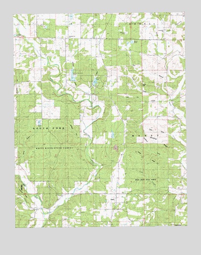
Lanton, MO USGS Topographic Map
Click on map above to begin viewing in our Map Viewer.

This topographic map contains these locations and features:
Feature Name Type Latitude Longitude GNIS ID View Map
Adobesee PondLakeN36.6132°W91.7932°713160View Map
Alter DamDamN36.5534°W91.8035°764478View Map
Ball BranchStreamN36.5745°W91.7601°713601View Map
Brent LakeReservoirN36.5849°W91.8162°758400View Map
Brent Lake DamDamN36.5834°W91.8168°764477View Map
Bunt SpringSpringN36.5598°W91.8551°715057View Map
Byler Lake DamDamN36.5601°W91.8568°764777View Map
Cannon GraveyardCemeteryN36.5048°W91.8524°735151View Map
Clyde Stewart LakeReservoirN36.5614°W91.8570°764778View Map
Devils DenBasinN36.5825°W91.7825°716860View Map
Dividing RidgeRidgeN36.5478°W91.7665°716920View Map
Doty School (historical)SchoolN36.5853°W91.8632°716997View Map
Elkhorn BranchStreamN36.5109°W91.8560°717464View Map
FruitvillePopulated PlaceN36.6162°W91.7654°735150View Map
Fruitville SchoolSchoolN36.5990°W91.7643°718269View Map
GlobePopulated PlaceN36.5628°W91.7551°740441View Map
Globe Post OfficePost OfficeN36.5628°W91.7551°760039View Map
Gordon BranchStreamN36.6176°W91.7679°718610View Map
Hatfield SchoolSchoolN36.5298°W91.7535°719205View Map
Hay HollowValleyN36.5812°W91.8199°719250View Map
Highland Park ChurchChurchN36.5142°W91.8021°735149View Map
Hopewell SchoolSchoolN36.5240°W91.8504°719812View Map
House HollowValleyN36.5540°W91.7601°719891View Map
Hunt BranchStreamN36.5195°W91.7554°720000View Map
LantonPopulated PlaceN36.5173°W91.8015°720814View Map
Lanton School (historical)SchoolN36.5187°W91.8015°735148View Map
Lanton Volunteer Fire DepartmentBuildingN36.5170°W91.8014°2621549View Map
Leo (historical)LocaleN36.5992°W91.8357°740442View Map
Leo Post OfficePost OfficeN36.5992°W91.8357°760042View Map
Lime Kiln HollowValleyN36.5720°W91.7635°721066View Map
Matne HollowValleyN36.5378°W91.8740°721975View Map
McGinty HollowValleyN36.5809°W91.8263°722114View Map
Meltabarger CemeteryCemeteryN36.6137°W91.7660°722209View Map
Meredith HollowValleyN36.5178°W91.7654°735147View Map
Middle RidgeRidgeN36.5390°W91.7793°722288View Map
Mott (historical)Populated PlaceN36.5753°W91.8051°735146View Map
Mott School (historical)SchoolN36.5778°W91.8185°722686View Map
Myatt PondLakeN36.6080°W91.7887°723094View Map
Stace Shannon Lake DamDamN36.5851°W91.8318°765064View Map
Stace-Shannon LakeReservoirN36.5886°W91.8323°738501View Map
Stuart HollowValleyN36.5740°W91.7688°727192View Map
Sycamore HollowValleyN36.5392°W91.7551°727413View Map
Tingler LakeLakeN36.6127°W91.8736°727672View Map
Township Line ChurchChurchN36.6115°W91.8338°742075View Map
Township Line SchoolSchoolN36.6115°W91.8338°727746View Map
West Fork Spring CreekStreamN36.5081°W91.8538°728579View Map
White River State ForestForestN36.5440°W91.8407°743071View Map
Wilson HollowValleyN36.5551°W91.8246°728971View Map

Note: Coordinates in the location and feature list above are referenced to NAD83 datum.


Copyright (C) 2008-2025 Ryan Niemi / Sunset Dynamics ... All Rights Reserved