TopoQuest Logo
Do you find TopoQuest useful?
Help keep TopoQuest running and adding new maps/features by donating!
Bitcoin:  19c7KJd3qBynnjoSw5npx9KScwjBe4ifkT
Litecoin:  LXs6TkuXGGXo1vDsWCkWVdjQX94eUKd6ui
Home View Maps Find Maps Find Places Resources & Links


Virden South, Illinois Topographic Map

USGS Map Title: Virden South, IL
USGS Map MRC: 39089D7
DRG (GeoTIFF) Download: o39089d7.tif


Neighboring USGS Topographic Map Quads:


  Waverly, IL  
39089E8
 

  Virden North, IL  
39089E7
 

  Divernon, IL  
39089E6
 

  Palmyra, IL  
39089D8
 

  Virden South, IL  
39089D7
 

  Farmersville, IL  
39089D6
 

  Carlinville West, IL  
39089C8
 

  Carlinville East, IL  
39089C7
 

  Atwater, IL  
39089C6


Map MRC Location:

N40°
W90°
N40°
W89°
H8 H7 H6 H5 H4 H3 H2 H1
G8 G7 G6 G5 G4 G3 G2 G1
F8 F7 F6 F5 F4 F3 F2 F1
E8 E7 E6 E5 E4 E3 E2 E1
D8 D7 D6 D5 D4 D3 D2 D1
C8 C7 C6 C5 C4 C3 C2 C1
B8 B7 B6 B5 B4 B3 B2 B1
A8 A7 A6 A5 A4 A3 A2 A1
N39°
W90°
N39°
W89°

Virden South, IL USGS 1:24K Topographic Map Preview:
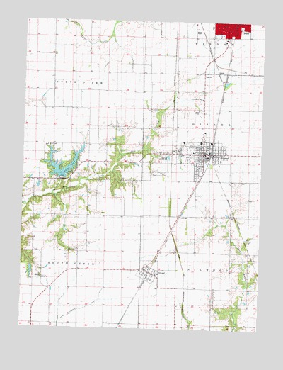
Virden South, IL USGS Topographic Map
Click on map above to begin viewing in our Map Viewer.

This topographic map contains these locations and features:
Feature Name Type Latitude Longitude GNIS ID View Map
Cherry Grove School (historical)SchoolN39.4164°W89.7651°1764595View Map
City of GirardCivilN39.4466°W89.7820°2394904View Map
East Public School (historical)SchoolN39.4981°W89.7626°1962259View Map
First Baptist ChurchChurchN39.4456°W89.7809°1962261View Map
First Methodist Episcopal ChurchChurchN39.4995°W89.7704°1962263View Map
Franklin School (historical)SchoolN39.4570°W89.8648°1764619View Map
GirardPopulated PlaceN39.4464°W89.7809°409041View Map
Girard CemeteryCemeteryN39.4475°W89.7915°1994446View Map
Girard City CemeteryCemeteryN39.4464°W89.7923°2009768View Map
Girard Fire Protection DistrictBuildingN39.4471°W89.7778°2640210View Map
Girard Fire Protection DistrictBuildingN39.3989°W89.8076°2640735View Map
Girard High SchoolSchoolN39.4509°W89.7818°1821343View Map
Girard Post OfficePost OfficeN39.4456°W89.7795°2788394View Map
Girard Sunset LakeReservoirN39.4351°W89.8484°1691929View Map
Girard Sunset Lake DamDamN39.4351°W89.8484°1691928View Map
GreenridgePopulated PlaceN39.4195°W89.7945°422758View Map
Hazel Green School (historical)SchoolN39.4203°W89.8362°1764626View Map
Hickory Point School (historical)SchoolN39.3917°W89.8557°1764630View Map
Hulcher RLA Airport (historical)AirportN39.4959°W89.7857°427890View Map
Lynchburg School (historical)SchoolN39.4428°W89.8123°1764648View Map
New House of Prayer ChurchChurchN39.4687°W89.7818°414436View Map
NilwoodPopulated PlaceN39.3981°W89.8087°414526View Map
Nilwood Post OfficePost OfficeN39.3981°W89.8087°2788595View Map
Oak Leaf Country ClubLocaleN39.4445°W89.7995°425259View Map
Pleasant Hill CemeteryCemeteryN39.4798°W89.7965°415821View Map
Pleasant Hill School (historical)SchoolN39.4720°W89.7948°1764679View Map
Prairieland Community Ambulance ServiceBuildingN39.4979°W89.7683°2673841View Map
Ross CemeteryCemeteryN39.4064°W89.8501°416972View Map
South Otter TownhallBuildingN39.3953°W89.8645°1764704View Map
Sugar Creek School (historical)SchoolN39.4914°W89.8418°1764711View Map
Sunset LakeReservoirN39.4365°W89.8536°419412View Map
Town of NilwoodCivilN39.3995°W89.8077°2396817View Map
Township of GirardCivilN39.4575°W89.7567°429054View Map
Township of NilwoodCivilN39.3917°W89.7560°429448View Map
Township of North OtterCivilN39.4788°W89.8693°429463View Map
Township of South OtterCivilN39.3914°W89.8686°429775View Map
Trinity Lutheran ChurchChurchN39.4784°W89.7804°419861View Map
Union ChapelChurchN39.4492°W89.8620°420041View Map
Union Chapel CemeteryCemeteryN39.4492°W89.8623°2005935View Map
United Methodist Church of GirardChurchN39.4462°W89.7820°1962269View Map
Whites PondReservoirN39.3982°W89.8701°1692219View Map
Whites Pond DamDamN39.4000°W89.8701°1692218View Map

Note: Coordinates in the location and feature list above are referenced to NAD83 datum.


Copyright (C) 2008-2025 Ryan Niemi / Sunset Dynamics ... All Rights Reserved