TopoQuest Logo
Do you find TopoQuest useful?
Help keep TopoQuest running and adding new maps/features by donating!
Bitcoin:  19c7KJd3qBynnjoSw5npx9KScwjBe4ifkT
Litecoin:  LXs6TkuXGGXo1vDsWCkWVdjQX94eUKd6ui
Home View Maps Find Maps Find Places Resources & Links


Wahoo Ranch, New Mexico Topographic Map

USGS Map Title: Wahoo Ranch, NM
USGS Map MRC: 33107E6
DRG (GeoTIFF) Download: o33107e6.tif


Neighboring USGS Topographic Map Quads:


  Paddys Hole, NM  
33107F7
 

  Dusty, NM  
33107F6
 

  Welty Hill, NM  
33107F5
 

  Wahoo Peak, NM  
33107E7
 

  Wahoo Ranch, NM  
33107E6
 

  Montoya Butte, NM  
33107E5
 

  Sawmill Peak, NM  
33107D7
 

  Iron Mountain, NM  
33107D6
 

  Jaralosa Mountain, NM  
33107D5


Map MRC Location:

N34°
W108°
N34°
W107°
H8 H7 H6 H5 H4 H3 H2 H1
G8 G7 G6 G5 G4 G3 G2 G1
F8 F7 F6 F5 F4 F3 F2 F1
E8 E7 E6 E5 E4 E3 E2 E1
D8 D7 D6 D5 D4 D3 D2 D1
C8 C7 C6 C5 C4 C3 C2 C1
B8 B7 B6 B5 B4 B3 B2 B1
A8 A7 A6 A5 A4 A3 A2 A1
N33°
W108°
N33°
W107°

Wahoo Ranch, NM USGS 1:24K Topographic Map Preview:
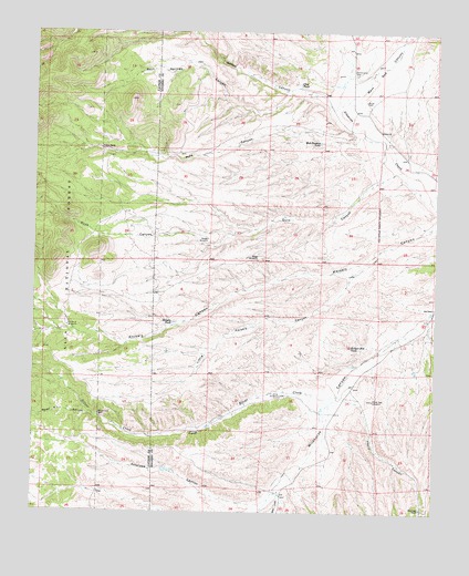
Wahoo Ranch, NM USGS Topographic Map
Click on map above to begin viewing in our Map Viewer.

This topographic map contains these locations and features:
Feature Name Type Latitude Longitude GNIS ID View Map
Antelope CanyonValleyN33.5034°W107.6767°903182View Map
Badger Hole TankReservoirN33.5433°W107.6519°903492View Map
Badger WindmillLocaleN33.5712°W107.6962°903494View Map
Badger Windmill Water WellWellN33.5712°W107.6967°922014View Map
Bull Pasture TankReservoirN33.5964°W107.6624°904186View Map
Clay TankReservoirN33.6118°W107.6686°905192View Map
Cox RanchLocaleN33.5537°W107.6259°905464View Map
Duck CanyonValleyN33.5895°W107.6367°905894View Map
Dusty (historical)Populated PlaceN33.6123°W107.6517°920137View Map
Dusty CemeteryCemeteryN33.6073°W107.6478°905915View Map
Dusty Post Office (historical)Post OfficeN33.6123°W107.6517°938346View Map
Folsby Water WellWellN33.5053°W107.6734°922004View Map
H Over H Water WellWellN33.5484°W107.7398°919636View Map
H-over-H WindmillLocaleN33.5481°W107.7400°906801View Map
Havill CanyonValleyN33.5306°W107.6556°906874View Map
Headquaters Water WellWellN33.5537°W107.6259°922010View Map
Hipp CreekStreamN33.5042°W107.6737°906991View Map
Hutchison RanchLocaleN33.5015°W107.6292°907173View Map
KniselyArroyoN33.5470°W107.7406°929663View Map
Knisely TankReservoirN33.5493°W107.7073°907580View Map
Knisely Water WellWellN33.5537°W107.6800°922009View Map
Lighting Water WellWellN33.5212°W107.6987°922008View Map
Lightning WindmillLocaleN33.5212°W107.6984°907957View Map
Little Knisely CanyonValleyN33.5684°W107.6428°908030View Map
Little Knisley CanyonArroyoN33.5328°W107.7056°929537View Map
Pole CanyonValleyN33.5981°W107.6487°909767View Map
Ridge WindmillLocaleN33.5656°W107.6809°910168View Map
Ridge Windmill Water WellWellN33.5656°W107.6809°925758View Map
Rock Spring Water WellWellN33.6173°W107.7014°925599View Map
Rock Springs CanyonValleyN33.6101°W107.6714°910383View Map
Seven H L CanyonValleyN33.5253°W107.7328°910957View Map
Silver CreekStreamN33.5306°W107.6556°911065View Map
Silver WindmillLocaleN33.5303°W107.6734°1847399View Map
Silver Windmill Water WellWellN33.5306°W107.6739°925798View Map
Uncle Sam WellWellN33.5253°W107.7298°911953View Map
Wahoo CanyonValleyN33.6048°W107.6559°912131View Map
Wahoo RanchLocaleN33.5945°W107.7300°912132View Map
West Red CanyonValleyN33.6062°W107.6559°912255View Map
Windy Gap Water WellWellN33.5295°W107.6464°925797View Map
Windy Gap WindmillLocaleN33.5292°W107.6448°912462View Map

Note: Coordinates in the location and feature list above are referenced to NAD83 datum.


Copyright (C) 2008-2025 Ryan Niemi / Sunset Dynamics ... All Rights Reserved