TopoQuest Logo
Do you find TopoQuest useful?
Help keep TopoQuest running and adding new maps/features by donating!
Bitcoin:  19c7KJd3qBynnjoSw5npx9KScwjBe4ifkT
Litecoin:  LXs6TkuXGGXo1vDsWCkWVdjQX94eUKd6ui
Home View Maps Find Maps Find Places Resources & Links


Wakefield, Texas Topographic Map

USGS Map Title: Wakefield, TX
USGS Map MRC: 31094A7
DRG (GeoTIFF) Download: o31094a7.tif


Neighboring USGS Topographic Map Quads:


  Apple Springs, TX  
31094B8
 

  Diboll, TX  
31094B7
 

  Bald Hill, TX  
31094B6
 

  Trevat, TX  
31094A8
 

  Wakefield, TX  
31094A7
 

  Pluck, TX  
31094A6
 

  Carmona, TX  
30094H8
 

  Corrigan, TX  
30094H7
 

  Camden, TX  
30094H6


Map MRC Location:

N32°
W95°
N32°
W94°
H8 H7 H6 H5 H4 H3 H2 H1
G8 G7 G6 G5 G4 G3 G2 G1
F8 F7 F6 F5 F4 F3 F2 F1
E8 E7 E6 E5 E4 E3 E2 E1
D8 D7 D6 D5 D4 D3 D2 D1
C8 C7 C6 C5 C4 C3 C2 C1
B8 B7 B6 B5 B4 B3 B2 B1
A8 A7 A6 A5 A4 A3 A2 A1
N31°
W95°
N31°
W94°

Wakefield, TX USGS 1:24K Topographic Map Preview:
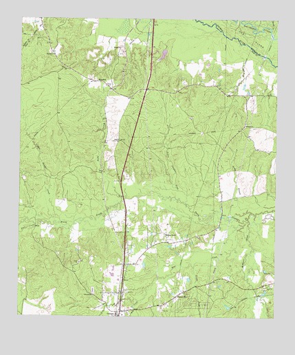
Wakefield, TX USGS Topographic Map
Click on map above to begin viewing in our Map Viewer.

This topographic map contains these locations and features:
Feature Name Type Latitude Longitude GNIS ID View Map
Anderosa AirparkAirportN31.0451°W94.8527°2675934View Map
Bear CreekStreamN31.0399°W94.7655°1351678View Map
Cold Spring ChurchChurchN31.0088°W94.8385°1354750View Map
Corrigan DivisionCivilN31.0000°W94.8139°1938650View Map
Corrigan Fire DepartmentBuildingN31.0130°W94.8250°2655271View Map
Corrigan Post OfficePost OfficeN31.0019°W94.8250°2731139View Map
Creeds CreekStreamN31.0216°W94.7894°1355339View Map
Damascus ChurchChurchN31.0807°W94.7649°1355608View Map
Dollarhide CutoffGutN31.1205°W94.7591°1356141View Map
Dry CreekStreamN31.0066°W94.8163°1356323View Map
Knox CemeteryCemeteryN31.0027°W94.8047°1360733View Map
Lower Sulphur CreekStreamN31.0477°W94.7935°1361929View Map
McManus CreekStreamN31.0405°W94.7630°1362509View Map
Paces CreekStreamN31.0380°W94.8677°1375323View Map
Pleasant HillPopulated PlaceN31.0088°W94.7977°1365422View Map
Pleasant Hill Census Designated PlaceCensusN31.0033°W94.7936°2586972View Map
Rocky CreekStreamN31.0502°W94.8247°1366762View Map
Sandy BranchStreamN31.0435°W94.7608°1367690View Map
Skinner TownPopulated PlaceN31.0349°W94.8035°1380552View Map
Stovall CreekStreamN31.1213°W94.7535°1383767View Map
Stovall CreekStreamN31.1219°W94.7533°1376315View Map
Stryker CemeteryCemeteryN31.0191°W94.7513°1369294View Map
The IslandIslandN31.1216°W94.7727°1383769View Map
The IslandIslandN31.1135°W94.7563°1369787View Map
Upper Sulphur CreekStreamN31.0388°W94.8544°1370525View Map
WakefieldPopulated PlaceN31.0988°W94.8352°1380731View Map
Wakefield ChurchChurchN31.1099°W94.8591°1370740View Map
Wakefield Lookout TowerTowerN31.0738°W94.8260°1384706View Map
Wheeler ChurchChurchN31.1130°W94.8260°1371332View Map

Note: Coordinates in the location and feature list above are referenced to NAD83 datum.


Copyright (C) 2008-2024 Ryan Niemi / Sunset Dynamics ... All Rights Reserved