TopoQuest Logo
Do you find TopoQuest useful?
Help keep TopoQuest running and adding new maps/features by donating!
Bitcoin:  19c7KJd3qBynnjoSw5npx9KScwjBe4ifkT
Litecoin:  LXs6TkuXGGXo1vDsWCkWVdjQX94eUKd6ui
Home View Maps Find Maps Find Places Resources & Links


Lucasville, Ohio Topographic Map

USGS Map Title: Lucasville, OH
USGS Map MRC: 38082H8
DRG (GeoTIFF) Download: o38082h8.tif


Neighboring USGS Topographic Map Quads:


  Piketon, OH  
39083A1
 

  Waverly South, OH  
39082A8
 

  Beaver, OH  
39082A7
 

  Wakefield, OH  
38083H1
 

  Lucasville, OH  
38082H8
 

  Stockdale, OH  
38082H7
 

  West Portsmouth, OH  
38083G1
 

  New Boston, OH  
38082G8
 

  Minford, OH  
38082G7


Map MRC Location:

N39°
W83°
N39°
W82°
H8 H7 H6 H5 H4 H3 H2 H1
G8 G7 G6 G5 G4 G3 G2 G1
F8 F7 F6 F5 F4 F3 F2 F1
E8 E7 E6 E5 E4 E3 E2 E1
D8 D7 D6 D5 D4 D3 D2 D1
C8 C7 C6 C5 C4 C3 C2 C1
B8 B7 B6 B5 B4 B3 B2 B1
A8 A7 A6 A5 A4 A3 A2 A1
N38°
W83°
N38°
W82°

Lucasville, OH USGS 1:24K Topographic Map Preview:
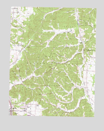
Lucasville, OH USGS Topographic Map
Click on map above to begin viewing in our Map Viewer.

This topographic map contains these locations and features:
Feature Name Type Latitude Longitude GNIS ID View Map
Adams CemeteryCemeteryN38.9429°W82.8780°1037312View Map
Adams School (historical)SchoolN38.9354°W82.8857°1049470View Map
Andrew HollowValleyN38.9815°W82.8988°1037422View Map
Back RunStreamN38.9081°W82.8916°1060839View Map
Bailey ChapelChurchN38.9934°W82.9905°1037573View Map
Bailey Chapel CemeteryCemeteryN38.9945°W82.9907°1963393View Map
Barker HollowValleyN38.9198°W82.9749°1037635View Map
Bennett CemeteryCemeteryN38.8998°W82.8843°1037855View Map
Blue RunStreamN38.8965°W82.8877°1066371View Map
Blue Run CemeteryCemeteryN38.8853°W82.9149°1964228View Map
Blue Run ChurchChurchN38.8795°W82.9143°1038148View Map
Blue Run School (historical)SchoolN38.8823°W82.9188°1049474View Map
Brigner HollowValleyN38.9959°W82.9057°1038316View Map
Buck RunStreamN38.9029°W82.9080°1066373View Map
Bull RunStreamN38.9206°W82.8755°1038513View Map
Canter CemeteryCemeteryN38.9485°W82.9003°1038802View Map
Cockrell RunPopulated PlaceN38.9534°W82.9791°1039214View Map
Cockrell RunStreamN38.9117°W82.9916°1060982View Map
Cockrell School (historical)SchoolN38.9451°W82.9882°1049475View Map
Cook HollowValleyN38.9067°W82.9738°1039333View Map
Coon HollowValleyN38.9229°W82.9655°1039345View Map
County Line Siding (historical)LocaleN38.9454°W82.8927°1049469View Map
Dace HollowValleyN38.9145°W82.9832°1039556View Map
Diffen HillSummitN38.9312°W82.9382°1056258View Map
Fairview ChurchChurchN38.9059°W82.8857°1040344View Map
Fairview School (historical)SchoolN38.9056°W82.8860°1049471View Map
Fallen Timber ChurchChurchN38.9354°W82.9310°1040374View Map
Fallen Timber CreekStreamN38.9492°W82.8935°1040375View Map
Fallen Timber School (historical)SchoolN38.9359°W82.9313°1049472View Map
Gee CemeteryCemeteryN38.9669°W82.9036°1040806View Map
Gravel HillSummitN38.9767°W82.8780°1056301View Map
Gravel Hill CemeteryCemeteryN38.9801°W82.8818°1041079View Map
Hall CemeteryCemeteryN38.9637°W82.9127°1041246View Map
Harger CemeteryCemeteryN38.9092°W82.9427°1041319View Map
Haskind CemeteryCemeteryN38.9918°W82.9733°1041389View Map
Haystack KnobSummitN38.8773°W82.9910°1056320View Map
Hockenberry HollowValleyN38.9117°W82.9810°1049476View Map
Hockenberry HollowStreamN38.9131°W82.9841°1037566View Map
Hog HollowValleyN38.9117°W82.9041°1041648View Map
Howard CemeteryCemeteryN38.9931°W82.9957°1963406View Map
Howards HollowValleyN38.8826°W82.9238°1041834View Map
Hunting RunStreamN38.9590°W82.8941°1063461View Map
Jacobs CemeteryCemeteryN38.9356°W82.9379°1042042View Map
Koger HollowValleyN38.9595°W82.8913°1042337View Map
LucasvillePopulated PlaceN38.8795°W82.9968°1061449View Map
Lucasville Census Designated PlaceCensusN38.8783°W82.9934°2393112View Map
Lucasville Post OfficePost OfficeN38.8792°W82.9971°2044068View Map
Luckett CemeteryCemeteryN38.9249°W82.9930°1042823View Map
Luckett HollowValleyN38.9195°W82.9860°1042824View Map
Madison ChurchChurchN38.9720°W82.9157°1042879View Map
Martin CemeteryCemeteryN38.9140°W82.8863°1043022View Map
Miller Run ChurchChurchN38.9137°W82.9810°1043371View Map
Miller Run School (historical)SchoolN38.9134°W82.9818°1049477View Map
Musgrave HollowValleyN38.9862°W82.8993°1043744View Map
Nail HollowValleyN38.9087°W82.9788°1043771View Map
New Scioto CemeteryCemeteryN38.9490°W82.9854°1964235View Map
Old Lucasville CemeteryCemeteryN38.8790°W82.9982°1964236View Map
Owl CreekStreamN38.9620°W82.8974°1044252View Map
Owl Creek CemeteryCemeteryN38.9731°W82.9106°1044259View Map
Owl Creek ChurchChurchN38.9673°W82.8968°1044260View Map
Pine Grove ChurchChurchN38.9092°W82.9435°1044459View Map
Preston AdditionPopulated PlaceN38.8881°W82.9607°1056481View Map
Pyle CemeteryCemeteryN38.9098°W82.9063°1044804View Map
Pyle HollowValleyN38.8806°W82.9174°1044805View Map
Rose HillSummitN38.8998°W82.9518°1056494View Map
Sand RunStreamN38.9592°W82.8935°1045935View Map
Scioto Ambulance District Squad 5BuildingN38.8789°W82.9984°2550893View Map
Scioto ChurchChurchN38.9484°W82.9855°1046039View Map
Slavens CemeteryCemeteryN38.9606°W82.8916°1046343View Map
Southern Ohio Correctional FacilityBuildingN38.8758°W82.9686°1049429View Map
Stockdale SidingLocaleN38.9598°W82.8938°1046701View Map
Tidd HollowValleyN38.9856°W82.9941°1047055View Map
Tomlison AdditionPopulated PlaceN38.8859°W82.9738°1056549View Map
Township of JeffersonCivilN38.8886°W82.9372°1086927View Map
Township of SciotoCivilN38.9941°W82.9982°1086817View Map
Township of UnionCivilN38.9957°W82.9152°1086820View Map
Township of ValleyCivilN38.9060°W82.9938°1086937View Map
Valley Elementary SchoolSchoolN38.8817°W82.9991°1049478View Map
Valley Local High SchoolSchoolN38.8809°W82.9760°1047404View Map
Valley School (historical)SchoolN38.9090°W82.9277°1049473View Map
Valley Township Volunteer Fire DepartmentBuildingN38.8790°W82.9985°2550381View Map
Victory ChapelChurchN38.9295°W82.9366°1047450View Map
Wheeler CemeteryCemeteryN38.8981°W82.8910°1047847View Map

Note: Coordinates in the location and feature list above are referenced to NAD83 datum.


Copyright (C) 2008-2024 Ryan Niemi / Sunset Dynamics ... All Rights Reserved