TopoQuest Logo
Do you find TopoQuest useful?
Help keep TopoQuest running and adding new maps/features by donating!
Bitcoin:  19c7KJd3qBynnjoSw5npx9KScwjBe4ifkT
Litecoin:  LXs6TkuXGGXo1vDsWCkWVdjQX94eUKd6ui
Home View Maps Find Maps Find Places Resources & Links


Waldoboro West, Maine Topographic Map

USGS Map Title: Waldoboro West, ME
USGS Map MRC: 44069A4
DRG (GeoTIFF) Download: o44069a4.tif


Neighboring USGS Topographic Map Quads:


  North Whitefield, ME  
44069B5
 

  Jefferson, ME  
44069B4
 

  Union, ME  
44069B3
 

  Damariscotta, ME  
44069A5
 

  Waldoboro West, ME  
44069A4
 

  Waldoboro East, ME  
44069A3
 

  Bristol, ME  
43069H5
 

  Louds Island, ME  
43069H4
 

  Friendship, ME  
43069H3


Map MRC Location:

N45°
W70°
N45°
W69°
H8 H7 H6 H5 H4 H3 H2 H1
G8 G7 G6 G5 G4 G3 G2 G1
F8 F7 F6 F5 F4 F3 F2 F1
E8 E7 E6 E5 E4 E3 E2 E1
D8 D7 D6 D5 D4 D3 D2 D1
C8 C7 C6 C5 C4 C3 C2 C1
B8 B7 B6 B5 B4 B3 B2 B1
A8 A7 A6 A5 A4 A3 A2 A1
N44°
W70°
N44°
W69°

Waldoboro West, ME USGS 1:24K Topographic Map Preview:
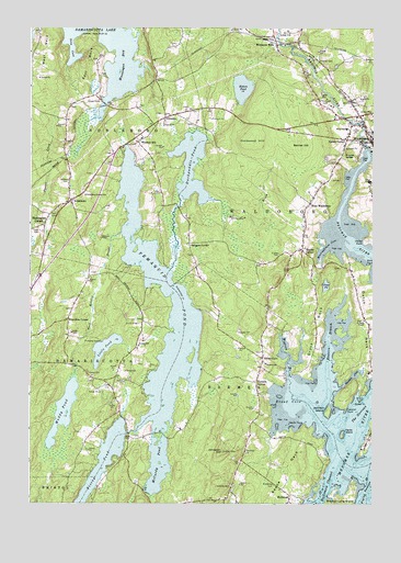
Waldoboro West, ME USGS Topographic Map
Click on map above to begin viewing in our Map Viewer.

This topographic map contains these locations and features:
Feature Name Type Latitude Longitude GNIS ID View Map
A D Gray Middle SchoolSchoolN44.0976°W69.3753°1909698View Map
Back Meadow BrookStreamN44.0712°W69.4664°561409View Map
Beaverdam BrookStreamN44.0615°W69.4487°561970View Map
Benner HillSummitN44.0946°W69.4022°562049View Map
Biscay PondLakeN44.0051°W69.4771°562371View Map
BremenPopulated PlaceN44.0015°W69.4287°580747View Map
Bremen Fire DepartmentBuildingN44.0030°W69.4584°2735794View Map
Bremen Post OfficePost OfficeN44.0054°W69.4102°2768960View Map
Bremen Public LibraryBuildingN44.0370°W69.4147°2738328View Map
Bremen Rescue First RespondersBuildingN44.0141°W69.4208°2666793View Map
Bremen SchoolSchoolN44.0367°W69.4137°562933View Map
Bremen Union ChurchChurchN44.0173°W69.4209°1909730View Map
Bremen Volunteer Fire DepartmentBuildingN44.0141°W69.4209°2552890View Map
Broad CoveBayN44.0267°W69.4037°562993View Map
Broad CovePopulated PlaceN44.0379°W69.4148°562999View Map
Butter PointCapeN44.0273°W69.3792°563303View Map
Cordwood HillSummitN44.0949°W69.4186°564359View Map
Creamer CemeteryCemeteryN44.1162°W69.3948°564504View Map
Damariscotta Montessori SchoolSchoolN44.0878°W69.4752°2738189View Map
Deep CoveBayN44.1176°W69.4845°564949View Map
Duck Puddle CampgroundLocaleN44.0729°W69.4589°1909770View Map
Duckpuddle PondLakeN44.0888°W69.4411°565367View Map
Dunbar CemeteryCemeteryN44.0851°W69.4859°565396View Map
Dutch Neck CemeteryCemeteryN44.0483°W69.3787°2736811View Map
East NeckCapeN44.1206°W69.4781°565643View Map
Eastern BranchStreamN44.0281°W69.3912°565710View Map
Eugley CemeteryCemeteryN44.0656°W69.4089°565950View Map
Eugley CornerPopulated PlaceN44.0667°W69.4006°565951View Map
Evergreen CemeteryCemeteryN44.0051°W69.4106°565964View Map
First Baptist ChurchChurchN44.0795°W69.4842°1909787View Map
German Protestant CemeteryCemeteryN44.0900°W69.3909°2712747View Map
GlendonPopulated PlaceN44.1012°W69.4506°579334View Map
Gross NeckCapeN44.0456°W69.3956°567349View Map
Gross PondLakeN44.0573°W69.3920°567350View Map
Hall CemeteryCemeteryN44.0765°W69.4909°567499View Map
Hardy IslandIslandN44.0184°W69.3856°567635View Map
Harrington CornerPopulated PlaceN44.0734°W69.4948°567677View Map
Havener CoveBayN44.0334°W69.3817°567770View Map
Havener PointCapeN44.0248°W69.3845°567771View Map
Heath PointCapeN44.0206°W69.3995°567878View Map
Hillside CemeteryCemeteryN44.0048°W69.4259°568071View Map
Hoffse PointCapeN44.0690°W69.3778°581438View Map
Johnson IslandIslandN44.0242°W69.3912°568929View Map
Johnston HillSummitN44.0137°W69.4295°568940View Map
Jones NeckCapeN44.0173°W69.3756°581443View Map
Kalers CornerPopulated PlaceN44.0959°W69.3845°569038View Map
Kalers PondLakeN44.1091°W69.4227°569039View Map
Knowlton CornerPopulated PlaceN44.0481°W69.4859°579458View Map
Lake Pemaquid CampgroundLocaleN44.0456°W69.4481°1909831View Map
Little PondLakeN44.0410°W69.4724°569971View Map
McCurdy PondLakeN44.0100°W69.4530°570967View Map
MedomakPopulated PlaceN44.0006°W69.4053°571108View Map
Medomak RiverStreamN44.0090°W69.3831°571109View Map
Medomak River ReservoirReservoirN44.0991°W69.3785°1774264View Map
Meetinghouse CoveBayN44.0670°W69.3914°571120View Map
Miller SchoolSchoolN44.0986°W69.3844°571378View Map
Minnehatta Fire StationBuildingN44.0996°W69.4543°2553006View Map
Muddy PondLakeN44.0242°W69.4876°571961View Map
Muscongus BayBayN44.1198°W69.4659°572007View Map
Noble MonumentParkN44.0806°W69.4842°1909880View Map
NobleboroPopulated PlaceN44.0795°W69.4850°572211View Map
Nobleboro Central SchoolSchoolN44.0806°W69.4802°572212View Map
Nobleboro Post OfficePost OfficeN44.0903°W69.4716°1909882View Map
Northeast Point LedgesBarN44.0106°W69.3859°581844View Map
Old German Meeting HouseChurchN44.0940°W69.3853°1909894View Map
Pemaquid PondLakeN44.0191°W69.4536°573147View Map
Procks LedgeSummitN44.0923°W69.3842°573829View Map
Riverside CemeteryCemeteryN44.1053°W69.3912°574251View Map
Saint Pauls ChapelChurchN44.0481°W69.3778°574746View Map
Sprague CornerPopulated PlaceN44.0684°W69.4412°579733View Map
The NarrowsChannelN44.0234°W69.3809°576850View Map
Town of DamariscottaCivilN44.0345°W69.4921°582432View Map
Town of NobleboroCivilN44.1060°W69.4769°582627View Map
Trash CemeteryCemeteryN44.0720°W69.4967°580008View Map
Turners CornerPopulated PlaceN44.0315°W69.4170°577439View Map
WaldoboroPopulated PlaceN44.0954°W69.3756°577782View Map
Waldoboro DamDamN44.0991°W69.3785°1774263View Map
Waldoboro Emergency Medical Ambulance ServiceBuildingN44.1031°W69.3793°2666759View Map
Waldoboro Police DepartmentBuildingN44.1031°W69.3792°2735931View Map
Waldoboro Volunteer Fire DepartmentBuildingN44.1031°W69.3793°2552891View Map
West NeckCapeN44.1240°W69.4937°578179View Map
West WaldoboroPopulated PlaceN44.0790°W69.3978°578235View Map
Western BrookStreamN44.0323°W69.4039°578245View Map
Winslow HillPopulated PlaceN44.0951°W69.4603°579847View Map
Winslows MillsPopulated PlaceN44.1204°W69.4098°579848View Map
Woltz PointCapeN44.0623°W69.3767°581511View Map

Note: Coordinates in the location and feature list above are referenced to NAD83 datum.


Copyright (C) 2008-2024 Ryan Niemi / Sunset Dynamics ... All Rights Reserved