TopoQuest Logo
Do you find TopoQuest useful?
Help keep TopoQuest running and adding new maps/features by donating!
Bitcoin:  19c7KJd3qBynnjoSw5npx9KScwjBe4ifkT
Litecoin:  LXs6TkuXGGXo1vDsWCkWVdjQX94eUKd6ui
Home View Maps Find Maps Find Places Resources & Links


White East, Georgia Topographic Map

USGS Map Title: White East, GA
USGS Map MRC: 34084C6
DRG (GeoTIFF) Download: o34084c6.tif


Neighboring USGS Topographic Map Quads:


  Sonoraville, GA  
34084D7
 

  Fairmount, GA  
34084D6
 

  Ludville, GA  
34084D5
 

  White West, GA  
34084C7
 

  White East, GA  
34084C6
 

  Waleska, GA  
34084C5
 

  Cartersville, GA  
34084B7
 

  Allatoona Dam, GA  
34084B6
 

  South Canton, GA  
34084B5


Map MRC Location:

N35°
W85°
N35°
W84°
H8 H7 H6 H5 H4 H3 H2 H1
G8 G7 G6 G5 G4 G3 G2 G1
F8 F7 F6 F5 F4 F3 F2 F1
E8 E7 E6 E5 E4 E3 E2 E1
D8 D7 D6 D5 D4 D3 D2 D1
C8 C7 C6 C5 C4 C3 C2 C1
B8 B7 B6 B5 B4 B3 B2 B1
A8 A7 A6 A5 A4 A3 A2 A1
N34°
W85°
N34°
W84°

White East, GA USGS 1:24K Topographic Map Preview:
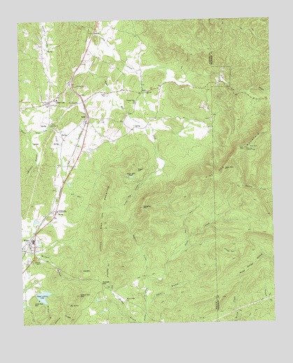
White East, GA USGS Topographic Map
Click on map above to begin viewing in our Map Viewer.

This topographic map contains these locations and features:
Feature Name Type Latitude Longitude GNIS ID View Map
Alexander HollowValleyN34.2642°W84.7060°310434View Map
Aubrey Family CemeteryCemeteryN34.2608°W84.7492°2364691View Map
Bartow County Fire Department Station 5BuildingN34.2820°W84.7449°2604240View Map
Bartow County Fire Department Station 8BuildingN34.3387°W84.7352°2604856View Map
Bear MountainSummitN34.3134°W84.6480°310949View Map
Big SpringSpringN34.2579°W84.7269°311415View Map
BolivarPopulated PlaceN34.3698°W84.7116°331204View Map
Cartersville Poor FarmLocaleN34.2968°W84.7333°334252View Map
City of WhiteCivilN34.2824°W84.7472°2405730View Map
Davis BranchStreamN34.2565°W84.6885°313331View Map
Fairview ChurchChurchN34.3481°W84.7166°314052View Map
Fairview Methodist Church CemeteryCemeteryN34.3483°W84.7178°2358709View Map
Faith ChurchChurchN34.3456°W84.6888°334275View Map
Faith Tabernacle Full Gospel Church CemeteryCemeteryN34.3453°W84.6894°2358729View Map
Falk LakeReservoirN34.3077°W84.7257°337113View Map
Grassy HollowValleyN34.2791°W84.6500°314784View Map
Guthrie CreekStreamN34.2679°W84.6872°356128View Map
Hanging MountainSummitN34.2979°W84.6891°315087View Map
Hickory Log Vocational SchoolSchoolN34.2933°W84.7310°315372View Map
Little Log CreekStreamN34.3081°W84.6888°317113View Map
Little Pine Log MountainSummitN34.2929°W84.7099°356365View Map
Little Red MountainSummitN34.2590°W84.7447°332243View Map
Maxwell BranchStreamN34.3293°W84.7458°317805View Map
Miller Chapel Independent Methodist Church CemeteryCemeteryN34.2592°W84.6992°2359129View Map
Millers ChapelChurchN34.2601°W84.6988°318274View Map
Neel LakeReservoirN34.3275°W84.6726°339386View Map
New Hope ChurchChurchN34.3415°W84.7202°319439View Map
Oak Hill Baptist Church CemeteryCemeteryN34.3458°W84.6864°2359449View Map
Oak Hill ChurchChurchN34.3456°W84.6849°319833View Map
Oak Hill School (historical)SchoolN34.3418°W84.6919°335441View Map
Olive Vine CemeteryCemeteryN34.3330°W84.7347°2359469View Map
Olive Vine ChurchChurchN34.3326°W84.7341°320053View Map
Pine LogPopulated PlaceN34.3429°W84.7322°356468View Map
Pine Log CampgroundLocaleN34.3495°W84.7255°335442View Map
Pine Log Elementary SchoolSchoolN34.3412°W84.7488°334329View Map
Pine Log Lookout TowerTowerN34.3212°W84.6374°344317View Map
Pine Log MountainSummitN34.3209°W84.6413°356470View Map
Pine Log Mountain Wildlife Management AreaParkN34.2918°W84.6708°334328View Map
Pine Log Post OfficePost OfficeN34.3423°W84.6683°351983View Map
Pine Log Tributary Structure Number 25 DamDamN34.3284°W84.6749°339385View Map
Pine Log Tributary Structure Number 66 DamDamN34.3084°W84.7249°337112View Map
Pine Log UMC CemeteryCemeteryN34.3487°W84.7260°335443View Map
Pine Log United Methodist ChurchChurchN34.3493°W84.7252°335444View Map
Pleasant Olive Baptist Church CemeteryCemeteryN34.3419°W84.6917°2359609View Map
Pleasant Olive ChurchChurchN34.3418°W84.6913°320923View Map
Red MountainSummitN34.2723°W84.7199°321395View Map
RydalPopulated PlaceN34.3354°W84.7155°332948View Map
Rydal Post OfficePost OfficeN34.3356°W84.7152°351984View Map
Sharp Top MountainSummitN34.2620°W84.7216°356531View Map
Sugar HillSummitN34.3137°W84.6910°333154View Map
Sugar Hill (historical)Populated PlaceN34.3109°W84.6860°334354View Map
Sugar Hill CreekStreamN34.3695°W84.7124°323725View Map
Sugar Hill PondLakeN34.3107°W84.6948°323726View Map
Upper Aubrey LakeReservoirN34.2618°W84.7399°324617View Map
Upper Aubrey Lake DamDamN34.2629°W84.7427°337124View Map
Vaughan CemeteryCemeteryN34.3056°W84.7322°334363View Map
WhitePopulated PlaceN34.2829°W84.7452°356633View Map
White Police DepartmentBuildingN34.2821°W84.7449°2733787View Map
White-Pine Log DivisionCivilN34.3187°W84.7383°1936645View Map
Wildcat BranchStreamN34.2587°W84.7385°325268View Map
Wildcat RidgeRidgeN34.2543°W84.7308°325282View Map
Wolfpen GapGapN34.2668°W84.7105°325516View Map
WTLK-TV (Rome)TowerN34.3131°W84.6485°352863View Map

Note: Coordinates in the location and feature list above are referenced to NAD83 datum.


Copyright (C) 2008-2024 Ryan Niemi / Sunset Dynamics ... All Rights Reserved