TopoQuest Logo
Do you find TopoQuest useful?
Help keep TopoQuest running and adding new maps/features by donating!
Bitcoin:  19c7KJd3qBynnjoSw5npx9KScwjBe4ifkT
Litecoin:  LXs6TkuXGGXo1vDsWCkWVdjQX94eUKd6ui
Home View Maps Find Maps Find Places Resources & Links


Walkerville West, Michigan Topographic Map

USGS Map Title: Walkerville West, MI
USGS Map MRC: 43086F2
DRG (GeoTIFF) Download: o43086f2.tif


Neighboring USGS Topographic Map Quads:


  Crystal Valley, MI  
43086G2
 

  Carr, MI  
43086G1


  Walkerville West, MI  
43086F2
 

  Walkerville East, MI  
43086F1


  Ferry, MI  
43086E2
 

  Hesperia, MI  
43086E1


Map MRC Location:

N44°
W87°
N44°
W86°
H8 H7 H6 H5 H4 H3 H2 H1
G8 G7 G6 G5 G4 G3 G2 G1
F8 F7 F6 F5 F4 F3 F2 F1
E8 E7 E6 E5 E4 E3 E2 E1
D8 D7 D6 D5 D4 D3 D2 D1
C8 C7 C6 C5 C4 C3 C2 C1
B8 B7 B6 B5 B4 B3 B2 B1
A8 A7 A6 A5 A4 A3 A2 A1
N43°
W87°
N43°
W86°

Walkerville West, MI USGS 1:24K Topographic Map Preview:
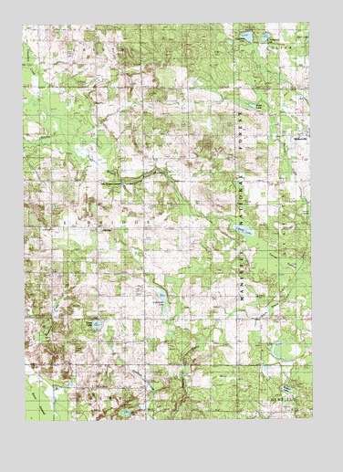
Walkerville West, MI USGS Topographic Map
Click on map above to begin viewing in our Map Viewer.

This topographic map contains these locations and features:
Feature Name Type Latitude Longitude GNIS ID View Map
Carpenter CemeteryCemeteryN43.6989°W86.1445°1619434View Map
Cleveland CreekStreamN43.7261°W86.2467°1619533View Map
Cobmoosa LakeLakeN43.6636°W86.1897°1619545View Map
ElbridgePopulated PlaceN43.6858°W86.2190°1619839View Map
Elbridge Community ChurchChurchN43.6861°W86.2175°2515744View Map
Elbridge Elementary SchoolSchoolN43.6864°W86.2217°2515745View Map
Elbridge Post Office (historical)Post OfficeN43.6858°W86.2189°2515401View Map
Elbridge Township CemeteryCemeteryN43.6853°W86.2183°2515851View Map
Evans LakeLakeN43.6554°W86.2186°1619872View Map
Fuller LakeLakeN43.7238°W86.1499°1619979View Map
Gale CemeteryCemeteryN43.6275°W86.1259°1619985View Map
Gale SchoolSchoolN43.6275°W86.1423°1619986View Map
Goodrich CemeteryCemeteryN43.6572°W86.1403°1620039View Map
Indian CemeteryCemeteryN43.7375°W86.2175°2515834View Map
Indian CemeteryCemeteryN43.7111°W86.1972°2515848View Map
Indian CemeteryCemeteryN43.7144°W86.2033°2515850View Map
Knox SwampSwampN43.6323°W86.2497°1620453View Map
Leavitt LakeLakeN43.6847°W86.1549°1620503View Map
Little Pebawma LakeLakeN43.7454°W86.1441°1620575View Map
North Ferry CemeteryCemeteryN43.6281°W86.1928°1621041View Map
Pebawma LakeLakeN43.7457°W86.1518°1621181View Map
Ralston LakeLakeN43.6344°W86.1364°1622381View Map
Rathburn SchoolSchoolN43.6258°W86.1990°1621348View Map
Raul Cemetery (historical)CemeteryN43.6356°W86.1972°2515833View Map
Routley CreekStreamN43.7239°W86.2409°1621453View Map
Saint Joseph's Catholic CemeteryCemeteryN43.7122°W86.1972°2515849View Map
Saint Josephs ChurchChurchN43.7111°W86.1990°1621484View Map
Sparks LakeLakeN43.6276°W86.2059°1621716View Map
Township of ElbridgeCivilN43.6865°W86.2179°1626223View Map
Twin Bridges CornersLocaleN43.7006°W86.2076°1622382View Map
Village of WalkervilleCivilN43.7143°W86.1262°2400085View Map
Walkerville CemeteryCemeteryN43.7103°W86.1375°2515847View Map
WCXT-FM (Hart)TowerN43.6761°W86.2392°1625410View Map

Note: Coordinates in the location and feature list above are referenced to NAD83 datum.


Copyright (C) 2008-2025 Ryan Niemi / Sunset Dynamics ... All Rights Reserved