TopoQuest Logo
Do you find TopoQuest useful?
Help keep TopoQuest running and adding new maps/features by donating!
Bitcoin:  19c7KJd3qBynnjoSw5npx9KScwjBe4ifkT
Litecoin:  LXs6TkuXGGXo1vDsWCkWVdjQX94eUKd6ui
Home View Maps Find Maps Find Places Resources & Links


Durand, Georgia Topographic Map

USGS Map Title: Durand, GA
USGS Map MRC: 32084H7
DRG (GeoTIFF) Download: o32084h7.tif


Neighboring USGS Topographic Map Quads:


  Mountville, GA  
33084A8
 

  Odessadale, GA  
33084A7
 

  Greenville, GA  
33084A6
 

  Hilyer, GA  
32084H8
 

  Durand, GA  
32084H7
 

  Warm Springs, GA  
32084H6
 

  Pine Mountain SW, GA  
32084G8
 

  Pine Mountain, GA  
32084G7
 

  Shiloh, GA  
32084G6


Map MRC Location:

N33°
W85°
N33°
W84°
H8 H7 H6 H5 H4 H3 H2 H1
G8 G7 G6 G5 G4 G3 G2 G1
F8 F7 F6 F5 F4 F3 F2 F1
E8 E7 E6 E5 E4 E3 E2 E1
D8 D7 D6 D5 D4 D3 D2 D1
C8 C7 C6 C5 C4 C3 C2 C1
B8 B7 B6 B5 B4 B3 B2 B1
A8 A7 A6 A5 A4 A3 A2 A1
N32°
W85°
N32°
W84°

Durand, GA USGS 1:24K Topographic Map Preview:
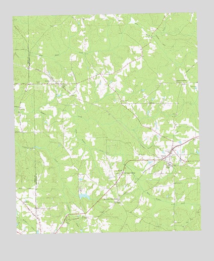
Durand, GA USGS Topographic Map
Click on map above to begin viewing in our Map Viewer.

This topographic map contains these locations and features:
Feature Name Type Latitude Longitude GNIS ID View Map
Arbor ChapelChurchN32.9490°W84.7835°310599View Map
Bethlehem ChurchChurchN32.9024°W84.7669°311237View Map
Caldwell-Williams CemeteryCemeteryN32.8829°W84.7924°1946138View Map
Cameo (historical)Populated PlaceN32.8843°W84.8191°346845View Map
Clemens CemeteryCemeteryN32.9576°W84.7508°312729View Map
Coplan-Perry CemeteryCemeteryN32.9001°W84.7824°346852View Map
County LinePopulated PlaceN32.8782°W84.7680°346853View Map
County Line CemeteryCemeteryN32.8801°W84.7683°346854View Map
County Line ChurchChurchN32.8799°W84.7683°355337View Map
Dallas Mill (historical)LocaleN32.9451°W84.8610°346856View Map
DurandPopulated PlaceN32.9171°W84.7738°355578View Map
Glanton CemeteryCemeteryN32.9335°W84.8691°1673206View Map
Greer and Robertson CemeteryCemeteryN32.9482°W84.7969°346873View Map
Grier CemeteryCemeteryN32.9623°W84.8449°314897View Map
Hardy CemeteryCemeteryN32.9471°W84.8708°356172View Map
Hills LakeReservoirN32.9151°W84.7999°340414View Map
Hills Lake DamDamN32.9151°W84.7999°340413View Map
Hunters CrossroadPopulated PlaceN32.9593°W84.7605°326334View Map
McGees PondReservoirN32.8962°W84.8288°337528View Map
McKee CemeteryCemeteryN32.9193°W84.7913°317936View Map
Meriwether County Volunteer Fire Department Station 10BuildingN32.9175°W84.7707°2604512View Map
Meriwether County Volunteer Fire Department Station 8BuildingN32.9614°W84.8567°2604828View Map
Meriwether White SulphurLocaleN32.8935°W84.8052°318044View Map
Mitcham DamDamN32.9201°W84.7516°340196View Map
Mitcham LakeReservoirN32.9198°W84.7510°340197View Map
Oak GrovePopulated PlaceN32.8935°W84.8702°332525View Map
Ogletree CemeteryCemeteryN32.9505°W84.8021°319924View Map
Ogletree CemeteryCemeteryN32.9612°W84.8583°319925View Map
Sharp CemeteryCemeteryN32.9348°W84.7660°322793View Map
Spring ChapelChurchN32.8926°W84.8055°323372View Map
Spring Chapel CemeteryCemeteryN32.8793°W84.8013°1946139View Map
StovallPopulated PlaceN32.9610°W84.8519°333138View Map
Stovall Baptist ChurchChurchN32.9635°W84.8497°346918View Map
Tigner CemeteryCemeteryN32.9782°W84.7877°346921View Map
Tigners Cross RoadsLocaleN32.9660°W84.8163°346922View Map
Trinity ChurchChurchN32.9124°W84.7716°324309View Map
Trinity ChurchChurchN32.9204°W84.7705°324310View Map
Tucker CemeteryCemeteryN32.8773°W84.8035°1946140View Map
Vandegrift DamDamN32.8968°W84.8316°337527View Map
Warm Springs DivisionCivilN32.9135°W84.7581°1936625View Map
White Sulphur CreekStreamN32.9421°W84.8344°325199View Map
White Sulphur SpringsPopulated PlaceN32.9079°W84.8033°333415View Map
Williamson LakeReservoirN32.9418°W84.7999°340412View Map
Williamson Lake DamDamN32.9418°W84.7999°340411View Map
Wilson ChapelChurchN32.9604°W84.8424°325429View Map
Woods CemeteryCemeteryN32.9262°W84.7996°325549View Map

Note: Coordinates in the location and feature list above are referenced to NAD83 datum.


Copyright (C) 2008-2024 Ryan Niemi / Sunset Dynamics ... All Rights Reserved