TopoQuest Logo
Do you find TopoQuest useful?
Help keep TopoQuest running and adding new maps/features by donating!
Bitcoin:  19c7KJd3qBynnjoSw5npx9KScwjBe4ifkT
Litecoin:  LXs6TkuXGGXo1vDsWCkWVdjQX94eUKd6ui
Home View Maps Find Maps Find Places Resources & Links


Warm Springs Canyon, Arizona Topographic Map

USGS Map Title: Warm Springs Canyon, AZ
USGS Map MRC: 36112F3
DRG (GeoTIFF) Download: o36112f3.tif


Neighboring USGS Topographic Map Quads:


  White Sage Flat, AZ  
36112G4
 

  Le Fevre Ridge, AZ  
36112G3
 

  Cooper Ridge, AZ  
36112G2
 

  Toothpick Ridge, AZ  
36112F4
 

  Warm Springs Canyon, AZ  
36112F3
 

  Jacob Lake, AZ  
36112F2
 

  Sowats Spring, AZ  
36112E4
 

  Big Springs, AZ  
36112E3
 

  Telephone Hill, AZ  
36112E2


Map MRC Location:

N37°
W113°
N37°
W112°
H8 H7 H6 H5 H4 H3 H2 H1
G8 G7 G6 G5 G4 G3 G2 G1
F8 F7 F6 F5 F4 F3 F2 F1
E8 E7 E6 E5 E4 E3 E2 E1
D8 D7 D6 D5 D4 D3 D2 D1
C8 C7 C6 C5 C4 C3 C2 C1
B8 B7 B6 B5 B4 B3 B2 B1
A8 A7 A6 A5 A4 A3 A2 A1
N36°
W113°
N36°
W112°

Warm Springs Canyon, AZ USGS 1:24K Topographic Map Preview:
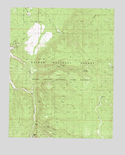
Warm Springs Canyon, AZ USGS Topographic Map
Click on map above to begin viewing in our Map Viewer.

This topographic map contains these locations and features:
Feature Name Type Latitude Longitude GNIS ID View Map
Back RidgeTankReservoirN36.7067°W112.2783°2091708View Map
Beef TankReservoirN36.7244°W112.2581°2091707View Map
Buck LakeLakeN36.7029°W112.3017°2067View Map
Buck RidgeRidgeN36.7017°W112.2896°2073View Map
Buck Ridge Microwave TowerTowerN36.7142°W112.3092°2094796View Map
Buck Ridge PointCliffN36.6983°W112.3382°2074View Map
Fracas CanyonValleyN36.6867°W112.2649°4816View Map
Fracas Canyon TankReservoirN36.6651°W112.2656°44660View Map
Hidden Lake ApronReservoirN36.7450°W112.2803°2091706View Map
Hidden Lake Trick TankReservoirN36.7453°W112.2816°24064View Map
Jacob Canyon ApronReservoirN36.7303°W112.3192°2091705View Map
Jacob Canyon TankReservoirN36.7267°W112.3149°44664View Map
Judd TankReservoirN36.7493°W112.3731°20836View Map
Lambs LakeLakeN36.6947°W112.2531°6860View Map
Magnum Springs Ranger StationLocaleN36.6292°W112.2646°20887View Map
Mangum CampLocaleN36.6283°W112.3450°2091710View Map
Mangum CanyonValleyN36.6269°W112.3471°7647View Map
Mangum SpringsPopulated PlaceN36.6261°W112.3493°24505View Map
Middle Oak PointCliffN36.6605°W112.3155°7990View Map
Moquitch CampLocaleN36.6386°W112.3424°8274View Map
Moquitch CanyonValleyN36.6397°W112.3452°8275View Map
Moquitch PointCliffN36.6278°W112.3213°8276View Map
Moquitch Point TankReservoirN36.6258°W112.3133°2091711View Map
Moquitch SpringSpringN36.6330°W112.3263°8277View Map
Mud LakeLakeN36.6353°W112.2938°8352View Map
Naile PointCliffN36.6253°W112.3352°8482View Map
North Fork Moquitch CanyonValleyN36.6372°W112.3380°8728View Map
North Fork Oak CanyonValleyN36.6753°W112.3407°8729View Map
North Oak PointsSummitN36.6744°W112.3096°8752View Map
North Oak TankReservoirN36.6722°W112.2867°2091709View Map
Oak CanyonValleyN36.6692°W112.3488°8857View Map
Oak CorralLocaleN36.6689°W112.3488°44683View Map
Oak SpringSpringN36.6773°W112.3371°8882View Map
RyanPopulated PlaceN36.6883°W112.3493°24592View Map
South Fork Moquitch CanyonValleyN36.6339°W112.3352°11599View Map
South Fork Oak CanyonValleyN36.6647°W112.3241°11600View Map
South Oak ApronReservoirN36.6347°W112.3172°2091712View Map
South Oak PointsSummitN36.6453°W112.3288°11625View Map
Suicide RidgeRidgeN36.7200°W112.3649°11924View Map
Tilton SpringsSpringN36.6590°W112.3408°12464View Map
Warm SpringsSpringN36.6945°W112.3119°13353View Map
Warm Springs LakeLakeN36.6903°W112.2819°13356View Map
Warm Springs PointCliffN36.6825°W112.3321°13357View Map

Note: Coordinates in the location and feature list above are referenced to NAD83 datum.


Copyright (C) 2008-2025 Ryan Niemi / Sunset Dynamics ... All Rights Reserved