TopoQuest Logo
Do you find TopoQuest useful?
Help keep TopoQuest running and adding new maps/features by donating!
Bitcoin:  19c7KJd3qBynnjoSw5npx9KScwjBe4ifkT
Litecoin:  LXs6TkuXGGXo1vDsWCkWVdjQX94eUKd6ui
Home View Maps Find Maps Find Places Resources & Links


Warren, Arkansas Topographic Map

USGS Map Title: Warren, AR
USGS Map MRC: 33092E1
DRG (GeoTIFF) Download: o33092e1.tif


Neighboring USGS Topographic Map Quads:


  McKinney, AR  
33092F2
 

  Warren NE, AR  
33092F1
 

  Wilmar North, AR  
33091F8
 

  Farmville, AR  
33092E2
 

  Warren, AR  
33092E1
 

  Wilmar South, AR  
33091E8
 

  Hermitage, AR  
33092D2
 

  Sumpter, AR  
33092D1
 

  Longview, AR  
33091D8


Map MRC Location:

N34°
W93°
N34°
W92°
H8 H7 H6 H5 H4 H3 H2 H1
G8 G7 G6 G5 G4 G3 G2 G1
F8 F7 F6 F5 F4 F3 F2 F1
E8 E7 E6 E5 E4 E3 E2 E1
D8 D7 D6 D5 D4 D3 D2 D1
C8 C7 C6 C5 C4 C3 C2 C1
B8 B7 B6 B5 B4 B3 B2 B1
A8 A7 A6 A5 A4 A3 A2 A1
N33°
W93°
N33°
W92°

Warren, AR USGS 1:24K Topographic Map Preview:
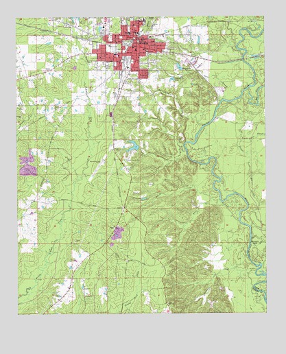
Warren, AR USGS Topographic Map
Click on map above to begin viewing in our Map Viewer.

This topographic map contains these locations and features:
Feature Name Type Latitude Longitude GNIS ID View Map
Adams/Singer CemeteryCemeteryN33.5362°W92.0765°45781View Map
Antioch ChurchChurchN33.5862°W92.1049°45893View Map
Atkins PondReservoirN33.5988°W92.0467°76210View Map
Atkins Pond DamDamN33.5984°W92.0468°81195View Map
Berry CreekStreamN33.5396°W92.0135°46408View Map
Big SloughStreamN33.5365°W92.0076°76344View Map
Bradley County CourthouseBuildingN33.6148°W92.0637°60539View Map
Bradley County LakeReservoirN33.6235°W92.0960°81194View Map
Bradley County Medical CenterHospitalN33.6105°W92.0592°60540View Map
Bradley County Memorial Hospital HeliportAirportN33.6104°W92.0593°83857View Map
Bradley County Sheriff's OfficeBuildingN33.6152°W92.0633°2118707View Map
Bradley County Volunteer Fire DepartmentBuildingN33.6108°W92.0782°2116187View Map
Bradley High SchoolSchoolN33.6240°W92.0612°46897View Map
Brooks CreekStreamN33.5484°W92.0276°46981View Map
CarmelPopulated PlaceN33.5448°W92.0715°56952View Map
Carmel Church (historical)ChurchN33.5440°W92.0718°60526View Map
Carmel School (historical)SchoolN33.5523°W92.0685°60541View Map
Carmichael CreekStreamN33.5790°W92.0315°47472View Map
City of WarrenCivilN33.6113°W92.0675°2405674View Map
Cloquet (historical)Populated PlaceN33.6173°W92.0974°60533View Map
Coker CemeteryCemeteryN33.5693°W92.0735°47895View Map
Eastside Elementary SchoolSchoolN33.6212°W92.0565°83422View Map
Eastside Primary SchoolSchoolN33.6213°W92.0560°2039350View Map
Emergency Ambulance Service WarrenBuildingN33.6093°W92.0602°2119035View Map
Germany CreekStreamN33.5090°W92.0040°49384View Map
Gin House SloughStreamN33.5723°W92.0124°49425View Map
Hickory Springs School (historical)SchoolN33.5009°W92.1115°60525View Map
Hudspeth LandingLocaleN33.5359°W92.0074°60530View Map
Log SloughStreamN33.5582°W92.0068°51387View Map
Oakland CemeteryCemeteryN33.6065°W92.0554°52951View Map
Old RiverGutN33.5921°W92.0037°53018View Map
Reeps LakeReservoirN33.6039°W92.0430°77307View Map
Reeps Lake DamDamN33.6034°W92.0418°80747View Map
River IslandFlatN33.5148°W92.0015°60529View Map
Saline Baptist ChurchChurchN33.5040°W92.0499°78282View Map
Saline CemeteryCemeteryN33.5045°W92.0493°60527View Map
Saline School (historical)SchoolN33.5037°W92.0493°60528View Map
Suttons Ferry (historical)CrossingN33.5829°W92.0254°60531View Map
Tenmile CreekStreamN33.5943°W92.0093°78533View Map
Town and Country Shopping CenterLocaleN33.6171°W92.0718°60536View Map
Town BranchStreamN33.5898°W92.0215°55612View Map
Township of PenningtonCivilN33.6041°W92.0953°63693View Map
Union CemeteryCemeteryN33.6248°W92.0679°55785View Map
WarrenPopulated PlaceN33.6126°W92.0646°78699View Map
Warren Country ClubLocaleN33.5648°W92.0701°82582View Map
Warren Country Club LakeReservoirN33.5697°W92.0670°80749View Map
Warren Country Club Lake DamDamN33.5684°W92.0651°80748View Map
Warren Fire Department Station 1BuildingN33.6156°W92.0627°2117273View Map
Warren Fire Station 2BuildingN33.6140°W92.0823°2117274View Map
Warren High SchoolSchoolN33.6184°W92.0680°60537View Map
Warren Municipal AirportAirportN33.5635°W92.0816°83856View Map
Warren Police DepartmentBuildingN33.6156°W92.0625°2118708View Map
Warren Shopping CenterLocaleN33.6101°W92.0729°60535View Map
Westside Elementary SchoolSchoolN33.6129°W92.0785°83529View Map
Willoughby School (historical)SchoolN33.6248°W92.1079°60534View Map

Note: Coordinates in the location and feature list above are referenced to NAD83 datum.


Copyright (C) 2008-2025 Ryan Niemi / Sunset Dynamics ... All Rights Reserved