TopoQuest Logo
Do you find TopoQuest useful?
Help keep TopoQuest running and adding new maps/features by donating!
Bitcoin:  19c7KJd3qBynnjoSw5npx9KScwjBe4ifkT
Litecoin:  LXs6TkuXGGXo1vDsWCkWVdjQX94eUKd6ui
Home View Maps Find Maps Find Places Resources & Links


Sumpter, Arkansas Topographic Map

USGS Map Title: Sumpter, AR
USGS Map MRC: 33092D1
DRG (GeoTIFF) Download: o33092d1.tif


Neighboring USGS Topographic Map Quads:


  Farmville, AR  
33092E2
 

  Warren, AR  
33092E1
 

  Wilmar South, AR  
33091E8
 

  Hermitage, AR  
33092D2
 

  Sumpter, AR  
33092D1
 

  Longview, AR  
33091D8
 

  Marsden, AR  
33092C2
 

  Vick, AR  
33092C1
 

  Milo, AR  
33091C8


Map MRC Location:

N34°
W93°
N34°
W92°
H8 H7 H6 H5 H4 H3 H2 H1
G8 G7 G6 G5 G4 G3 G2 G1
F8 F7 F6 F5 F4 F3 F2 F1
E8 E7 E6 E5 E4 E3 E2 E1
D8 D7 D6 D5 D4 D3 D2 D1
C8 C7 C6 C5 C4 C3 C2 C1
B8 B7 B6 B5 B4 B3 B2 B1
A8 A7 A6 A5 A4 A3 A2 A1
N33°
W93°
N33°
W92°

Sumpter, AR USGS 1:24K Topographic Map Preview:
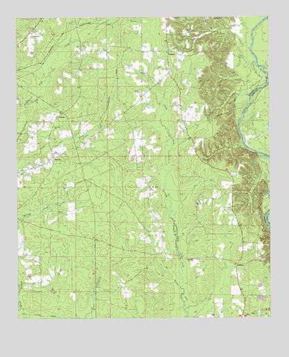
Sumpter, AR USGS Topographic Map
Click on map above to begin viewing in our Map Viewer.

This topographic map contains these locations and features:
Feature Name Type Latitude Longitude GNIS ID View Map
Berry Island (historical)IslandN33.4646°W92.0090°78965View Map
Bradley CreekStreamN33.4868°W92.0093°60587View Map
Colvin School (historical)SchoolN33.4865°W92.0807°60586View Map
Ferrell (historical)Populated PlaceN33.4021°W92.0537°60578View Map
Geopel (historical)Populated PlaceN33.4296°W92.0751°60581View Map
Germany BayBayN33.4268°W92.0010°60589View Map
Gin House BranchStreamN33.3821°W92.1246°60575View Map
Green Hill Church (historical)ChurchN33.4682°W92.0437°60582View Map
Hickory Springs CemeteryCemeteryN33.4934°W92.1171°60577View Map
Hickory Springs Presbyterian ChurchChurchN33.4934°W92.1171°77176View Map
Hopewell School (historical)SchoolN33.3854°W92.1082°60574View Map
Little Snake CreekStreamN33.3782°W92.0426°60591View Map
MannstownPopulated PlaceN33.4768°W92.0496°60583View Map
Mount OlivePopulated PlaceN33.4290°W92.0590°57129View Map
Mount Olive CemeteryCemeteryN33.4293°W92.0587°60580View Map
Mount Olive ChurchChurchN33.4287°W92.0587°60579View Map
New Hope School (historical)SchoolN33.4862°W92.0501°60585View Map
PattsvillePopulated PlaceN33.4421°W92.1068°58335View Map
Pattsville CemeteryCemeteryN33.4543°W92.1065°53228View Map
Pleasant Ridge School (historical)SchoolN33.4437°W92.0371°60588View Map
Sandtuck (historical)Populated PlaceN33.4848°W92.1096°60576View Map
SimpsonPopulated PlaceN33.4587°W92.1043°58627View Map
SmearnyPopulated PlaceN33.3973°W92.0162°78384View Map
Smearny CemeteryCemeteryN33.3976°W92.0154°60593View Map
Sulphur BranchStreamN33.4473°W92.0132°60590View Map
SumpterPopulated PlaceN33.4857°W92.0493°57199View Map
Sumpter Methodist ChurchChurchN33.4837°W92.0501°60584View Map
Sumpter Rural Fire StationBuildingN33.4856°W92.0502°2117191View Map
Township of MarionCivilN33.4641°W92.0420°63689View Map
Wilson ChapelChurchN33.3973°W92.0168°60592View Map

Note: Coordinates in the location and feature list above are referenced to NAD83 datum.


Copyright (C) 2008-2025 Ryan Niemi / Sunset Dynamics ... All Rights Reserved