TopoQuest Logo
Do you find TopoQuest useful?
Help keep TopoQuest running and adding new maps/features by donating!
Bitcoin:  19c7KJd3qBynnjoSw5npx9KScwjBe4ifkT
Litecoin:  LXs6TkuXGGXo1vDsWCkWVdjQX94eUKd6ui
Home View Maps Find Maps Find Places Resources & Links


Longview, Arkansas Topographic Map

USGS Map Title: Longview, AR
USGS Map MRC: 33091D8
DRG (GeoTIFF) Download: o33091d8.tif


Neighboring USGS Topographic Map Quads:


  Warren, AR  
33092E1
 

  Wilmar South, AR  
33091E8
 

  Monticello South, AR  
33091E7
 

  Sumpter, AR  
33092D1
 

  Longview, AR  
33091D8
 

  Ladelle, AR  
33091D7
 

  Vick, AR  
33092C1
 

  Milo, AR  
33091C8
 

  Fountain Hill, AR  
33091C7


Map MRC Location:

N34°
W92°
N34°
W91°
H8 H7 H6 H5 H4 H3 H2 H1
G8 G7 G6 G5 G4 G3 G2 G1
F8 F7 F6 F5 F4 F3 F2 F1
E8 E7 E6 E5 E4 E3 E2 E1
D8 D7 D6 D5 D4 D3 D2 D1
C8 C7 C6 C5 C4 C3 C2 C1
B8 B7 B6 B5 B4 B3 B2 B1
A8 A7 A6 A5 A4 A3 A2 A1
N33°
W92°
N33°
W91°

Longview, AR USGS 1:24K Topographic Map Preview:
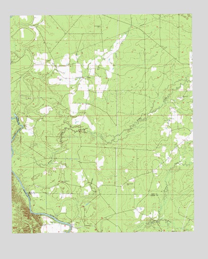
Longview, AR USGS Topographic Map
Click on map above to begin viewing in our Map Viewer.

This topographic map contains these locations and features:
Feature Name Type Latitude Longitude GNIS ID View Map
Bear CreekStreamN33.3771°W91.8829°62364View Map
Bethel Missionary Baptist ChurchChurchN33.4693°W91.9401°76314View Map
Brooks CemeteryCemeteryN33.3986°W91.9415°46979View Map
Brown CreekStreamN33.4223°W91.9982°76429View Map
Hales CemeteryCemeteryN33.4632°W91.9668°49766View Map
Holy Divine ChurchChurchN33.4523°W91.8818°50270View Map
Long View Ferry (historical)CrossingN33.3784°W91.9599°60594View Map
LongviewPopulated PlaceN33.3809°W91.9704°77551View Map
Moody (historical)Populated PlaceN33.4684°W91.9349°79044View Map
Mount Peter CemeteryCemeteryN33.4048°W91.9643°79045View Map
Mount Peter ChurchChurchN33.4046°W91.9637°52369View Map
Negro Bend (historical)Populated PlaceN33.4182°W91.9765°79052View Map
Ozment CemeteryCemeteryN33.4637°W91.9510°77940View Map
Panther CreekStreamN33.3818°W91.9001°53153View Map
Prairie Chapel CemeteryCemeteryN33.4027°W91.9213°53758View Map
Prairie Chapel Methodist Church (historical)ChurchN33.4032°W91.9221°79072View Map
Sixteenth Section CemeteryCemeteryN33.4932°W91.9376°54884View Map
Township of CrookCivilN33.4699°W91.9459°66513View Map
Trouble Island (historical)IslandN33.4284°W91.9993°79115View Map
ValleyLocaleN33.4643°W91.9471°78640View Map
Valley Methodist ChurchChurchN33.4640°W91.9496°79106View Map

Note: Coordinates in the location and feature list above are referenced to NAD83 datum.


Copyright (C) 2008-2025 Ryan Niemi / Sunset Dynamics ... All Rights Reserved