TopoQuest Logo
Do you find TopoQuest useful?
Help keep TopoQuest running and adding new maps/features by donating!
Bitcoin:  19c7KJd3qBynnjoSw5npx9KScwjBe4ifkT
Litecoin:  LXs6TkuXGGXo1vDsWCkWVdjQX94eUKd6ui
Home View Maps Find Maps Find Places Resources & Links


Washougal, Washington Topographic Map

USGS Map Title: Washougal, WA
USGS Map MRC: 45122E3
DRG (GeoTIFF) Download: o45122e3.tif


Neighboring USGS Topographic Map Quads:


  Lacamas Creek, WA  
45122F4
 

  Larch Mountain, WA  
45122F3
 

  Bobs Mountain, WA  
45122F2
 

  Camas, WA  
45122E4
 

  Washougal, WA  
45122E3
 

  Bridal Veil, OR  
45122E2
 

  Damascus, OR  
45122D4
 

  Sandy, OR  
45122D3
 

  Bull Run, OR  
45122D2


Map MRC Location:

N46°
W123°
N46°
W122°
H8 H7 H6 H5 H4 H3 H2 H1
G8 G7 G6 G5 G4 G3 G2 G1
F8 F7 F6 F5 F4 F3 F2 F1
E8 E7 E6 E5 E4 E3 E2 E1
D8 D7 D6 D5 D4 D3 D2 D1
C8 C7 C6 C5 C4 C3 C2 C1
B8 B7 B6 B5 B4 B3 B2 B1
A8 A7 A6 A5 A4 A3 A2 A1
N45°
W123°
N45°
W122°

Washougal, WA USGS 1:24K Topographic Map Preview:
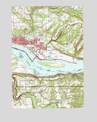
Washougal, WA USGS Topographic Map
Click on map above to begin viewing in our Map Viewer.

This topographic map contains these locations and features:
Feature Name Type Latitude Longitude GNIS ID View Map
Big CreekStreamN45.5046°W122.3006°1138009View Map
Bonnie BrookStreamN45.5165°W122.3540°1130329View Map
Camas - Washougal Fire Department Station 43BuildingN45.5776°W122.3567°2619454View Map
Camp CollinsLocaleN45.5015°W122.3056°1118495View Map
Campen CreekStreamN45.5754°W122.3140°1503765View Map
Cemetery HillSummitN45.5190°W122.2968°1136136View Map
Chamberlain HillSummitN45.5332°W122.3429°1136138View Map
Chanticleer PointSummitN45.5379°W122.2662°1118822View Map
Chatham IslandIslandN45.5415°W122.3334°1118839View Map
City of WashougalCivilN45.5812°W122.3433°2412189View Map
Columbia Gorge District Ranger Office (historical)LocaleN45.5187°W122.3401°1167416View Map
Columbia SchoolSchoolN45.5787°W122.3468°1504086View Map
CorbettPopulated PlaceN45.5318°W122.2912°1136174View Map
Corbett Community ChurchChurchN45.5275°W122.3094°2508051View Map
Corbett Grade SchoolSchoolN45.5295°W122.2965°2434962View Map
Corbett Post OfficePost OfficeN45.5312°W122.2925°1165088View Map
Corbett School (historical)SchoolN45.5401°W122.2845°1162127View Map
Corbett StationLocaleN45.5412°W122.2912°1167701View Map
Cottonwood PointCapeN45.5598°W122.3245°1504176View Map
Crampton ReservoirReservoirN45.5098°W122.3123°1130330View Map
Crown Point State ParkParkN45.5379°W122.2562°1140494View Map
Crusher (historical)LocaleN45.5493°W122.2695°1167758View Map
Crusher CreekStreamN45.5429°W122.2790°1130332View Map
Dabney State ParkParkN45.5173°W122.3534°1119655View Map
Dabney State Park Boat RampLocaleN45.5162°W122.3573°2700322View Map
East County Fire and Rescue Station 93BuildingN45.6227°W122.3523°2643356View Map
East County Fire and Rescue Station 94BuildingN45.6086°W122.3118°2643357View Map
East County Fire and Rescue Station 95BuildingN45.5772°W122.3271°2643358View Map
Excelsior High SchoolSchoolN45.5865°W122.3283°2474969View Map
Flag IslandIslandN45.5454°W122.3329°1120814View Map
Flagg IslandParkN45.5471°W122.3387°2058170View Map
Flagg Island ParkParkN45.5471°W122.3387°2040733View Map
Forgotten SpringsSpringN45.6221°W122.2898°1509718View Map
Four CornersLocaleN45.6071°W122.3101°1504998View Map
Gage Post Office (historical)Post OfficeN45.5190°W122.3298°1164373View Map
Gary IslandIslandN45.5548°W122.3473°1121070View Map
Gary Island ParkParkN45.5554°W122.3484°2040762View Map
Gary Island RangeChannelN45.5498°W122.3318°1156791View Map
Gause Elementary SchoolSchoolN45.5846°W122.3317°2474975View Map
Gibbons CreekStreamN45.5687°W122.3170°1505122View Map
Hathaway Elementary SchoolSchoolN45.5816°W122.3458°1530923View Map
Howard CanyonValleyN45.5154°W122.2770°1143844View Map
Hurlburt Post Office (historical)Post OfficeN45.5082°W122.2887°1165424View Map
Jemtegaard Middle SchoolSchoolN45.5751°W122.3093°1515220View Map
Keanes CreekStreamN45.5179°W122.3706°1130328View Map
Knieriem CanyonValleyN45.5179°W122.2759°1122812View Map
Lady Island and Upper RangeChannelN45.5440°W122.2748°1513320View Map
Lawton CreekStreamN45.5551°W122.2676°1506114View Map
Little Washougal RiverStreamN45.6071°W122.3426°1522318View Map
Mount NorwaySummitN45.6121°W122.2926°1507115View Map
Mount PleasantPopulated PlaceN45.5598°W122.2576°1512484View Map
Mountain View CemeteryCemeteryN45.5187°W122.2973°1124427View Map
Multnomah County Rural Fire Protection District 14 Station 61 SpringdaleBuildingN45.5192°W122.3361°2576817View Map
Multnomah County Rural Fire Protection District 14 Station 62 CorbettBuildingN45.5318°W122.2837°2576822View Map
Nichols HillSummitN45.6057°W122.2748°1506977View Map
Omar Gause SchoolSchoolN45.5848°W122.3309°1507185View Map
Onion RockBarN45.5423°W122.2690°1125000View Map
Orbit HeliportAirportN45.5679°W122.3193°1534024View Map
Orchard Hills Golf CourseLocaleN45.5804°W122.3290°1533192View Map
Ough ReefBarN45.5737°W122.3576°1507222View Map
Oxbow Park Boat RampLocaleN45.5039°W122.3083°2700095View Map
Page Post Office (historical)Post OfficeN45.5176°W122.2793°1164575View Map
Pleasant Farm AirportAirportN45.5624°W122.2579°2443413View Map
Point VancouverCapeN45.5560°W122.2670°1507538View Map
Portland Womens Forum State ParkParkN45.5340°W122.2601°1851918View Map
Pounder CemeteryCemeteryN45.5260°W122.2782°1125626View Map
Pounder CreekStreamN45.5121°W122.2837°1125627View Map
Price ReservoirReservoirN45.6035°W122.3684°1532653View Map
Price Reservoir DamDamN45.6032°W122.3679°1532652View Map
Rainbow CreekStreamN45.5415°W122.2679°1130333View Map
Reed IslandIslandN45.5521°W122.3043°1507765View Map
Reed Island RangeChannelN45.5443°W122.3026°1156792View Map
Rooster RockPillarN45.5437°W122.2512°1148720View Map
Rooster Rock (historical)LocaleN45.5410°W122.2531°1136704View Map
Rooster Rock ChannelChannelN45.5435°W122.2748°1135894View Map
Rooster Rock ChannelChannelN45.5440°W122.2748°1513319View Map
Rooster Rock Post Office (historical)Post OfficeN45.5410°W122.2531°1165881View Map
SandyLocaleN45.5423°W122.3576°1167819View Map
Smith CreekStreamN45.5132°W122.3376°1127113View Map
SpringdalePopulated PlaceN45.5190°W122.3298°1136776View Map
Springdale Community Bible ChurchChurchN45.5272°W122.3256°2508219View Map
Springdale School (historical)SchoolN45.5193°W122.3304°1162126View Map
Steigerwald LakeLakeN45.5673°W122.3040°1508717View Map
Steigerwald Lake National Wildlife RefugeParkN45.5657°W122.3063°2765515View Map
Sunnyside CemeteryCemeteryN45.6149°W122.3494°1508827View Map
Taylor (historical)LocaleN45.5385°W122.3145°1167829View Map
Taylor Post Office (historical)Post OfficeN45.5412°W122.2912°1164713View Map
Tunnel PointCapeN45.5426°W122.2756°1128304View Map
Tunnel Point ChannelChannelN45.5437°W122.2790°1156793View Map
Tunnel Point ChannelChannelN45.5443°W122.2943°1513318View Map
Walton CreekStreamN45.5662°W122.2631°1513995View Map
WashougalPopulated PlaceN45.5826°W122.3534°1512779View Map
Washougal Bus TerminalLocaleN45.5791°W122.3347°2474897View Map
Washougal High SchoolSchoolN45.5852°W122.3278°1509313View Map
Washougal Lower RangeChannelN45.5721°W122.3665°1156789View Map
Washougal Lower RangeChannelN45.5718°W122.3620°1513327View Map
Washougal Memorial CemeteryCemeteryN45.5882°W122.3326°1509314View Map
Washougal Police DepartmentBuildingN45.5776°W122.3574°2721881View Map
Washougal Post OfficePost OfficeN45.5782°W122.3543°2474920View Map
Washougal Upper RangeChannelN45.5623°W122.3456°1156790View Map
Washougal Upper RangeChannelN45.5679°W122.3515°1513322View Map
Winkler CreekStreamN45.6212°W122.2687°1529011View Map
Woodburn HillSummitN45.5960°W122.3540°1512811View Map

Note: Coordinates in the location and feature list above are referenced to NAD83 datum.


Copyright (C) 2008-2024 Ryan Niemi / Sunset Dynamics ... All Rights Reserved