TopoQuest Logo
Do you find TopoQuest useful?
Help keep TopoQuest running and adding new maps/features by donating!
Bitcoin:  19c7KJd3qBynnjoSw5npx9KScwjBe4ifkT
Litecoin:  LXs6TkuXGGXo1vDsWCkWVdjQX94eUKd6ui
Home View Maps Find Maps Find Places Resources & Links


Bondurant, Kentucky Topographic Map

USGS Map Title: Bondurant, KY
USGS Map MRC: 36089E3
DRG (GeoTIFF) Download: o36089e3.tif


Neighboring USGS Topographic Map Quads:


  Henderson Mound, MO  
36089F4
 

  Bayouville, MO  
36089F3
 

  Wolf Island, MO  
36089F2
 

  Hubbard Lake, MO  
36089E4
 

  Bondurant, KY  
36089E3
 

  Hickman, KY  
36089E2
 

  Tiptonville, TN  
36089D4
 

  Samburg, TN  
36089D3
 

  Clayton, TN  
36089D2


Map MRC Location:

N37°
W90°
N37°
W89°
H8 H7 H6 H5 H4 H3 H2 H1
G8 G7 G6 G5 G4 G3 G2 G1
F8 F7 F6 F5 F4 F3 F2 F1
E8 E7 E6 E5 E4 E3 E2 E1
D8 D7 D6 D5 D4 D3 D2 D1
C8 C7 C6 C5 C4 C3 C2 C1
B8 B7 B6 B5 B4 B3 B2 B1
A8 A7 A6 A5 A4 A3 A2 A1
N36°
W90°
N36°
W89°

Bondurant, KY USGS 1:24K Topographic Map Preview:
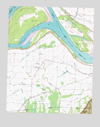
Bondurant, KY USGS Topographic Map
Click on map above to begin viewing in our Map Viewer.

This topographic map contains these locations and features:
Feature Name Type Latitude Longitude GNIS ID View Map
Anna LynnePopulated PlaceN36.5470°W89.2540°507401View Map
Bend of Island Number 8BendN36.6167°W89.3101°737848View Map
Blue PondLakeN36.5231°W89.2682°487531View Map
Blue PondPopulated PlaceN36.5284°W89.2571°2743890View Map
BondurantPopulated PlaceN36.5234°W89.3198°507548View Map
Chute of Island Number 7LakeN36.6080°W89.2823°755029View Map
Corner Stone ChurchChurchN36.5762°W89.3295°490121View Map
Dorena TowheadBarN36.5798°W89.2698°716989View Map
Fish PondLakeN36.5786°W89.3086°492107View Map
Fish Pond (historical)Populated PlaceN36.5753°W89.3282°2743902View Map
French PointCapeN36.5962°W89.3184°517058View Map
Hamby PondLakeN36.5485°W89.2905°493612View Map
Hogpen SloughGutN36.5334°W89.3509°494361View Map
Indian MoundSummitN36.5759°W89.3198°494978View Map
Island Number 7AreaN36.6042°W89.2820°755233View Map
Island Number 8IslandN36.6059°W89.3542°517190View Map
Johnson ChapelChurchN36.5520°W89.3281°495392View Map
LedfordPopulated PlaceN36.5301°W89.3026°508438View Map
MabelPopulated PlaceN36.5657°W89.2781°2743908View Map
Midway ChurchChurchN36.5331°W89.3573°498167View Map
MillerPopulated PlaceN36.5184°W89.3387°508605View Map
Mud SloughGutN36.5378°W89.3517°499019View Map
Number 8 SloughGutN36.5814°W89.3306°517255View Map
Open PondLakeN36.5473°W89.3659°499956View Map
Owens SloughStreamN36.5062°W89.2970°500079View Map
Owens SloughStreamN36.5065°W89.2970°1296583View Map
Pond SloughGutN36.5651°W89.3484°501062View Map
Rittenhouse SloughGutN36.5251°W89.3167°501974View Map
Running SloughStreamN36.5032°W89.2986°1300254View Map
Sand SloughLakeN36.5298°W89.3250°502939View Map
Sassafras Ridge (historical)Populated PlaceN36.5520°W89.3292°502999View Map
Sassafras Ridge CemeteryCemeteryN36.5687°W89.3279°2775565View Map
Sassafras Ridge ChurchChurchN36.5689°W89.3278°503000View Map
Three StatesPopulated PlaceN36.6178°W89.2759°730315View Map
Three States School (historical)SchoolN36.6164°W89.2848°746837View Map
Three States TowheadAreaN36.6023°W89.2892°727632View Map
TylerPopulated PlaceN36.5076°W89.3515°509256View Map
Western SchoolSchoolN36.5578°W89.3290°506496View Map
Willow PondLakeN36.5251°W89.3602°506869View Map
Willow SloughGutN36.5292°W89.3520°506870View Map

Note: Coordinates in the location and feature list above are referenced to NAD83 datum.


Copyright (C) 2008-2024 Ryan Niemi / Sunset Dynamics ... All Rights Reserved