TopoQuest Logo
Do you find TopoQuest useful?
Help keep TopoQuest running and adding new maps/features by donating!
Bitcoin:  19c7KJd3qBynnjoSw5npx9KScwjBe4ifkT
Litecoin:  LXs6TkuXGGXo1vDsWCkWVdjQX94eUKd6ui
Home View Maps Find Maps Find Places Resources & Links


Waverly, Missouri Topographic Map

USGS Map Title: Waverly, MO
USGS Map MRC: 39093B5
DRG (GeoTIFF) Download: o39093b5.tif


Neighboring USGS Topographic Map Quads:


  Norborne, MO  
39093C6
 

  Carrollton West, MO  
39093C5
 

  Carrollton East, MO  
39093C4
 

  Dover, MO  
39093B6
 

  Waverly, MO  
39093B5
 

  Grand Pass, MO  
39093B4
 

  Higginsville, MO  
39093A6
 

  Alma, MO  
39093A5
 

  Blackburn, MO  
39093A4


Map MRC Location:

N40°
W94°
N40°
W93°
H8 H7 H6 H5 H4 H3 H2 H1
G8 G7 G6 G5 G4 G3 G2 G1
F8 F7 F6 F5 F4 F3 F2 F1
E8 E7 E6 E5 E4 E3 E2 E1
D8 D7 D6 D5 D4 D3 D2 D1
C8 C7 C6 C5 C4 C3 C2 C1
B8 B7 B6 B5 B4 B3 B2 B1
A8 A7 A6 A5 A4 A3 A2 A1
N39°
W94°
N39°
W93°

Waverly, MO USGS 1:24K Topographic Map Preview:
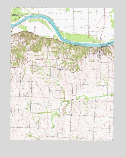
Waverly, MO USGS Topographic Map
Click on map above to begin viewing in our Map Viewer.

This topographic map contains these locations and features:
Feature Name Type Latitude Longitude GNIS ID View Map
Brown School (historical)SchoolN39.2192°W93.6158°714785View Map
Calloway School (historical)SchoolN39.2481°W93.5127°746999View Map
Catron CemeteryCemeteryN39.1472°W93.5394°715503View Map
Catron School (historical)SchoolN39.1378°W93.5222°747134View Map
Centerview School (historical)SchoolN39.1764°W93.5122°715667View Map
City of WaverlyCivilN39.2071°W93.5186°2397227View Map
Cragg BranchStreamN39.1614°W93.5588°730077View Map
Cuba (historical)Populated PlaceN39.2172°W93.6113°739640View Map
Edwards BranchStreamN39.2317°W93.6213°717413View Map
Erdman Lake DamDamN39.1517°W93.5319°763411View Map
Gliddens BranchStreamN39.2181°W93.5610°718528View Map
Hazel Hill Immanuel Church (historical)ChurchN39.1909°W93.5558°747135View Map
Hazel Hill School (historical)SchoolN39.1928°W93.5622°719295View Map
Higdon Lake DamDamN39.2017°W93.6169°763417View Map
Hodge BendBendN39.2344°W93.6178°2109520View Map
Jones Lake DamDamN39.1817°W93.5352°763413View Map
Moberly BendBendN39.2411°W93.5931°2109521View Map
Neal School (historical)SchoolN39.2411°W93.5491°747000View Map
Pfost Lake DamDamN39.2200°W93.5819°763414View Map
Rabbit IslandIslandN39.2178°W93.5210°725037View Map
Santa Fe Elementary SchoolSchoolN39.2076°W93.5266°726051View Map
Schmidt Lake DamDamN39.1834°W93.5452°763412View Map
Sidha Farms Lake DamDamN39.2017°W93.6069°763415View Map
Smith School (historical)SchoolN39.2453°W93.5905°746998View Map
Three Groves ChurchChurchN39.1484°W93.5522°727629View Map
Three Groves School (historical)SchoolN39.1500°W93.5660°747133View Map
Township of MiddletonCivilN39.1551°W93.5414°766875View Map
Township of SugartreeCivilN39.2460°W93.5527°766421View Map
WaverlyPopulated PlaceN39.2095°W93.5177°730245View Map
Waverly BendBendN39.2147°W93.5350°2109522View Map
Waverly CemeteryCemeteryN39.2063°W93.5209°2702405View Map
Waverly Police DepartmentBuildingN39.2096°W93.5163°2752404View Map
Waverly Post OfficePost OfficeN39.2093°W93.5168°2783199View Map
Waverly Regional Youth CenterSchoolN39.2101°W93.5191°2545400View Map
Waverly Rural Fire DepartmentBuildingN39.2081°W93.5176°2621442View Map
Waverly Volunteer Fire DepartmentBuildingN39.2083°W93.5178°2620662View Map
Willow BranchStreamN39.1506°W93.5708°728922View Map

Note: Coordinates in the location and feature list above are referenced to NAD83 datum.


Copyright (C) 2008-2024 Ryan Niemi / Sunset Dynamics ... All Rights Reserved