TopoQuest Logo
Do you find TopoQuest useful?
Help keep TopoQuest running and adding new maps/features by donating!
Bitcoin:  19c7KJd3qBynnjoSw5npx9KScwjBe4ifkT
Litecoin:  LXs6TkuXGGXo1vDsWCkWVdjQX94eUKd6ui
Home View Maps Find Maps Find Places Resources & Links


Carrollton West, Missouri Topographic Map

USGS Map Title: Carrollton West, MO
USGS Map MRC: 39093C5
DRG (GeoTIFF) Download: o39093c5.tif


Neighboring USGS Topographic Map Quads:


  Roads, MO  
39093D6
 

  Bogard, MO  
39093D5
 

  Standish, MO  
39093D4
 

  Norborne, MO  
39093C6
 

  Carrollton West, MO  
39093C5
 

  Carrollton East, MO  
39093C4
 

  Dover, MO  
39093B6
 

  Waverly, MO  
39093B5
 

  Grand Pass, MO  
39093B4


Map MRC Location:

N40°
W94°
N40°
W93°
H8 H7 H6 H5 H4 H3 H2 H1
G8 G7 G6 G5 G4 G3 G2 G1
F8 F7 F6 F5 F4 F3 F2 F1
E8 E7 E6 E5 E4 E3 E2 E1
D8 D7 D6 D5 D4 D3 D2 D1
C8 C7 C6 C5 C4 C3 C2 C1
B8 B7 B6 B5 B4 B3 B2 B1
A8 A7 A6 A5 A4 A3 A2 A1
N39°
W94°
N39°
W93°

Carrollton West, MO USGS 1:24K Topographic Map Preview:
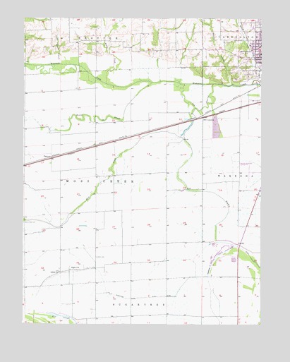
Carrollton West, MO USGS Topographic Map
Click on map above to begin viewing in our Map Viewer.

This topographic map contains these locations and features:
Feature Name Type Latitude Longitude GNIS ID View Map
Austin CemeteryCemeteryN39.2772°W93.5866°713494View Map
Booker SloughStreamN39.3492°W93.5577°714525View Map
Bowdry (historical)Populated PlaceN39.2822°W93.5113°740685View Map
Bowdry LakeLakeN39.2939°W93.5194°714567View Map
Brush CreekStreamN39.3484°W93.5055°714851View Map
Carrollton Memorial AirportAirportN39.3122°W93.5048°758625View Map
Carrollton Recreation LakeReservoirN39.3302°W93.5242°761257View Map
Carrollton Recreation Lake DamDamN39.3350°W93.5252°761256View Map
Costner School (historical)SchoolN39.3367°W93.6244°746977View Map
Dick SchoolSchoolN39.2728°W93.5913°746980View Map
Dirt SloughLakeN39.2532°W93.6053°716912View Map
Fletcher School (historical)SchoolN39.3167°W93.5502°746981View Map
Floyd School (historical)SchoolN39.2759°W93.5608°746983View Map
Gilead CemeteryCemeteryN39.2717°W93.6059°2681405View Map
Gilead ChurchChurchN39.2714°W93.6060°718439View Map
Hilton LakeReservoirN39.3652°W93.5180°763421View Map
Hilton Lake DamDamN39.3650°W93.5169°763420View Map
KAOL-AM (Carrollton)TowerN39.3328°W93.5377°754300View Map
Little Grover BranchStreamN39.3564°W93.6060°721245View Map
McGill CreekStreamN39.3484°W93.5822°722111View Map
Monk LakeReservoirN39.3605°W93.5338°763419View Map
Monk Lake DamDamN39.3600°W93.5335°763418View Map
Moss CreekStreamN39.3267°W93.5425°722675View Map
New School (historical)SchoolN39.3328°W93.5791°746978View Map
Oak Hill CemeteryCemeteryN39.3528°W93.5113°723617View Map
Old Channel Wakenda CreekStreamN39.3484°W93.5255°723741View Map
PalemonPopulated PlaceN39.3181°W93.6105°741135View Map
Sacred Heart CemeteryCemeteryN39.2914°W93.6249°725704View Map
South Baker School (historical)SchoolN39.2970°W93.5124°746982View Map
Stanley BranchStreamN39.3481°W93.5155°727005View Map
SugartreePopulated PlaceN39.2720°W93.5977°727263View Map
Sugartree DitchCanalN39.2606°W93.5672°727264View Map
Township of Moss CreekCivilN39.3100°W93.5882°766416View Map
W B JunctionPopulated PlaceN39.3350°W93.5302°741341View Map
Wilson School (historical)SchoolN39.2714°W93.6235°746979View Map

Note: Coordinates in the location and feature list above are referenced to NAD83 datum.


Copyright (C) 2008-2024 Ryan Niemi / Sunset Dynamics ... All Rights Reserved