TopoQuest Logo
Do you find TopoQuest useful?
Help keep TopoQuest running and adding new maps/features by donating!
Bitcoin:  19c7KJd3qBynnjoSw5npx9KScwjBe4ifkT
Litecoin:  LXs6TkuXGGXo1vDsWCkWVdjQX94eUKd6ui
Home View Maps Find Maps Find Places Resources & Links


Norborne, Missouri Topographic Map

USGS Map Title: Norborne, MO
USGS Map MRC: 39093C6
DRG (GeoTIFF) Download: o39093c6.tif


Neighboring USGS Topographic Map Quads:


  Stet, MO  
39093D7
 

  Roads, MO  
39093D6
 

  Bogard, MO  
39093D5
 

  Hardin, MO  
39093C7
 

  Norborne, MO  
39093C6
 

  Carrollton West, MO  
39093C5
 

  Lexington East, MO  
39093B7
 

  Dover, MO  
39093B6
 

  Waverly, MO  
39093B5


Map MRC Location:

N40°
W94°
N40°
W93°
H8 H7 H6 H5 H4 H3 H2 H1
G8 G7 G6 G5 G4 G3 G2 G1
F8 F7 F6 F5 F4 F3 F2 F1
E8 E7 E6 E5 E4 E3 E2 E1
D8 D7 D6 D5 D4 D3 D2 D1
C8 C7 C6 C5 C4 C3 C2 C1
B8 B7 B6 B5 B4 B3 B2 B1
A8 A7 A6 A5 A4 A3 A2 A1
N39°
W94°
N39°
W93°

Norborne, MO USGS 1:24K Topographic Map Preview:
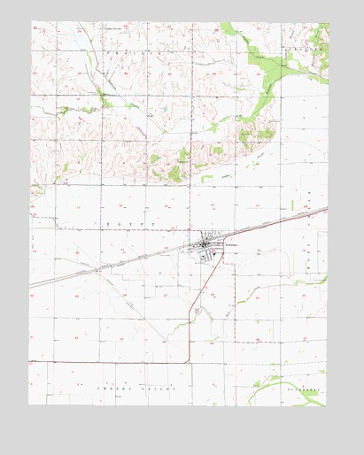
Norborne, MO USGS Topographic Map
Click on map above to begin viewing in our Map Viewer.

This topographic map contains these locations and features:
Feature Name Type Latitude Longitude GNIS ID View Map
Chapel Hill School (historical)SchoolN39.3514°W93.6733°746973View Map
City of NorborneCivilN39.3024°W93.6760°2395245View Map
Cloudis CemeteryCemeteryN39.3386°W93.6583°716011View Map
Double E HeliportAirportN39.2695°W93.6544°758831View Map
Fairhaven CemeteryCemeteryN39.2992°W93.6905°717737View Map
Fairview School (historical)SchoolN39.3222°W93.6730°746974View Map
Fishpond BranchStreamN39.3606°W93.6433°717958View Map
German CemeteryCemeteryN39.3428°W93.6502°718413View Map
Lutheran CemeteryCemeteryN39.3295°W93.6847°721688View Map
Marshall School (historical)SchoolN39.3064°W93.7197°746971View Map
Matthews Lake DamDamN39.3433°W93.7302°762527View Map
McCroskie CreekStreamN39.3575°W93.6288°722068View Map
Nimrod School (historical)SchoolN39.2792°W93.7408°746972View Map
NorbornePopulated PlaceN39.3025°W93.6774°723412View Map
Norborne Drainage DitchCanalN39.2875°W93.7135°723413View Map
Norborne Elementary SchoolSchoolN39.2994°W93.6726°2545469View Map
Norborne High SchoolSchoolN39.2990°W93.6724°2545458View Map
Norborne Police DepartmentBuildingN39.3029°W93.6759°2752286View Map
Norborne Post OfficePost OfficeN39.3027°W93.6753°2782613View Map
Norborne Volunteer Fire DepartmentBuildingN39.3032°W93.6747°2620272View Map
Prairie View SchoolSchoolN39.3728°W93.7205°724898View Map
Providence CemeteryCemeteryN39.3511°W93.7233°724967View Map
Rolling Green School (historical)SchoolN39.3364°W93.7297°746970View Map
Swan Lake School (historical)SchoolN39.3067°W93.6263°746975View Map
Township of EgyptCivilN39.3073°W93.7020°766409View Map
Turkey CreekStreamN39.3586°W93.6338°727859View Map
West Fork Wakenda CreekStreamN39.3472°W93.7074°728581View Map
Wetherholt School (historical)SchoolN39.2714°W93.6688°746976View Map
White LakeReservoirN39.3334°W93.6885°762529View Map
White Lake DamDamN39.3334°W93.6885°762528View Map

Note: Coordinates in the location and feature list above are referenced to NAD83 datum.


Copyright (C) 2008-2024 Ryan Niemi / Sunset Dynamics ... All Rights Reserved