TopoQuest Logo
Do you find TopoQuest useful?
Help keep TopoQuest running and adding new maps/features by donating!
Bitcoin:  19c7KJd3qBynnjoSw5npx9KScwjBe4ifkT
Litecoin:  LXs6TkuXGGXo1vDsWCkWVdjQX94eUKd6ui
Home View Maps Find Maps Find Places Resources & Links


Waverly, Minnesota Topographic Map

USGS Map Title: Waverly, MN
USGS Map MRC: 45093A8
DRG (GeoTIFF) Download: o45093a8.tif


Neighboring USGS Topographic Map Quads:


  Albion Center, MN  
45094B1
 

  Buffalo West, MN  
45093B8
 

  Buffalo East, MN  
45093B7
 

  Howard Lake, MN  
45094A1
 

  Waverly, MN  
45093A8
 

  Delano, MN  
45093A7
 

  Winsted, MN  
44094H1
 

  Mayer, MN  
44093H8
 

  Watertown, MN  
44093H7


Map MRC Location:

N46°
W94°
N46°
W93°
H8 H7 H6 H5 H4 H3 H2 H1
G8 G7 G6 G5 G4 G3 G2 G1
F8 F7 F6 F5 F4 F3 F2 F1
E8 E7 E6 E5 E4 E3 E2 E1
D8 D7 D6 D5 D4 D3 D2 D1
C8 C7 C6 C5 C4 C3 C2 C1
B8 B7 B6 B5 B4 B3 B2 B1
A8 A7 A6 A5 A4 A3 A2 A1
N45°
W94°
N45°
W93°

Waverly, MN USGS 1:24K Topographic Map Preview:
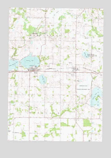
Waverly, MN USGS Topographic Map
Click on map above to begin viewing in our Map Viewer.

This topographic map contains these locations and features:
Feature Name Type Latitude Longitude GNIS ID View Map
Bland School Number 940SchoolN45.0936°W93.8914°640257View Map
Carrigan LakeLakeN45.0575°W93.9548°640934View Map
City of MontroseCivilN45.0665°W93.9202°2395389View Map
City of WaverlyCivilN45.0649°W93.9664°2397226View Map
County Ditch Number ThirtyoneCanalN45.0311°W93.9647°1815365View Map
County Ditch Number TwentytwoCanalN45.0122°W93.9377°1815364View Map
Fall Harvest OrchardLocaleN45.0231°W93.8767°2663756View Map
Fountain LakeLakeN45.0419°W93.8841°643841View Map
Fountain Lake Seaplane BaseAirportN45.0344°W93.8922°660302View Map
Frederick CreekStreamN45.1100°W93.8908°643901View Map
Humphrey Elementary SchoolSchoolN45.0665°W93.9734°2067459View Map
Humphrey-Arends Memorial County ParkParkN45.1027°W93.9641°1815369View Map
Kreidler CemeteryCemeteryN45.0977°W93.8980°646253View Map
Little Waverly DamDamN45.0783°W93.9886°1776552View Map
Little Waverly LakeLakeN45.0710°W93.9966°646964View Map
Little Waverly LakeReservoirN45.0783°W93.9886°1776553View Map
Malardi LakeLakeN45.0815°W93.8978°647400View Map
Malardi Lake State Wildlife Management AreaParkN45.0816°W93.8989°1815368View Map
Mill CreekStreamN45.1147°W93.8980°647848View Map
Mission CemeteryCemeteryN45.0761°W93.9915°647977View Map
MontroseLocaleN45.0694°W93.9125°2067457View Map
MontrosePopulated PlaceN45.0650°W93.9111°648049View Map
Montrose City HallBuildingN45.0661°W93.9114°2067449View Map
Montrose Elementary SchoolSchoolN45.0680°W93.9088°2067450View Map
Montrose Fire DepartmentBuildingN45.0679°W93.9129°2067451View Map
Montrose Manor Mobile Home ParkPopulated PlaceN45.0628°W93.9139°2067456View Map
Montrose Post OfficePost OfficeN45.0654°W93.9135°2067454View Map
Montrose United Methodist ChurchChurchN45.0675°W93.9133°2067452View Map
Mud LakeSwampN45.0526°W93.8989°1777062View Map
North Saint Paul Post Office (historical)Post OfficeN45.0250°W93.9903°2100583View Map
Saint Mary's Catholic ChurchChurchN45.0675°W93.9703°2067458View Map
Saint Marys CemeteryCemeteryN45.0691°W93.9814°650857View Map
Saint Paul's and Trinity Lutheran ChurchChurchN45.0650°W93.9106°2067453View Map
Saint Pauls CemeteryCemeteryN45.0819°W93.9122°1815367View Map
Section Eight SchoolSchoolN45.0430°W93.9875°651829View Map
Swedesburg ChurchChurchN45.1158°W93.9528°652952View Map
Township of MarysvilleCivilN45.1116°W93.9523°664927View Map
Township of WoodlandCivilN45.0187°W93.9522°666043View Map
Twelve Hi Mobile Home EstatesPopulated PlaceN45.0667°W93.9389°2067455View Map
Twelvemile CreekStreamN45.1014°W93.9722°653396View Map
Union Presbyterian ChurchChurchN45.0653°W93.9656°2067460View Map
WaverlyLocaleN45.0661°W93.9683°2067461View Map
WaverlyPopulated PlaceN45.0666°W93.9664°653859View Map
Waverly Fire and RescueBuildingN45.0666°W93.9693°2666551View Map
Waverly Group HomeHospitalN45.0667°W93.9661°2067462View Map
Waverly LakeLakeN45.0742°W93.9714°653861View Map
Waverly Post OfficePost OfficeN45.0674°W93.9682°2067528View Map
Waverly Village HallBuildingN45.0667°W93.9661°2067463View Map
Woodland CemeteryCemeteryN45.0076°W93.9916°654357View Map
Woodland SchoolSchoolN45.0222°W93.9308°654363View Map
Woodland State Wildlife Management AreaDamN45.0533°W93.8919°1777061View Map
Wright CemeteryCemeteryN45.0636°W93.9211°1815366View Map

Note: Coordinates in the location and feature list above are referenced to NAD83 datum.


Copyright (C) 2008-2024 Ryan Niemi / Sunset Dynamics ... All Rights Reserved